
File:Levant (orthographic projection).png
Size o this luikower: 600 × 600 pixels. Ither resolutions: 240 × 240 pixels | 480 × 480 pixels | 768 × 768 pixels | 1,024 × 1,024 pixels | 2,000 × 2,000 pixels.
Oreeginal file (2,000 × 2,000 pixels, file size: 632 KB, MIME type: image/png)
Ootline
| Descreeption |
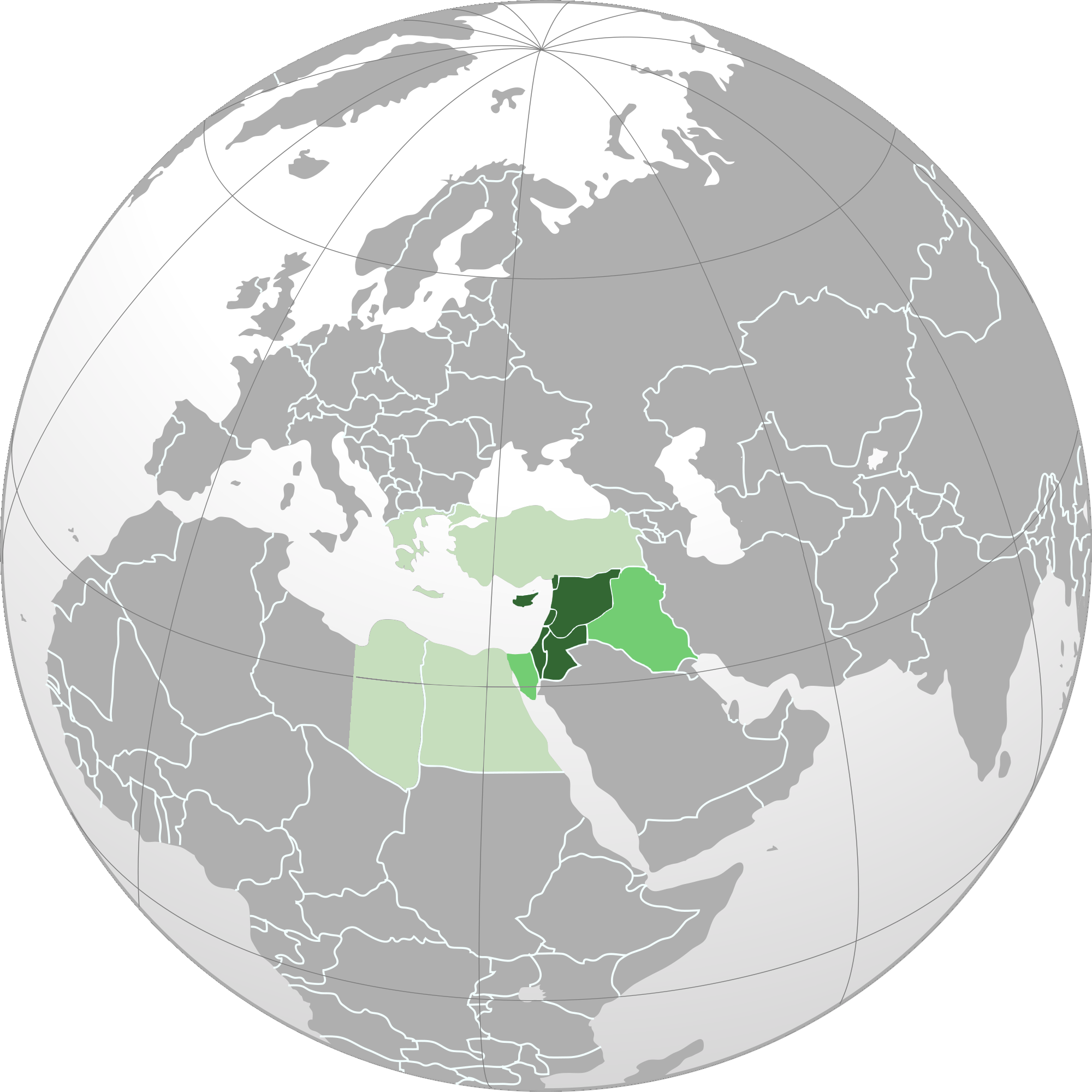
English: Orthographic map of Levant.
العربية: الخريطة الإرشادية لبلاد الشام.
اللون الأخضر الداكن: البلدان والمناطق الواقعة في منطقة المشرق العربي. (سوريا ولبنان وفلسطين والأردن وقبرص وهاتاي) اللون الأخضر المتوسط (بين الداكن والباهت): أراضي كاملة من البلدان التي يتم تضمين مناطقها في منطقة المشرق العربي. (العراق وسيناء) اللون الأخضر الباهت: البلدان والمناطق المدرجة أحيانًا في منطقة بلاد الشام. (اليونان وتركيا ومصر) |
| Date | |
| Soorce |
Ain wirk Based on File:Norhern_Cyprus_(orthographic_projection).png by user:Seksen iki yüz kırk beş |
| Author | Winkpolve |
.svg)
.svg)
.svg)
.svg)
.svg)
.svg)
.svg)
.svg)
.svg)
.svg)
.svg)
.svg)
.svg)
.svg)
.svg)
.svg)
.svg)
.svg)
.svg)
.svg)
.svg)
.svg)
.svg)
.svg)
.svg)
.svg)
.svg)
.svg)
.svg)
.svg)
.svg)
.svg)
.svg)
.svg)
.svg)
.svg)
.svg)
.svg)
.svg)
.svg)
.svg)
.svg)
.svg)
.svg)
.svg)
.svg)
.svg)
.svg)
.svg)
.svg)
.svg)
.svg)
.svg)
.svg)
.svg)
.svg)
.svg)
.svg)
.svg)
.svg)
.svg)
.svg)
.svg)
.svg)
.svg)
.svg)
.svg)
.svg)
.svg)
.svg)
.svg)
.svg)
.svg)
.svg)

.svg)

.svg)

.svg)
.svg)
.svg)
.svg)
.svg)
.svg)
.svg)


.svg)
.svg)
.svg)
.svg)
.svg)
.svg)
.svg)

.svg)
.svg)
.svg)
.svg)
.svg)
.svg)
.svg)
.svg)
.svg)

.svg)
.svg)
.svg)
.svg)
.svg)
.svg)
.svg)
_without_national_boundaries.svg)
.svg)
.svg)
.svg)
.svg)
.svg)
.svg)

.svg)
.svg)
.png)
.svg)
.svg)
.svg)
.svg)

.svg)
.svg)
.svg)
.svg)
.svg)
.svg)
.svg)
.svg)
.svg)
.svg)
.svg)

.svg)
.svg)
.svg)
.svg)
.svg)
.svg)
.svg)
.svg)
.svg)

.svg)
.svg)

.svg)
.svg)
.svg)
.svg)
.svg)
.svg)
.svg)
.svg)
.svg)
.svg)
.svg)
.svg)
.svg)
.svg)
.svg)
.svg)
.svg)
.svg)
.svg)
.svg)
.svg)
.svg)
.svg)
.svg)
.svg)
.svg)
.svg)
_-_Crimea_disputed.svg)
.svg)
.svg)
.svg)
.svg)
.svg)
.svg)
.svg)
.svg)
.svg)
.svg)
.svg)
_political.svg)
.svg)
.svg)
.svg)
.svg)
_-_Crimea_disputed_-_no_borders.svg)
.svg)
.svg)
.svg)
.svg)
.svg)
.svg)
.svg)
.svg)
.svg)
.svg)
.svg)

.svg)
.svg)
.svg)

.png)
.svg)
.svg)
.svg)
.svg)
.svg)
.svg)
.svg)
.svg)
.svg)
.svg)
.svg)
.svg)
.svg)
.svg)
.svg)
.svg)
.svg)
.svg)
.svg)
.svg)
.svg)
.svg)
.svg)
.svg)
.svg)
.svg)
.svg)
.svg)
.svg)
.svg)
.svg)
.svg)
.svg)
.svg)
.png)
.svg)
.svg)
.svg)
_(orthographic_projection).png)
.png)
.png)
| Orthographic projections maps created by Ssolbergj |
|---|
| Orthographic projections maps created by Ssolbergj: |
.svg)
.svg)
Licensin
I, the copyright holder of this work, hereby publish it under the following license:
This file is licensed unner the Creative Commons Attribution-Share Alike 3.0 Unported license.
- Ye are free:
- tae share – tae copy, distribute an transmit the wirk
- tae remix – tae adapt the wirk
- Unner the follaein condeetions:
- attribution – Ye must attribute the wirk in the manner specified bi the author or licensor (but nae in ony way that suggests that thay endorse ye or yer uise o the wirk).
- share alik – If ye alter, transform, or big upon this wirk, ye mey distribute the resultin wirk anly unner the same or seemilar license tae this ane.
File history
Clap oan ae date/time fer tae see the file aes it kithed at that time.
| Date/Time | Thummnail | Dimensions | Uiser | Comment | |
|---|---|---|---|---|---|
| current | 00:18, 18 Mey 2015 | | 2,000 × 2,000 (632 KB) | HD86 | changed boundaries of the Levant based on the sources cited in the article. |
| 18:33, 28 October 2013 |  | 2,000 × 2,000 (679 KB) | Hohum | Remove confusing Cyprus insert | |
| 05:40, 26 September 2012 |  | 2,000 × 2,000 (587 KB) | Mttll | Colored East Thrace of Turkey as national territory. | |
| 02:20, 28 August 2012 |  | 2,000 × 2,000 (447 KB) | Winkpolve | User created page with UploadWizard |
Eimage airtins
The follaein pages airts tae this image:
Global file uisage
The follaein ither wikis uise this file:
- Uisage on af.wikipedia.org
- Uisage on ar.wikipedia.org
- Uisage on ar.wiktionary.org
- Uisage on azb.wikipedia.org
- Uisage on bn.wikipedia.org
- Uisage on ca.wikipedia.org
- Uisage on de.wikipedia.org
- Uisage on en.wikipedia.org
- Uisage on en.wikibooks.org
- Uisage on en.wikivoyage.org
- Uisage on es.wikipedia.org
- Uisage on et.wikipedia.org
- Uisage on fa.wikipedia.org
- Uisage on ga.wikipedia.org
- Uisage on gl.wikipedia.org
- Uisage on he.wikipedia.org
- Uisage on he.wikivoyage.org
- Uisage on hi.wikipedia.org
- Uisage on id.wikipedia.org
- Uisage on incubator.wikimedia.org
- Uisage on ja.wikipedia.org
- Uisage on kk.wikipedia.org
- Uisage on ko.wikipedia.org
- Uisage on ku.wikipedia.org
- Uisage on lfn.wikipedia.org
- Uisage on ml.wikipedia.org
- Uisage on ms.wikipedia.org
- Uisage on pa.wikipedia.org
- Uisage on pl.wikipedia.org
- Dyskusja:Operacja Entebbe
- Dyskusja:Limor Liwnat
- Dyskusja:Pokój z Aleppo
- Dyskusja:Amir Perec
- Dyskusja:Awigdor Lieberman
- Dyskusja:Mordechaj Nurok
- Dyskusja:Me’ir Porusz
- Dyskusja:Ze’ew Elkin
- Dyskusja:Icchak Szamir
- Dyskusja:Binjamin Netanjahu
- Wikiprojekt:Tygodnie tematyczne/Tydzień Artykułu Lewantyńskiego
- Dyskusja:Ranunculus chius
- Dyskusja:Ranunculus constantinopolitanus
- Dyskusja:Ranunculus cornutus
- Dyskusja:Uri Orbach
View mair global usage o this file.
.png)
.png)