
File:Kassite Babylonia EN.svg

Size of this PNG preview of this SVG file: 661 × 580 pixels. Ither resolutions: 274 × 240 pixels | 547 × 480 pixels | 875 × 768 pixels | 1,167 × 1,024 pixels | 2,334 × 2,048 pixels.
Oreeginal file (SVG file, nominallie 661 × 580 pixels, file size: 183 KB)
Ootline
| Descreeption |
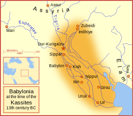
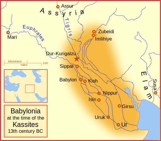
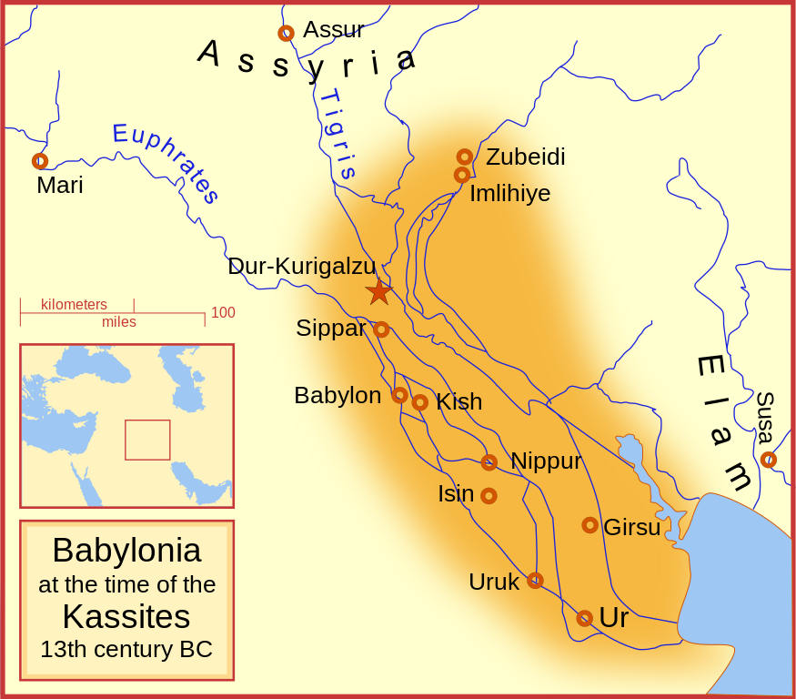
English: A map of the Babylonian Empire during the time of the Kassites, roughly the 13th century BC. This map shows the probable river courses and coastline at that time. Català: Babilònia durant la dinastia cassita (s. XIII aC) |
|||||
| Date | ||||||
| Soorce | Ain wirk | |||||
| Author | MapMaster | |||||
| Other versions |
File:Kassite Babylonia EN.svg has 5 translations.
|


Other versions
Similar maps
References
- Roaf, M. (1990) Cultural Atlas of Mesopotamia and the ancient Near East, Oxford: Facts on File. (In general, the basis for the ancient river courses and ancient coastline).
Licensin
I, the copyright holder of this work, hereby publish it under the following licenses:

|
Permission is grantit tae copy, distribute an/or modify this document unner the terms o the GNU Free Documentation License, Version 1.2 or ony later version published bi the Free Software Foundation; wi no Invariant Sections, no Front-Cover Texts, an no Back-Cover Texts. A copy o the license is includit in the section enteetled GNU Free Documentation License. |
This file is licensed under the Creative Commons Attribution-Share Alike 4.0 International, 3.0 Unported, 2.5 Generic, 2.0 Generic and 1.0 Generic license.
- Ye are free:
- tae share – tae copy, distribute an transmit the wirk
- tae remix – tae adapt the wirk
- Unner the follaein condeetions:
- attribution – Ye must attribute the wirk in the manner specified bi the author or licensor (but nae in ony way that suggests that thay endorse ye or yer uise o the wirk).
- share alik – If ye alter, transform, or big upon this wirk, ye mey distribute the resultin wirk anly unner the same or seemilar license tae this ane.
Ye mey select the license o yer choice.
File history
Clap oan ae date/time fer tae see the file aes it kithed at that time.
| Date/Time | Thummnail | Dimensions | Uiser | Comment | |
|---|---|---|---|---|---|
| current | 06:54, 20 September 2023 | | 661 × 580 (183 KB) | Jaumellecha | File uploaded using svgtranslate tool (https://svgtranslate.toolforge.org/). Added translation for ca. |
| 17:39, 3 Mairch 2008 |  | 661 × 580 (177 KB) | MapMaster | {{Information |Description=A map of the Babylonian Empire during the time of the Kassites, roughly the 13th century BC |Source=self-made |Date=3 March 2008 |Author= MapMaster |Permission= |other_versions= }} |
Eimage airtins
The'r nae pages airts tae this eimage.
Global file uisage
The follaein ither wikis uise this file:
- Uisage on ar.wikipedia.org
- Uisage on azb.wikipedia.org
- Uisage on az.wikipedia.org
- Uisage on be.wikipedia.org
- Uisage on bg.wikipedia.org
- Uisage on br.wikipedia.org
- Uisage on ca.wikipedia.org
- Uisage on ceb.wikipedia.org
- Uisage on ckb.wikipedia.org
- Uisage on cs.wikipedia.org
- Uisage on cv.wikipedia.org
- Uisage on de.wikipedia.org
- Uisage on en.wikipedia.org
- Babylonia
- Kassites
- Amarna Period
- List of conflicts in Asia
- Kassite dynasty
- Middle Babylonian period
- User:SomeGuyWhoRandomlyEdits/List of conflicts in the Near East
- Renaissance of Sumer
- User:A.X.Wiki.Editor/Middle Babylonian period
- User:A.X.Wiki.Editor/List of conflicts in Iraq
- User:SomeGuyWhoRandomlyEdits/Kassite dynasty
- Uisage on en.wikibooks.org
- Uisage on fa.wikipedia.org
- Uisage on fa.wikibooks.org
- Uisage on fi.wikipedia.org
- Uisage on fr.wiktionary.org
- Uisage on he.wikipedia.org
- Uisage on hr.wikipedia.org
View mair global usage o this file.