
File:Irrawaddyrivermap.jpg
Size o this luikower: 421 × 599 pixels. Ither resolutions: 168 × 240 pixels | 337 × 480 pixels | 862 × 1,227 pixels.
Oreeginal file (862 × 1,227 pixels, file size: 208 KB, MIME type: image/jpeg)
Ootline
| Descreeption |
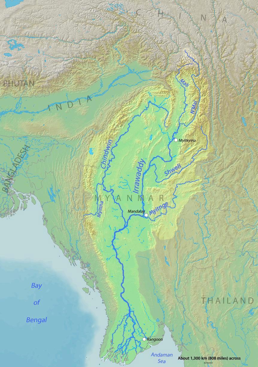
English: Map of the Irrawaddy River, which drains parts of Myanmar (Burma), Thailand and India into the Andaman Sea Français : Carte de l'Irrawaddy. Myitnge |
| Date | |
| Soorce | Background and river course data from http://www2.demis.nl/mapserver/mapper.asp |
| Author | Shannon |
Licensin
I, the copyright holder of this work, hereby publish it under the following licenses:

|
Permission is grantit tae copy, distribute an/or modify this document unner the terms o the GNU Free Documentation License, Version 1.2 or ony later version published bi the Free Software Foundation; wi no Invariant Sections, no Front-Cover Texts, an no Back-Cover Texts. A copy o the license is includit in the section enteetled GNU Free Documentation License. |
This file is licensed under the Creative Commons Attribution-Share Alike 4.0 International, 3.0 Unported, 2.5 Generic, 2.0 Generic and 1.0 Generic license.
- Ye are free:
- tae share – tae copy, distribute an transmit the wirk
- tae remix – tae adapt the wirk
- Unner the follaein condeetions:
- attribution – Ye must attribute the wirk in the manner specified bi the author or licensor (but nae in ony way that suggests that thay endorse ye or yer uise o the wirk).
- share alik – If ye alter, transform, or big upon this wirk, ye mey distribute the resultin wirk anly unner the same or seemilar license tae this ane.
Ye mey select the license o yer choice.
File history
Clap oan ae date/time fer tae see the file aes it kithed at that time.
| Date/Time | Thummnail | Dimensions | Uiser | Comment | |
|---|---|---|---|---|---|
| current | 00:32, 1 December 2015 | | 862 × 1,227 (208 KB) | Xufanc | Myittha River |
| 08:30, 30 November 2015 |  | 862 × 1,227 (208 KB) | Xufanc | Reverted to version as of 08:22, 30 November 2015 (UTC) | |
| 08:28, 30 November 2015 |  | 862 × 1,227 (208 KB) | Xufanc | Reverted to version as of 08:18, 30 November 2015 (UTC) | |
| 08:25, 30 November 2015 |  | 862 × 1,227 (208 KB) | Xufanc | Reverted to version as of 08:18, 30 November 2015 (UTC) | |
| 08:22, 30 November 2015 |  | 862 × 1,227 (208 KB) | Xufanc | added name of tributary | |
| 08:18, 30 November 2015 |  | 862 × 1,227 (208 KB) | Xufanc | added name of tributary | |
| 06:38, 24 September 2014 |  | 862 × 1,227 (219 KB) | Xufanc | Corrected wrong label | |
| 04:06, 3 Mairch 2010 |  | 862 × 1,227 (653 KB) | Shannon1 | {{Information |Description={{en|1=Map of the Irrawaddy River, which drains parts of Myanmar (Burma), Thailand and India into the Andaman Sea}} |Source=Background and river course data from http://www2.demis.nl/mapserver/mapper.asp |Author=[[User:Shannonc |
Eimage airtins
The'r nae pages airts tae this eimage.
Global file uisage
The follaein ither wikis uise this file:
- Uisage on af.wikipedia.org
- Uisage on ar.wikipedia.org
- Uisage on ast.wikipedia.org
- Uisage on azb.wikipedia.org
- Uisage on be-tarask.wikipedia.org
- Uisage on bg.wikipedia.org
- Uisage on bh.wikipedia.org
- Uisage on blk.wikipedia.org
- Uisage on bn.wikipedia.org
- Uisage on br.wikipedia.org
- Uisage on ca.wikipedia.org
- Uisage on cs.wikipedia.org
- Uisage on cy.wikipedia.org
- Uisage on de.wikipedia.org
- Uisage on en.wikipedia.org
- Uisage on en.wikinews.org
- Uisage on es.wikipedia.org
- Uisage on eu.wikipedia.org
- Uisage on fa.wikipedia.org
- Uisage on fr.wikipedia.org
- Uisage on gl.wikipedia.org
- Uisage on hi.wikipedia.org
- Uisage on hr.wikipedia.org
- Uisage on hu.wikipedia.org
- Uisage on hy.wikipedia.org
- Uisage on id.wikipedia.org
- Uisage on ja.wikipedia.org
- Uisage on ka.wikipedia.org
- Uisage on ko.wikipedia.org
- Uisage on mk.wikipedia.org
- Uisage on ml.wikipedia.org
- Uisage on my.wikipedia.org
View mair global usage o this file.