
File:Iran topo-fr.jpg

Size o this luikower: 650 × 599 pixels. Ither resolutions: 260 × 240 pixels | 521 × 480 pixels | 833 × 768 pixels | 1,110 × 1,024 pixels | 1,400 × 1,291 pixels.
Oreeginal file (1,400 × 1,291 pixels, file size: 722 KB, MIME type: image/jpeg)
Ootline
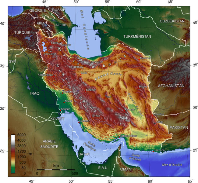
| Descreeption | Topographic map in French of Iran |
| Date | |
| Soorce | en:Image:Iran_topo_en.jpg created by de:Captain Blood |
| Author | Translation : Eric Gaba (Sting) |
| Permission (Reuisin this file) |
GFDL |
| Other versions | Original version in English : en:Image:Iran_topo_en.jpg |
Français : * Sujet : Carte topographique en français de l'Iran ;
- Source : en:Image:Iran_topo_en.jpg créée par de:Captain Blood ;
- Auteur de la traduction : Eric Gaba (fr:Sting) ;
- Date : Septembre 2006.
Licensin
The map has been created with the Generic Mapping Tools: https://www.generic-mapping-tools.org/ using one or more of these public-domain datasets for the relief:
|

|
Permission is grantit tae copy, distribute an/or modify this document unner the terms o the GNU Free Documentation License, Version 1.2 or ony later version published bi the Free Software Foundation; wi no Invariant Sections, no Front-Cover Texts, an no Back-Cover Texts. A copy o the license is includit in the section enteetled GNU Free Documentation License. |
| This file is licensed unner the Creative Commons Attribution-Share Alike 3.0 Unported license. | ||
| ||
| This licensing tag was added to this file as part of the GFDL licensing update. |
File history
Clap oan ae date/time fer tae see the file aes it kithed at that time.
| Date/Time | Thummnail | Dimensions | Uiser | Comment | |
|---|---|---|---|---|---|
| current | 21:59, 14 September 2006 | | 1,400 × 1,291 (722 KB) | Sting | "Turkménistan" correction |
| 21:52, 14 September 2006 |  | 1,400 × 1,291 (722 KB) | Sting | {{Information |Description=Topographic map in French of Iran |Source=en:Image:Iran_topo_en.jpg created by de:Captain Blood |Date=September 2006 |Author=Translation : Eric Gaba (Sting) |Permission=GFDL |other |
Eimage airtins
The'r nae pages airts tae this eimage.
Global file uisage
The follaein ither wikis uise this file:
- Uisage on ba.wikipedia.org
- Uisage on be.wikipedia.org
- Uisage on bg.wikipedia.org
- Uisage on de.wikipedia.org
- Uisage on el.wikipedia.org
- Uisage on eu.wikipedia.org
- Uisage on fr.wikipedia.org
- Uisage on hi.wikipedia.org
- Uisage on hy.wikipedia.org
- Uisage on ja.wikipedia.org
- Uisage on ko.wikipedia.org
- Uisage on ku.wikipedia.org
- Uisage on ky.wikipedia.org
- Uisage on mg.wikipedia.org
- Uisage on mk.wikipedia.org
- Uisage on ms.wikipedia.org
- Uisage on nl.wikipedia.org
- Uisage on os.wikipedia.org
- Uisage on pa.wikipedia.org
- Uisage on pcd.wikipedia.org
- Uisage on ru.wikipedia.org
- Uisage on sl.wikipedia.org
- Uisage on sq.wikipedia.org
- Uisage on ur.wikipedia.org
- Uisage on uz.wikipedia.org