
File:Ile-de-France region relief location map.jpg

Size o this luikower: 742 × 600 pixels. Ither resolutions: 297 × 240 pixels | 594 × 480 pixels | 951 × 768 pixels | 1,267 × 1,024 pixels | 1,651 × 1,334 pixels.
Oreeginal file (1,651 × 1,334 pixels, file size: 552 KB, MIME type: image/jpeg)
Ootline
| Camera location | | View this and other nearby images on: OpenStreetMap |
|---|
| Descreeption |
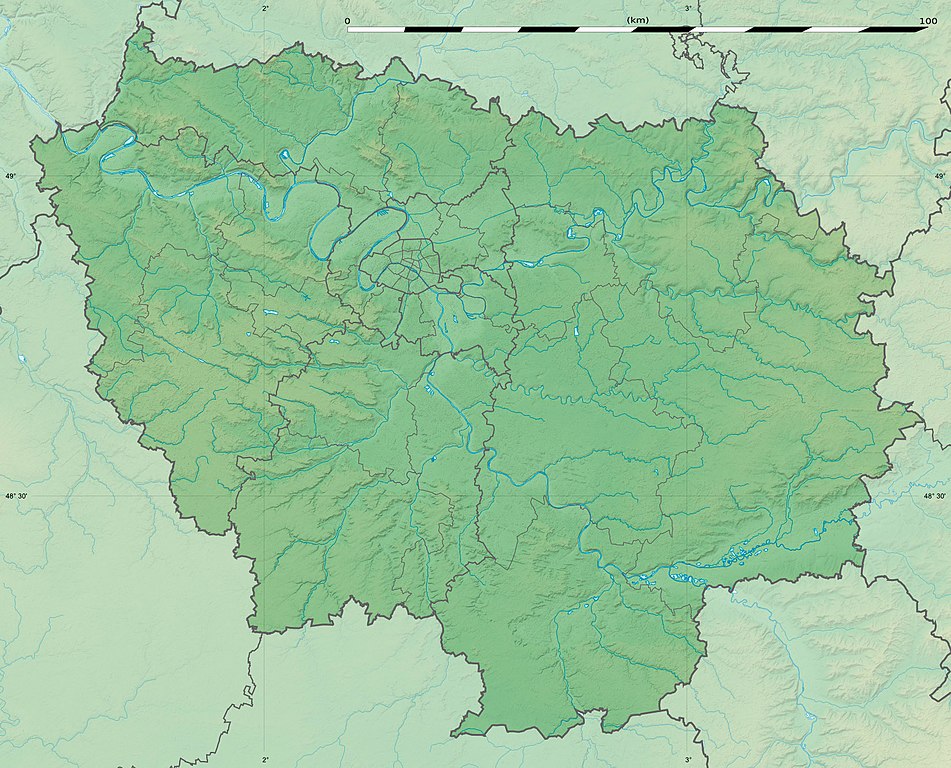
English: Blank physical map of the region of Île-de-France, France, as in January 2015, for geo-location purpose, with distinct boundaries for regions, departments and arrondissements.
Français : Carte physique vierge de la région Île-de-France, France, telle qu'en janvier 2015, destinée à la géolocalisation, avec limite distincte des régions, départements et arrondissements. Scale:
Equirectangular projection, WGS84 datum
Geographic limits of the map:
|
||
| Date | |||
| Soorce |
Ain wirk
|
||
| Author | Eric Gaba (Sting - fr:Sting) | ||
| Permission (Reuisin this file) |
|
||
| Other versions |
|

Licensin
Eric Gaba, Wikimedia Commons user Sting, the copyright holder of this work, hereby publishes it under the following license:
This file is licensed unner the Creative Commons Attribution-Share Alike 3.0 Unported license.
Attribution: Eric Gaba, Wikimedia Commons user Sting
- Ye are free:
- tae share – tae copy, distribute an transmit the wirk
- tae remix – tae adapt the wirk
- Unner the follaein condeetions:
- attribution – Ye must attribute the wirk in the manner specified bi the author or licensor (but nae in ony way that suggests that thay endorse ye or yer uise o the wirk).
- share alik – If ye alter, transform, or big upon this wirk, ye mey distribute the resultin wirk anly unner the same or seemilar license tae this ane.
File history
Clap oan ae date/time fer tae see the file aes it kithed at that time.
| Date/Time | Thummnail | Dimensions | Uiser | Comment | |
|---|---|---|---|---|---|
| current | 15:32, 12 Februar 2015 | | 1,651 × 1,334 (552 KB) | Sting | Color profile |
| 15:21, 12 Februar 2015 |  | 1,651 × 1,334 (537 KB) | Sting | Boundaries correction | |
| 16:26, 22 Januar 2015 |  | 1,651 × 1,334 (605 KB) | Sting | Boundaries correction | |
| 13:57, 21 Januar 2015 |  | 1,651 × 1,334 (598 KB) | Sting | == {{int:filedesc}} == {{Location|48|40|30|N|02|30|00|E|scale:1000000}} {{Information |Description={{en|Blank physical map of the region of Île-de-France, France, as in January 2015, for geo-location purpose, with distinct bound... |
Eimage airtins
The follaein pages airts tae this image:
Global file uisage
The follaein ither wikis uise this file:
- Uisage on als.wikipedia.org
- Uisage on ast.wikipedia.org
- Uisage on ban.wikipedia.org
- Uisage on bg.wikipedia.org
- Париж
- Версай
- Курбьовоа
- Ньой сюр Сен
- Сюрен
- Булон Биянкур
- Со
- Аниер сюр Сен
- Бобини
- Мол (Франция)
- Самоа сюр Сен
- Аржантьой
- Фонтенбло
- Епине сюр Сен
- Вил д'Авре
- Сен Жермен ан Ле
- Сен Дени
- Иври сюр Сен
- Екол политекник
- Вилжуиф
- Монтрьой
- Нантер
- Кретей
- Олне су Боа
- Витри сюр Сен
- Коломб
- Шампини сюр Марн
- Рюей Малмезон
- Сен Мор де Фосе
- Шаблон:ПК Франция Ил дьо Франс
- Жоанвил льо Пон
- Монфермей
- Есман
- Етамп
- Удан
- Мелюн
- Аверн
- Барбизон
- Обержанвил
- Епон
- Монтро Фот Йон
- Маси
- Монжерон
- Сен Морис (Ил дьо Франс)
- Армантиер ан Бри
- Мо
View mair global usage o this file.