
File:Haute-Normandie region relief location map.jpg

Size o this luikower: 465 × 600 pixels. Ither resolutions: 186 × 240 pixels | 372 × 480 pixels | 969 × 1,250 pixels.
Oreeginal file (969 × 1,250 pixels, file size: 294 KB, MIME type: image/jpeg)
Ootline
| Camera location | | View this and other nearby images on: OpenStreetMap |
|---|
| Descreeption |
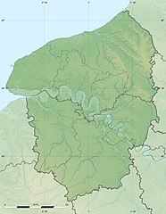
English: Blank physical map of the region of Upper Normandy, France, for geo-location purpose, with distinct boundaries for regions, departments and arrondissements.
Français : Carte physique vierge de la région de Haute-Normandie, France, destinée à la géolocalisation, avec limite distincte des régions, départements et arrondissements. Scales:
Equirectangular projection, WGS84 datum
Geographic limits of the map:
|
||
| Date | |||
| Soorce |
Ain wirk
|
||
| Author | Eric Gaba (Sting - fr:Sting) | ||
| Permission (Reuisin this file) |
|
||
| Other versions |
|

Licensin
Eric Gaba, Wikimedia Commons user Sting, the copyright holder of this work, hereby publishes it under the following license:
This file is licensed unner the Creative Commons Attribution-Share Alike 3.0 Unported license.
Attribution: Eric Gaba, Wikimedia Commons user Sting
- Ye are free:
- tae share – tae copy, distribute an transmit the wirk
- tae remix – tae adapt the wirk
- Unner the follaein condeetions:
- attribution – Ye must attribute the wirk in the manner specified bi the author or licensor (but nae in ony way that suggests that thay endorse ye or yer uise o the wirk).
- share alik – If ye alter, transform, or big upon this wirk, ye mey distribute the resultin wirk anly unner the same or seemilar license tae this ane.
File history
Clap oan ae date/time fer tae see the file aes it kithed at that time.
| Date/Time | Thummnail | Dimensions | Uiser | Comment | |
|---|---|---|---|---|---|
| current | 21:15, 18 Julie 2010 | | 969 × 1,250 (294 KB) | Sting | Color profile |
| 17:03, 10 Mairch 2010 |  | 969 × 1,250 (302 KB) | Sting | == {{int:filedesc}} == {{Location|49|21|45|N|00|56|15|E|scale:500000}} <br/> {{Information |Description={{en|Blank physical map of the region of Upper Normandy, France, for geo-location purpose, with distinct boundaries for regions, |
Eimage airtins
The follaein pages airts tae this image:
Global file uisage
The follaein ither wikis uise this file:
- Uisage on ar.wikipedia.org
- Uisage on bg.wikipedia.org
- Uisage on ca.wikipedia.org
- Uisage on ceb.wikipedia.org
- Uisage on ce.wikipedia.org
- Uisage on cs.wikipedia.org
- Uisage on de.wikipedia.org
- Uisage on el.wikipedia.org
- Uisage on en.wikipedia.org
- Uisage on eo.wikipedia.org
- Uisage on es.wikipedia.org
- Uisage on fa.wikipedia.org
- Uisage on fr.wikipedia.org
- Bataille de Mortemer
- Circuit de Rouen-les-Essarts
- Parc éolien en mer de Fécamp
- Projet:Cartographie/Cartes standards/France
- Parc éolien en mer des Deux-Côtes
- Modèle:Géolocalisation/Haute-Normandie
- Modèle:Géolocdual/Haute-Normandie
- Modèle:Géolocalisation/Haute-Normandie/Documentation
- Wikipédia:Atelier graphique/Cartes/Archives/juin 2010
- Circuit de Dieppe
- Lac de Caniel
- Utilisateur:Wikisoft*/Projet:Cartographie/Géolocalisation/Maintenance/Images des régions françaises
- Projet:Cartographie/Géolocalisation/Maintenance/Images des régions françaises
- Abbaye Saint-Laurent de Beaubec
- Combat de la Rougemare et des Flamants
- Module:Carte/données/haute-normandie
- Uisage on gl.wikipedia.org
- Uisage on gv.wikipedia.org
- Uisage on he.wikipedia.org
- Uisage on ja.wikipedia.org
- Uisage on kk.wikipedia.org
- Uisage on kn.wikipedia.org
- Uisage on ko.wikipedia.org
- Uisage on la.wikipedia.org
- Uisage on lrc.wikipedia.org
- Uisage on ms.wikipedia.org
- Uisage on pcd.wikipedia.org
- Uisage on pl.wikipedia.org
View mair global usage o this file.