
File:Former Broxburn Shale Oil Works - geograph.org.uk - 1018508.jpg
Nae heier resolution available.
Former_Broxburn_Shale_Oil_Works_-_geograph.org.uk_-_1018508.jpg (640 × 480 pixels, file size: 86 KB, MIME type: image/jpeg)
Ootline
| Descreeption |
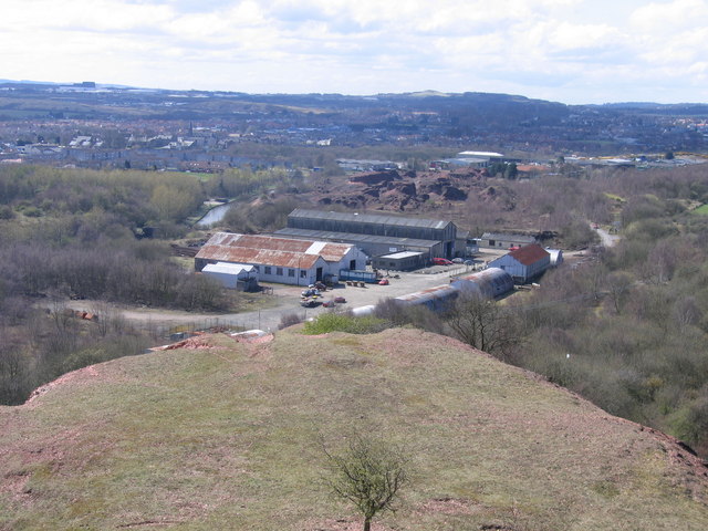
English: Former Broxburn Shale Oil Works Taken from the top of the tip comprising the waste rock from which the oil has been extracted, the surviving buildings of the former shale oil works, now known as Albyn Industrial Estate, are in the middle of the picture, with the villages of Broxburn and, to the right, Uphall beyond and some of the buildings of Livingston New Town visible on the far skyline. |
| Date | |
| Soorce | From geograph.org.uk |
| Author | A-M-Jervis |
| Attribution (required by the license) | A-M-Jervis / Former Broxburn Shale Oil Works / |
| Camera location | | View this and other nearby images on: OpenStreetMap |
|---|
_heading:225.00&language=sco)
| Object location | | View this and other nearby images on: OpenStreetMap |
|---|
_heading:225.00&language=sco)
Licensin

|
This image was taken from the Geograph project collection. See this photograph's page on the Geograph website for the photographer's contact details. The copyright on this image is owned by A-M-Jervis and is licensed for reuse under the Creative Commons Attribution-ShareAlike 2.0 license.
|
This file is licensed under the Creative Commons Attribution-Share Alike 2.0 Generic license.
Attribution: A-M-Jervis
- Ye are free:
- tae share – tae copy, distribute an transmit the wirk
- tae remix – tae adapt the wirk
- Unner the follaein condeetions:
- attribution – Ye must attribute the wirk in the manner specified bi the author or licensor (but nae in ony way that suggests that thay endorse ye or yer uise o the wirk).
- share alik – If ye alter, transform, or big upon this wirk, ye mey distribute the resultin wirk anly unner the same or seemilar license tae this ane.
File history
Clap oan ae date/time fer tae see the file aes it kithed at that time.
| Date/Time | Thummnail | Dimensions | Uiser | Comment | |
|---|---|---|---|---|---|
| current | 10:48, 23 Februar 2011 | | 640 × 480 (86 KB) | GeographBot | == {{int:filedesc}} == {{Information |description={{en|1=Former Broxburn Shale Oil Works Taken from the top of the tip comprising the waste rock from which the oil has been extracted, the surviving buildings of the former shale oil works, now known as Alb |
Eimage airtins
The follaein pages airts tae this image:
Global file uisage
The follaein ither wikis uise this file:
- Uisage on azb.wikipedia.org
- Uisage on en.wikipedia.org
- Uisage on fr.wikipedia.org
- Uisage on nl.wikipedia.org