
File:Crete topographic map-fr.svg

Size of this PNG preview of this SVG file: 800 × 380 pixels. Ither resolutions: 320 × 152 pixels | 640 × 304 pixels | 1,024 × 486 pixels | 1,280 × 608 pixels | 2,560 × 1,215 pixels | 3,370 × 1,600 pixels.
Oreeginal file (SVG file, nominallie 3,370 × 1,600 pixels, file size: 2.6 MB)
Ootline
| Camera location | | View this and other nearby images on: OpenStreetMap |
|---|
| Descreeption |
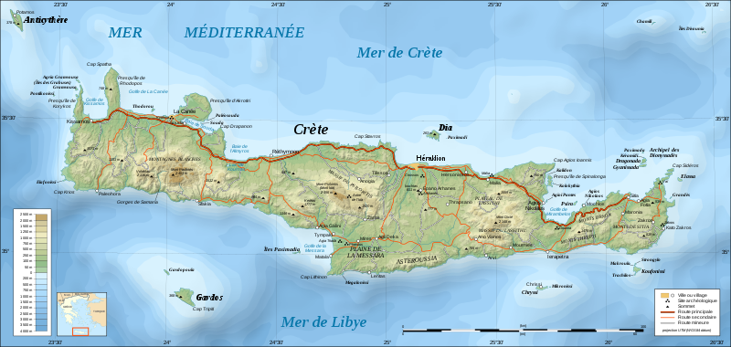
UTM projection; WGS84 datum; shaded relief (composite image of N-W, W and N lightning positions)
|
||
| Date | |||
| Soorce |
Own work;
|
||
| Author | Eric Gaba (Sting - fr:Sting) | ||
| Permission (Reuisin this file) |
|
||
| Other versions |
Derivative works of this file: Crete location map.svg
[]
|


|
This SVG file contains embedded text that can be translated into your language, using any capable SVG editor, text editor or the SVG Translate tool. For more information see: About translating SVG files. |
Licensin
I, the copyright holder of this work, hereby publish it under the following licenses:

|
Permission is grantit tae copy, distribute an/or modify this document unner the terms o the GNU Free Documentation License, Version 1.2 or ony later version published bi the Free Software Foundation; wi no Invariant Sections, no Front-Cover Texts, an no Back-Cover Texts. A copy o the license is includit in the section enteetled GNU Free Documentation License. |
This file is licensed under the Creative Commons Attribution-Share Alike Attribution-Share Alike 4.0 International, 3.0 Unported, 2.5 Generic, 2.0 Generic and 1.0 Generic license.
- Ye are free:
- tae share – tae copy, distribute an transmit the wirk
- tae remix – tae adapt the wirk
- Unner the follaein condeetions:
- attribution – Ye must attribute the wirk in the manner specified bi the author or licensor (but nae in ony way that suggests that thay endorse ye or yer uise o the wirk).
- share alik – If ye alter, transform, or big upon this wirk, ye mey distribute the resultin wirk anly unner the same or seemilar license tae this ane.
Ye mey select the license o yer choice.
File history
Clap oan ae date/time fer tae see the file aes it kithed at that time.
| Date/Time | Thummnail | Dimensions | Uiser | Comment | |
|---|---|---|---|---|---|
| current | 19:30, 17 Juin 2008 | | 3,370 × 1,600 (2.6 MB) | Sting | Colors of bathymetry changed ; other modifications |
| 22:38, 3 December 2007 |  | 3,370 × 1,600 (2.11 MB) | Sting | 2 archaeological sites added | |
| 14:08, 2 December 2007 |  | 3,370 × 1,600 (2.11 MB) | Sting | Slight text rendering improvements | |
| 21:09, 1 December 2007 |  | 3,370 × 1,600 (2.11 MB) | Sting | {{Information |Description=Topographic map in French of Crete island, Greece |Source=Own work ;<br/>Topography : [http://www2.jpl.nasa.gov/srtm NASA Shuttle Radar Topography Mission] (SRTM3 v.2) data (public domain) edited wit |
Eimage airtins
The'r nae pages airts tae this eimage.
Global file uisage
The follaein ither wikis uise this file:
- Uisage on hu.wikipedia.org
- Uisage on pl.wiktionary.org