
File:Coconino County incorporated areas Flagstaff highlighted.svg

Size of this PNG preview of this SVG file: 500 × 600 pixels. Ither resolutions: 200 × 240 pixels | 400 × 480 pixels | 640 × 768 pixels | 853 × 1,024 pixels | 1,707 × 2,048 pixels | 700 × 840 pixels.
Oreeginal file (SVG file, nominallie 700 × 840 pixels, file size: 59 KB)
Ootline
| Descreeption |
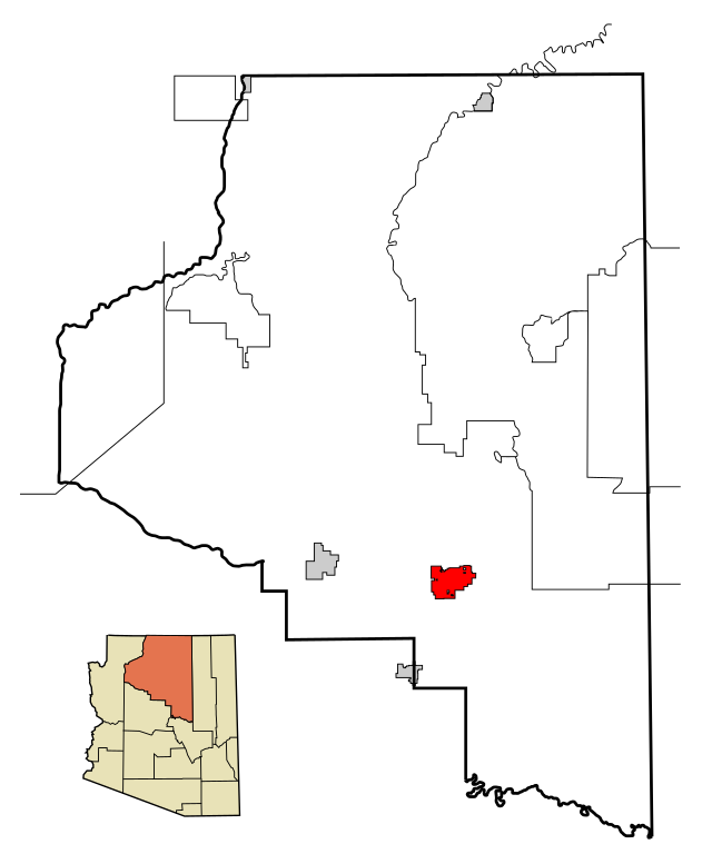
This map shows the incorporated areas and Indian reservations in Coconino County, Arizona.
|
| Date | |
| Soorce | My own work, based on public domain information. Based on similar map concepts by Ixnayonthetimmay |
| Author | Arkyan |
| Permission (Reuisin this file) |
Copyleft-type licensing. See below. |
| Other versions | See Category:Maps of Coconino County for other versions of this image. |
Licensin
I, the copyright holder of this work, hereby publish it under the following licenses:

|
Permission is grantit tae copy, distribute an/or modify this document unner the terms o the GNU Free Documentation License, Version 1.2 or ony later version published bi the Free Software Foundation; wi no Invariant Sections, no Front-Cover Texts, an no Back-Cover Texts. A copy o the license is includit in the section enteetled GNU Free Documentation License. |
| This file is licensed unner the Creative Commons Attribution-Share Alike 3.0 Unported license. | ||
| ||
| This licensing tag was added to this file as part of the GFDL licensing update. |
This file is licensed under the Creative Commons Attribution-Share Alike 2.5 Generic, 2.0 Generic and 1.0 Generic license.
- Ye are free:
- tae share – tae copy, distribute an transmit the wirk
- tae remix – tae adapt the wirk
- Unner the follaein condeetions:
- attribution – Ye must attribute the wirk in the manner specified bi the author or licensor (but nae in ony way that suggests that thay endorse ye or yer uise o the wirk).
- share alik – If ye alter, transform, or big upon this wirk, ye mey distribute the resultin wirk anly unner the same or seemilar license tae this ane.
Ye mey select the license o yer choice.
File history
Clap oan ae date/time fer tae see the file aes it kithed at that time.
| Date/Time | Thummnail | Dimensions | Uiser | Comment | |
|---|---|---|---|---|---|
| current | 22:56, 21 Mairch 2007 | | 700 × 840 (59 KB) | Shereth | {{Information |Description=This map shows the incorporated areas and Indian reservations in Coconino County, Arizona, highlighting Flagstaff in red. I created |
Eimage airtins
The'r nae pages airts tae this eimage.
Global file uisage
The follaein ither wikis uise this file:
- Uisage on af.wikipedia.org
- Uisage on ar.wikipedia.org
- Uisage on arz.wikipedia.org
- Uisage on ba.wikipedia.org
- Uisage on ca.wikipedia.org
- Uisage on ceb.wikipedia.org
- Uisage on cy.wikipedia.org
- Uisage on de.wikipedia.org
- Uisage on el.wikipedia.org
- Uisage on eo.wikipedia.org
- Uisage on et.wikipedia.org
- Uisage on eu.wikipedia.org
- Uisage on fr.wikipedia.org
- Uisage on fy.wikipedia.org
- Uisage on ga.wikipedia.org
- Uisage on gl.wikipedia.org
- Uisage on ht.wikipedia.org
- Uisage on hu.wikipedia.org
- Uisage on ia.wikipedia.org
- Uisage on id.wikipedia.org
- Uisage on lad.wikipedia.org
- Uisage on la.wikipedia.org
- Uisage on lb.wikipedia.org
- Uisage on pt.wikipedia.org
- Uisage on ro.wikipedia.org
- Uisage on sk.wikipedia.org
- Uisage on sr.wikipedia.org
- Uisage on th.wikipedia.org
- Uisage on tr.wikipedia.org
- Uisage on tt.wikipedia.org
- Uisage on ur.wikipedia.org
- Uisage on vi.wikipedia.org
- Uisage on vo.wikipedia.org
- Uisage on www.wikidata.org
- Uisage on zh-min-nan.wikipedia.org
- Uisage on zh.wikipedia.org