
File:CapeHornDetailMap.png
Size o this luikower: 800 × 482 pixels. Ither resolutions: 320 × 193 pixels | 640 × 386 pixels | 906 × 546 pixels.
Oreeginal file (906 × 546 pixels, file size: 91 KB, MIME type: image/png)
Ootline
| Descreeption |
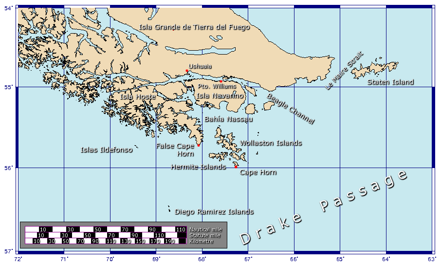
Español: Detalle de las islas cerca del Cabo de Hornos
Generated using GMT. |
| Date | 27 Januar 2006 (original upload date) |
| Soorce | Ain wirk |
| Author | Johantheghost |
Licensin
I, the copyright holder of this work, hereby publish it under the following licenses:

|
Permission is grantit tae copy, distribute an/or modify this document unner the terms o the GNU Free Documentation License, Version 1.2 or ony later version published bi the Free Software Foundation; wi no Invariant Sections, no Front-Cover Texts, an no Back-Cover Texts. A copy o the license is includit in the section enteetled GNU Free Documentation License. |
| This file is licensed unner the Creative Commons Attribution-Share Alike 3.0 Unported license. | ||
| ||
| This licensing tag was added to this file as part of the GFDL licensing update. |
This file is licensed under the Creative Commons Attribution-Share Alike 2.5 Generic, 2.0 Generic and 1.0 Generic license.
- Ye are free:
- tae share – tae copy, distribute an transmit the wirk
- tae remix – tae adapt the wirk
- Unner the follaein condeetions:
- attribution – Ye must attribute the wirk in the manner specified bi the author or licensor (but nae in ony way that suggests that thay endorse ye or yer uise o the wirk).
- share alik – If ye alter, transform, or big upon this wirk, ye mey distribute the resultin wirk anly unner the same or seemilar license tae this ane.
Ye mey select the license o yer choice.
File history
Clap oan ae date/time fer tae see the file aes it kithed at that time.
| Date/Time | Thummnail | Dimensions | Uiser | Comment | |
|---|---|---|---|---|---|
| current | 16:17, 21 November 2009 | | 906 × 546 (91 KB) | Botaurus | functionless line (borderline) removed |
| 12:22, 9 Februar 2006 |  | 906 × 546 (91 KB) | Johantheghost | Less violent colours. | |
| 00:25, 28 Januar 2006 |  | 906 × 546 (90 KB) | Johantheghost | Fix scale! | |
| 20:20, 27 Januar 2006 |  | 906 × 546 (87 KB) | Johantheghost | Scale and false cape | |
| 16:34, 27 Januar 2006 |  | 906 × 546 (81 KB) | Johantheghost | A map showing the location of Cape Horn, including part of the Drake Passage. Generated using [http://gmt.soest.hawaii.edu/ GMT]. |
Eimage airtins
The follaein pages airts tae this image:
Global file uisage
The follaein ither wikis uise this file:
- Uisage on af.wikipedia.org
- Uisage on als.wikipedia.org
- Uisage on ar.wikipedia.org
- Uisage on ast.wikipedia.org
- Uisage on az.wikipedia.org
- Uisage on be-tarask.wikipedia.org
- Uisage on be.wikipedia.org
- Uisage on bg.wikipedia.org
- Uisage on br.wikipedia.org
- Uisage on bs.wikipedia.org
- Uisage on ca.wikipedia.org
- Uisage on ceb.wikipedia.org
- Uisage on ckb.wikipedia.org
- Uisage on cy.wikipedia.org
- Uisage on da.wikipedia.org
- Uisage on de.wikipedia.org
- Uisage on el.wikipedia.org
- Uisage on en.wikipedia.org
- Uisage on eo.wikipedia.org
- Uisage on es.wikipedia.org
- Uisage on et.wikipedia.org
- Uisage on eu.wikipedia.org
- Uisage on fa.wikipedia.org
- Uisage on fi.wikipedia.org
- Uisage on frr.wikipedia.org
- Uisage on fr.wikipedia.org
View mair global usage o this file.