
File:Bobcat Lynx rufus distribution map.png

Oreeginal file (704 × 800 pixels, file size: 124 KB, MIME type: image/png)
Ootline
| Descreeption |
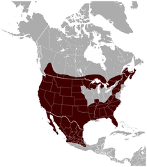
English: Geographical distribution of the Bobcat Lynx rufus, with national borders added. The map was created using the Generic Mapping Tools, GMT, version 5.1.1. |
| Date | |
| Soorce |
Own work using: the IUCN Red List spatial data to draw the borders of the Lynx rufus range: |
| Author | Darekk2 using the IUCN Red List spatial data |
| Other versions |
|

Licensin
Attribution: The author of the work and the IUCN Red List spatial data.
You must provide the appropriate credit for the IUCN Red List spatial data:
IUCN (International Union for Conservation of Nature) 2008. Lynx rufus. In: IUCN 2014. The IUCN Red List of Threatened Species. Version 2014.3. http://www.iucnredlist.org. Downloaded on 25 February 2015.
and the IUCN Red List spatial data
- Ye are free:
- tae share – tae copy, distribute an transmit the wirk
- tae remix – tae adapt the wirk
- Unner the follaein condeetions:
- attribution – Ye must attribute the wirk in the manner specified bi the author or licensor (but nae in ony way that suggests that thay endorse ye or yer uise o the wirk).
- share alik – If ye alter, transform, or big upon this wirk, ye mey distribute the resultin wirk anly unner the same or seemilar license tae this ane.
File history
Clap oan ae date/time fer tae see the file aes it kithed at that time.
| Date/Time | Thummnail | Dimensions | Uiser | Comment | |
|---|---|---|---|---|---|
| current | 23:53, 26 Mey 2015 | | 704 × 800 (124 KB) | Darekk2 | thicker borders of states |
| 17:30, 20 Mairch 2015 |  | 703 × 800 (117 KB) | Darekk2 | removed transparency of the background | |
| 16:19, 15 Mairch 2015 |  | 703 × 800 (129 KB) | Darekk2 | previously an incorrect map was used as the background, the range in Mexico was incomplete | |
| 16:10, 15 Mairch 2015 |  | 800 × 771 (139 KB) | Darekk2 | uncovered Lake Superior ... | |
| 16:09, 25 Februar 2015 |  | 705 × 800 (128 KB) | Darekk2 | User created page with UploadWizard |
Eimage airtins
The'r nae pages airts tae this eimage.
Global file uisage
The follaein ither wikis uise this file:
- Uisage on en.wikipedia.org
- Uisage on fy.wikipedia.org
- Uisage on tr.wikipedia.org
- Uisage on vi.wikipedia.org