
File:AxelHeibergIslandCloseupMap.png
Nae heier resolution available.
AxelHeibergIslandCloseupMap.png (499 × 449 pixels, file size: 13 KB, MIME type: image/png)
Ootline
| Descreeption |
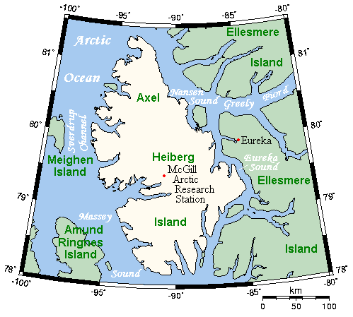
English: A map of Axel Heiberg Island, Nunavut, Canada, and surrounding islands and waterways. |
| Date | |
| Soorce | This map's source is here, with the uploader's modifications, and the GMT homepage says that the tools are released under the GNU General Public License. |
| Author | Kelisi at en.wikipedia |
Licensin
Kelisi from en.wikipedia.org, the copyright holder of this work, hereby publishes it under the following license:
| This file is licensed unner the Creative Commons Attribution-Share Alike 3.0 Unported license. Subject to disclaimers. | ||
| Attribution: Kelisi from en.wikipedia.org | ||
| ||
| This licensing tag was added to this file as part of the GFDL licensing update. |

|
Permission is grantit tae copy, distribute an/or modify this document unner the terms o the GNU Free Documentation License, Version 1.2 or ony later version published bi the Free Software Foundation; wi no Invariant Sections, no Front-Cover Texts, an no Back-Cover Texts. A copy o the license is includit in the section enteetled GNU Free Documentation License. Subject to disclaimers. |
Original upload log
(del) (cur) 19:38, 26 March 2006 . . Kelisi (Talk) . . 499x449 (17403 bytes) (A map of Axel Heiberg Island, Nunavut, and surrounding islands and waterways. This map's source is [http://www.aquarius.ifm-geomar.de/ here], with the uploader's modifications, and the [http://gmt.soest.hawaii.edu/ GMT homepage] says that the tools are released under the GNU General Public License).
File history
Clap oan ae date/time fer tae see the file aes it kithed at that time.
| Date/Time | Thummnail | Dimensions | Uiser | Comment | |
|---|---|---|---|---|---|
| current | 13:37, 9 November 2007 | | 499 × 449 (13 KB) | MaxSem | pngcrush'ed |
| 15:19, 23 Apryle 2006 |  | 499 × 449 (17 KB) | MaxSem | Original description: <tt> A map of Axel Heiberg Island, Nunavut, and surrounding islands and waterways. This map's source is here, with the uploader's modifications, and the GMT homepage says that the tools are released under the GNU General Public Licen |
Eimage airtins
The'r nae pages airts tae this eimage.
Global file uisage
The follaein ither wikis uise this file:
- Uisage on af.wikipedia.org
- Uisage on ast.wikipedia.org
- Uisage on az.wikipedia.org
- Uisage on ba.wikipedia.org
- Uisage on bg.wikipedia.org
- Uisage on ca.wikipedia.org
- Uisage on ceb.wikipedia.org
- Uisage on cs.wikipedia.org
- Uisage on da.wikipedia.org
- Uisage on de.wikipedia.org
- Uisage on en.wikipedia.org
- Uisage on es.wikipedia.org
- Uisage on fa.wikipedia.org
- Uisage on gl.wikipedia.org
- Uisage on hu.wikipedia.org
- Uisage on it.wikipedia.org
- Uisage on ka.wikipedia.org
- Uisage on nl.wikipedia.org
- Uisage on nn.wikipedia.org
- Uisage on no.wikipedia.org
- Uisage on pl.wikipedia.org
- Uisage on pt.wikipedia.org
- Uisage on ro.wikipedia.org
- Uisage on ru.wikipedia.org
- Uisage on simple.wikipedia.org
- Uisage on sr.wikipedia.org
- Uisage on uk.wikipedia.org
- Uisage on vi.wikipedia.org
- Uisage on war.wikipedia.org
- Uisage on www.wikidata.org
- Uisage on zh.wikipedia.org