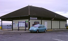
Montrose railwey station
| Montrose | |
|---|---|
| Scots Gaelic: Mon Rois | |
 Montrose railway station | |
| Location | |
| Place | Montrose |
| Local authority | Angus |
| Coordinates | 56°42′46″N 2°28′20″W / 56.7129°N 2.4722°WCoordinates: 56°42′46″N 2°28′20″W / 56.7129°N 2.4722°W |
| Grid reference | NO711579 |
| Operations | |
| Station code | MTS |
| Managed bi | First ScotRail |
| Nummer o platforms | 2 |
| Live arrivals/departurs, station information an onwart connections frae National Rail Enquiries | |
| Annual rail passenger uissage* | |
| 2011/12 | |
| 2012/13 | |
| 2013/14 | |
| 2014/15 | |
| 2015/16 | |
| History | |
| 1883 | Appent |
| National Rail – UK railwey stations | |
| * Annual estimatit passenger uissage based on sales o tickets in statit financial year(s) that end or oreeginate at Montrose frae Office of Rail and Road statistics. Methodology mey vary year on year. | |
| UK Railweys portal | |
Montrose railway station serves the toun o Montrose in Angus, Scotland. The station owerleuks the Montrose Basin an is situatit on the Edinburgh to Aberdeen Line, 90 mile (144 km) north o Edinburgh Waverley railwey station.
| Precedin station | Follaein station | |||
|---|---|---|---|---|
| Arbroath | CrossCountry Cross Country Network |
Stanehyve | ||
| Arbroath | Abellio ScotRail Glasgow to Aberdeen Line Edinburgh to Aberdeen Line |
Lowrenkirk | ||
| Arbroath | Caledonian Sleeper Highland Caledonian Sleeper |
Stanehyve | ||
| Arbroath | Virgin Trains East Coast East Coast Main Line |
Stanehyve | ||
| Historical railweys | ||||
| Lunan Bay Line appen; Station closed |
North British, Arbroath and Montrose Railway | Hillside Line appen; Station closed | ||
| Terminus | Montrose and Bervie Railway | Broomfield Line closed; Station closed | ||
