
Auld Luice

Auld Luice (English: Old Luce) is a ceevil pairish in the historical coonty o Wigtounshire in Dumfries an Gallowa, Scotland. The pairish is aboot 10 mile lang and 8 mile wide, an conteens 40,350 acre.[1]
It wis in auncient times named Glenluice that wis dividen intae twa pairshes, the northren ane name't New Luice, an the soothren ane name't Auld Luice.[2] [3] In 1661 the twa pairishes o Auld an New Luice wis reunitit for a time, an whan the 1684 Wigtounshire Pairish Leet wis recordit, it leetit baith Auld Luice an New Luice unner "Glenluice Pairish".[4] In 1688, efter the Glorious Revolution, the separation o Auld Luice an New Luice becam permanent. Auld Luice haes a community cooncil.[5]
Veelages an places in Auld Luice[eedit | eedit soorce]
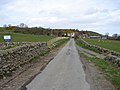
The toun o Glenluice an Glenluice Kirk is in Auld Luice Pairish, as is Glenluice Aibey. In 1846 the Topographical Dictionary o Scotland, Samuel Lewis wrate that the veelage o Glenluice wis situatit on the road leadin fae Newtoun Stewart tae Stranrawer. "The church, erected in 1814, is a commodious edifice, and situated close to the village. The members of the United Secession Church have a place of worship. There are several other schools, and one is supported by the Hay family."[6]
Dunragit (Scots Gaelic: Dùn Reicheit) is a veelage on the A75 road atween Stranrawer an Glenluice in Auld Luice. The place name haes been said tae derive fae Din Rheged meanin "Fort o Rheged". This wad refer til the Brythonic Daurk Ages Kinrick o Rheged that seems tae hae existit somewhaur in this aurie o the Mairch atween England an Scotland atween the 5t an 8t centurys. It is possible that this wis ane o the ryal sites uised bi the kings o Rheged an it his been suggestit as the site o the unidentified Northren Ryal Coort Penrhyn Rhionedd, recordit in the Welsh Triads. Thare is a possible Roman cremation seemetry an twa castle mottes in the veelage. The ex-King o Dublin an Man, Echmarcach mac Ragnaill, haed the title Rex Innarenn ("Keeng o the Rhins") attributit tae him on his deith in 1065. The wastren airts o Gallowa haed been firm in line wi the Isle o Man, an Norse an Gaelic-Norse dounset names fae the 10t an 11t centurys is spreid aw alang the coastal launds o soothwast Scotland. Glenwhan Gairden haed been creatit in Dunragit syne 1979, and is nouadays appen til the public.
Carscreugh Castle (o the Yerl o Stair in 1782) wis the hame o Janet Dalrymple, that Sir Walter Scott steidit his heroine Lucy, the Bride of Lammermoor (that becam Lucia di Lammermoor in Gaetano Donizetti's opera o the same name) on. Janet fell in luve wi an in saicret haund-festit til a sillerless local man, Archibald Rutherford. Her paurents bitter cried again this romance an gart her tae renunce her vou an gart her tae mairy anither man fae a walthie local faimily, Sir David Dunbar o Baldoon Castle near Wigtoun. Houiver something dreidfu happent on her waddin nicht that endit in her deith an the woundin o her guidman, that ever efterwart refuised tae lat ken tae onybody whait hid occurt that nicht.
Archaeology[eedit | eedit soorce]
Fae Glenluice Saunds there hae been rekivert "mair objects o antiquity nor fae ony aurie o similar extent in Scotland". The relicts range fae neolithic tae medieval times.[7][8]
St John's Chaipel at The Knock o Luice wis at ae time a chaipel o St John. The tenant, Mr Wilson, telt Rev. George Wilson o Glenluice that he remuived three perqueer streetit fluirs, the tane abuin the tither. This shawed a lang occupation.[9]
Forts an brochs[eedit | eedit soorce]
Rev. George Wilson o Glenluice, in his Archaeological and Historical Collections relating to Ayrshire and Galloway, tells that Wigtounshire conteens aboot saxty forts; 15 in Mochrum, 4 in Glasserton, 10 in Whithorn, an several mair in the ither pairishes not name't in his leet. He leets the follaein forts in Auld Luice:[10][11]
- Three at Glenhinnie or Glenhinney bothy circles, Dunragit Muir[12]
- Twa at Glenwhan, Dunragit
- Twa in a wuid cried Baraigle near Dunragit
- Round Dounan, Dunragit Hoose, north Dunragit veelage[13] A stane built 5t-6t century fort o Rheged on a naitural hillock o ootcroppin rock, 12-14 fit heich wi an 18 fit terrace on the wast side
- Twa on Craig, ilk wi a bothy circle (Mebbe Auld Haw o Craig at Airyhemming)
- Three forts at Airyhemming, ane wi a cup-shape't fluir at ae end[14]
- Stairhaven broch[15]
- A fort a quarter-mile sooth o the pier shawn on the OS map as a cairn[16]
- Near Law Sunnonness fort cried Garliachen[17]
- Ring on Mull o Sunonness (mebbe Garliachen)
- On Barhaskine at the Carlinwark[18]
- Fortified toun on Knock Hill. The Knock, Auld Luice, or Knock o Luice or Knock Fell fort.[19] This auncient fortified veelage staunds on the heichest hill in Auld Luice an micht hae been built bi the makkers o the vast loch dwallins in Machermore Loch aboot twa mile til the wast. Thare wis hints o 6 or 7 bothy circles alang the line o fortification an ootby on a smaw flet space on the brent northren side thare wis a hauf-circle o aboot 20 fit across. Doun the wastren slope thare wis a boorach o smaw cairns, an a boorach o green bothy circles.[20]
- Ring on Barnsallzie Muir, Barnsallie Bothy Circle[21]
- Circular fort at Drumearnachan (at Barlea or Barfad, Kirkcowan), not on OS map, bit detailt on p. 56 vol.III[22]
- Mooth o the River Piltanton Corrylinn or Corachlinn
- Heich torrs cried Knockdoon
Droughdool Mote or Mund, sooth Dunragit veelage, has a steid 156 fit wide, is 30 fit heich, wi a level tap 40 fit wide.[23]
Dunragit henge atween the Mund an Dunragit veelage is ane o the maist important Stane Age sites in Scotland. It is a pit define't cursus moniment, datin fae Neolithic an Bronze age times. It wis first diskivert bi aerial photography in 1992. The Dunragit Excavations Project archaeological howkin haes appluised the remeens o three gey muckle concentric timmer circles; the ooter circle wis 984 fit wide, amwast sax times the size o Stonehenge. Built aroond 2500 BC(E), this gey muckle moniment wis a ceremonial centre an a meetin place for soothwast Scotlands early fermin communitys.[24][25]
Crannogs[eedit | eedit soorce]
Whitefield Loch his twa crannogs: Dormans Island crannog o 250 BC(E); an Tree Island crannog. The latter is noo on dry laund acause o the fawen watter level in the loch.[26] Whitefield is near Machermore, the auncient castle o the MacDowall Clan.
Gailerie[eedit | eedit soorce]
-
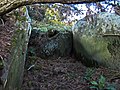
 Carscreugh Castle
 -
 Milton Brig near site o Kirkchrist chaipel an well
 -
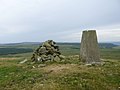 Knock Fell trig (Knock Hill Fort)
 -
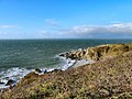
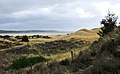
 Knock o Luice (Knock Fell), view f Fort location fae Mull o Sinniness
 -
 Knock o Luice auncient veelage fort. Rock face on brent northren sclent
 -
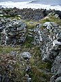 Stairhaven Airn-age broch - intramural stairs
 -
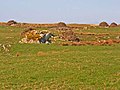
 Black Cairn
 -
 Heigh Gillespie chaumbert cairn
 -
 Garliachen Fort, Laigh Sinniness, Auld Luice
 -
 near 3 forts at Airyhemming (Arehemen)
 -
 possibly Tree Island Crannog, Whitefield Loch - Machermore Loch
 -
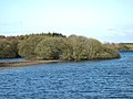 Dorman's Island Crannog, Whitefield Loch - Machermore Loch
 -
 Machermore, Barony Glenluice, o Clan Macdowall
 -
 Glenwhan Gairden in Dunragit
 -
 Ringadoo Pynt near Dunragit


Leetit biggins in Auld Luice[eedit | eedit soorce]
- Glenluce, Ladyburn Masonic Temple, (Former Ladyburn Church), With Railings And Gates
- Glenluce, 17 Main Street
- Glenluce, 141 And 143 Main Street,Minn Cree And Woodbank, With Garden Walls
- Glenluce, 62 And 64 Main Street, Fernlea And Roseneath
- Glenluce, 72 Main Street
- Grennan, Farmhouse, Steading, Sundial And Boundary Walls
- North Milton, Farmhouse And Steading
- Drochduil School And Schoolhouse
- Dunragit, The Kennels
- Glenluce, 7 Church Street, Kirkton
- Glenluce, 35-39 (Odd Nos) Main Street
- Glenluce, 53 Main Street, Kelvin House Hotel
- Glenluce, 16 And 18 Main Street
- Glenluce, 76 Main Street
- Laigh Sinniness, Former Farmhouse And Steading
- Glenluce, Ladyburn Manse
- Glenluce, 61 Main Street
- Glenluce, 161 And 163 Main Street, Beechgrove And Ravenswood, With Railings
- Glenluce, 34 Main Street
- Glenluce, 36 Main Street, Crown Hotel
- Glenluce, 38 Main Street, Rowantree
- Glenluce, Millbank And Cottage
- Castle Of Park
- Craigenveoch
- Auchenmalg, Auchenbrae, With Boundary Walls
- Bridge Of Park
- Dunragit Home Farm, Sundial
- Glenluce, 28A Main Street
- Glenluce, War Memorial
- Carscreugh Castle
- Carscreugh Castle, Cottages
- Culroy, Farm Building
- Dunragit, East Lodge
- Bridge, Lady Burn
- Genoch Doocot
- Glenluce, 31 Main Street, King's Arms Hotel
- Glenluce, 47 Main Street, Ardville
- Glenluce, 57 And 59 Main Street
- Glenluce, 2 Main Street, With Railings
- Glenluce, 20 Main Street
- Glenluce, 30 Main Street, With Railings
- Glenluce, 32 Main Street
- Glenluce, 52 And 54 Main Street
- Glenluce, 1A Sun Street
- Abbey House With Boundary Walls
- Gillespie, Farmhouse And Steading
- Glenluce, 19 Main Street, Royal Bank Of Scotland
- Glenluce, 22 Main Street, Public Hall
- Glenluce, North Street, Bridge
- Old Luce Church, Graveyard, Graveyard Walls, Gatepiers And Gates
- Glenluce, Ladyburn Bridge
- Glenluce, 43 And 45 Main Street
- Glenluce, 12 Main Street
- Stair Haven, Store
- Dunragit, Signal Box
- Auchenmalg, Castle Daly Hotel, (Former School And Schoolhouse), With Boundary Walls
- Dunragit House
- Glenluce, Church Street, Bridge
- Glenluce, 55 Main Street
- Glenluce, 165 Main Street, Navarre, With Railings
- Glenluce, 24 Main Street, Otterburn
- Piltanton Bridge
References[eedit | eedit soorce]
- ↑ http://www.scottish-places.info/parishes/parmap1063.html
- ↑ Caledonia Vol. III by George Chalmers, London, printed 1824., pp.441-442 https://archive.org/stream/caledoniaoraccou03chal#page/441/mode/1up
- ↑ Robert Chambers, William Chambers, The gazetteer of Scotland, Vol. II, Edinburgh, 1844, p. 500 & p.749, https://archive.org/stream/gazetteerofscov21838cham#page/n7/mode/2up
- ↑ https://archive.org/stream/parishlistsofwig72scot#page/10/mode/2up
- ↑ http://www.glenluce-online.org.uk/old_luce_community_council.html Archived 2013-07-26 at the Wayback Machine
- ↑ A Topographical Dictionary of Scotland, by Samuel Lewis. 1846
- ↑ "Kirkcudbrightshire and Wigtownshire"
- ↑ http://www.megalithic.co.uk/article.php?sid=25441 Archived 2016-03-04 at the Wayback Machine
- ↑ https://archive.org/stream/churchdedicatio01mackuoft#page/280/mode/2up
- ↑ Archaeological and Historical Collections relating to Ayrshire and Galloway. vol. V, pp.62-73 https://archive.org/stream/cu31924092901606#page/n115/mode/2up
- ↑ Archaeological and Historical Collections relating to Ayrshire and Galloway. vol. III, p.56 http://www26.us.archive.org/stream/cu31924092901580#page/n93/mode/2up
- ↑ http://canmore.rcahms.gov.uk/en/site/61289/details/dunragit+moor/[deid airtin]
- ↑ "Archived copy". Archived frae the original on 2 Apryle 2015. Retrieved 5 Apryle 2020.CS1 maint: archived copy as title (link)
- ↑ http://canmore.rcahms.gov.uk/en/site/61173/details/old+hall+of+craig+airyhemming/[deid airtin]
- ↑ http://www.megalithic.co.uk/article.php?sid=26005
- ↑ http://maps.nls.uk/os/6inch/view/?sid=74431142#sid=74431142&zoom=6&lat=7746&lon=14340&layers=BT
- ↑ http://canmore.rcahms.gov.uk/en/site/62239/details/garliachen+laigh+sinniness/[deid airtin]
- ↑ The Carlinwark on Craignaget Fell http://canmore.rcahms.gov.uk/en/site/62224/details/craignarget+hill+the+carlinwark/[deid airtin]
- ↑ http://www.megalithic.co.uk/article.php?sid=10331
- ↑ Antiquities of Glenluce. Rev. George Wilson. 1899
- ↑ http://canmore.rcahms.gov.uk/en/site/62171/details/barnsallie+fell/[deid airtin]
- ↑ Archaeological and Historical Collections relating to Ayrshire and Galloway. vol.III, p.56 http://www26.us.archive.org/stream/cu31924092901580#page/n93/mode/2up
- ↑ http://canmore.rcahms.gov.uk/en/site/61278/details/droughdool+mote/
- ↑ Dunragit Cursus Excavations "Archived copy". Archived frae the original on 19 Mey 2014. Retrieved 3 September 2013.CS1 maint: archived copy as title (link) "Archived copy". Archived frae the original on 19 Mey 2014. Retrieved 5 Apryle 2020.CS1 maint: archived copy as title (link) CS1 maint: BOT: original-url status unknown (link) Dunragit Cursus Excavations
- ↑ "Archived copy". Archived frae the original on 19 Mey 2014. Retrieved 3 September 2013.CS1 maint: archived copy as title (link) "Archived copy". Archived frae the original on 19 Mey 2014. Retrieved 5 Apryle 2020.CS1 maint: archived copy as title (link) CS1 maint: BOT: original-url status unknown (link)
- ↑ http://canmore.rcahms.gov.uk/en/site/62160/details/dorman+s+island+whitefield+loch/
| Wikimedia Commons haes media relatit tae Old Luce. |