
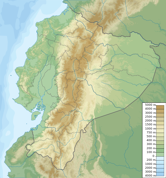
File:Ecuador relief location map.svg

Size of this PNG preview of this SVG file: 556 × 599 pixels. Ither resolutions: 223 × 240 pixels | 445 × 480 pixels | 713 × 768 pixels | 950 × 1,024 pixels | 1,901 × 2,048 pixels | 851 × 917 pixels.
Oreeginal file (SVG file, nominallie 851 × 917 pixels, file size: 3.76 MB)
Ootline
| Descreeption | Ecuador physical map, parameters equal to File:Ecuador location map.svg |
| Date | |
| Soorce | Ain wirk |
| Author | Urutseg |
Licensin
I, the copyright holder of this work, hereby publish it under the following license:
| This file is made available under the Creative Commons CC0 1.0 Universal Public Domain Dedication. | |
| The person who associated a work with this deed has dedicated the work to the public domain by waiving all of their rights to the work worldwide under copyright law, including all related and neighboring rights, to the extent allowed by law. You can copy, modify, distribute and perform the work, even for commercial purposes, all without asking permission.
|
File history
Clap oan ae date/time fer tae see the file aes it kithed at that time.
| Date/Time | Thummnail | Dimensions | Uiser | Comment | |
|---|---|---|---|---|---|
| current | 19:49, 15 October 2012 | | 851 × 917 (3.76 MB) | Milenioscuro | corrections of coastal line and boundaries (according to Ecuador location map.svg) |
| 15:16, 26 August 2012 |  | 1,536 × 1,654 (2.49 MB) | Joffrenomuere | son 24 Provincias no 22 | |
| 08:04, 15 Juin 2012 |  | 851 × 917 (2.13 MB) | TUBS | rv: please follow map conventions, cf your disk | |
| 18:53, 13 Juin 2012 |  | 851 × 917 (2.35 MB) | Joffrenomuere | 24 provincias | |
| 19:00, 14 Mairch 2011 |  | 851 × 917 (2.13 MB) | Urutseg |
Eimage airtins
The follaein pages airts tae this image:
Global file uisage
The follaein ither wikis uise this file:
- Uisage on ar.wikipedia.org
- Uisage on ast.wikipedia.org
- Uisage on azb.wikipedia.org
- Uisage on az.wikipedia.org
- Uisage on ban.wikipedia.org
- Uisage on be.wikipedia.org
- Uisage on bg.wikipedia.org
- Uisage on bh.wikipedia.org
- Uisage on bn.wikipedia.org
- Uisage on bs.wikipedia.org
View mair global usage o this file.