
File:Topographic map of Liberia-en.svg

Size of this PNG preview of this SVG file: 799 × 600 pixels. Ither resolutions: 320 × 240 pixels | 640 × 480 pixels | 1,023 × 768 pixels | 1,280 × 961 pixels | 2,560 × 1,922 pixels | 3,148 × 2,363 pixels.
Oreeginal file (SVG file, nominallie 3,148 × 2,363 pixels, file size: 1.69 MB)
Ootline
| Descreeption |
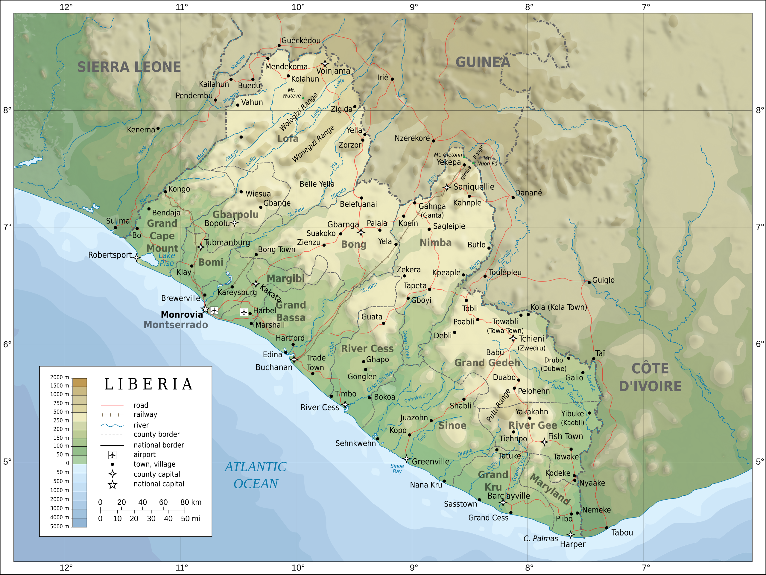
English: Topographic map of Liberia.
Français : Carte topographique du Liberia.
Suomi: Liberian topografinen kartta. |
| Date | |
| Soorce |
Self-made in Inkscape. Boundaries, rivers, roads, railroads, and place names based on a public domain United Nations map (Image:Un-liberia.png). Topography based on public domain GLOBE data from NOAA (http://www.ngdc.noaa.gov/mgg/topo/gltiles.html). Relief shading is an embedded PNG raster, derived from the GLOBE data using Perl. Bathymetry from NGDC ETOPO2. |
| Author | Oona Räisänen (Mysid) |
| Other versions |
Derivative works of this file: Railways in liberia-de.svg
|


|
This SVG file contains embedded text that can be translated into your language, using any capable SVG editor, text editor or the SVG Translate tool. For more information see: About translating SVG files. |
Licensin
I, the copyright holder of this work, hereby publish it under the following licenses:

|
Permission is grantit tae copy, distribute an/or modify this document unner the terms o the GNU Free Documentation License, Version 1.2 or ony later version published bi the Free Software Foundation; wi no Invariant Sections, no Front-Cover Texts, an no Back-Cover Texts. A copy o the license is includit in the section enteetled GNU Free Documentation License. |
This file is licensed under the Creative Commons Attribution-Share Alike 4.0 International, 3.0 Unported, 2.5 Generic, 2.0 Generic and 1.0 Generic license.
- Ye are free:
- tae share – tae copy, distribute an transmit the wirk
- tae remix – tae adapt the wirk
- Unner the follaein condeetions:
- attribution – Ye must attribute the wirk in the manner specified bi the author or licensor (but nae in ony way that suggests that thay endorse ye or yer uise o the wirk).
- share alik – If ye alter, transform, or big upon this wirk, ye mey distribute the resultin wirk anly unner the same or seemilar license tae this ane.
Ye mey select the license o yer choice.
File history
Clap oan ae date/time fer tae see the file aes it kithed at that time.
| Date/Time | Thummnail | Dimensions | Uiser | Comment | |
|---|---|---|---|---|---|
| current | 20:08, 31 Julie 2010 | | 3,148 × 2,363 (1.69 MB) | Mysid | remove the false "dropoff" from land to sea in shading |
| 20:02, 31 Julie 2010 |  | 3,148 × 2,363 (1.69 MB) | Mysid | fixed a couple of symbols + clipped the shading layer | |
| 10:49, 19 Julie 2010 |  | 3,148 × 2,363 (2.64 MB) | Mysid | argh, forgot to update legend box | |
| 10:41, 19 Julie 2010 |  | 3,148 × 2,363 (2.64 MB) | Mysid | revised for consistency with my other maps | |
| 12:46, 25 Mey 2008 |  | 3,148 × 2,363 (2.87 MB) | Mysid | border in image; layers in XML | |
| 18:34, 12 Mey 2008 |  | 3,037 × 2,257 (2.82 MB) | Mysid | adding lakes, airports, legends | |
| 16:44, 12 Mey 2008 |  | 3,037 × 2,257 (2.81 MB) | Mysid | == {{int:filedesc}} == {{Information |Description= {{en|Topographic map of Liberia.}} {{fr|Carte topographique du Liberia.}} {{fi|Liberian topografinen kartta.}} |Source=Self-made in Inkscape.<br/>Boundaries |
Eimage airtins
The'r nae pages airts tae this eimage.
Global file uisage
The follaein ither wikis uise this file:
- Uisage on ar.wikipedia.org
- Uisage on az.wikipedia.org
- Uisage on bcl.wikipedia.org
- Uisage on be-tarask.wikipedia.org
- Uisage on be.wikipedia.org
- Uisage on bn.wikipedia.org
- Uisage on ca.wikipedia.org
- Uisage on ckb.wikipedia.org
- Uisage on de.wikipedia.org
- Uisage on el.wikipedia.org
- Uisage on en.wikipedia.org
- Uisage on eu.wikipedia.org
- Uisage on fa.wikipedia.org
- Uisage on fi.wikipedia.org
- Uisage on fr.wikipedia.org
- Uisage on hr.wiktionary.org
- Uisage on hu.wikipedia.org
- Uisage on hy.wikipedia.org
- Uisage on id.wikipedia.org
- Uisage on io.wikipedia.org
- Uisage on is.wikipedia.org
- Uisage on it.wikipedia.org
- Uisage on ka.wikipedia.org
- Uisage on lt.wikipedia.org
- Uisage on mzn.wikipedia.org
- Uisage on nds.wikipedia.org
- Uisage on nl.wikipedia.org
- Uisage on pl.wikipedia.org
- Uisage on ps.wikipedia.org
View mair global usage o this file.