
File:Sparta territory.jpg
Size o this luikower: 654 × 599 pixels. Ither resolutions: 262 × 240 pixels | 524 × 480 pixels | 743 × 681 pixels.
Oreeginal file (743 × 681 pixels, file size: 201 KB, MIME type: image/jpeg)
Ootline
| Descreeption |
Русский: территория спарты
Čeština: Území starověké Sparty
Deutsch: Landkarte von Sparta
Nederlands: gebied |
| Date |
|
| Soorce |
Ain wirk |
| Author |
Marsyas |
| Other versions | {.svg |

|
File:Sparta Territory.svg is a vector version o this file. It should be uised in place o this raster image when nae inferior.
File:Sparta territory.jpg → File:Sparta Territory.svg
For mair information, see Help:SVG. |
 |
|Description=
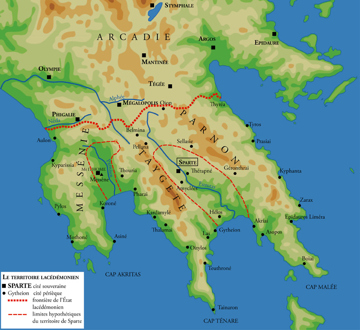
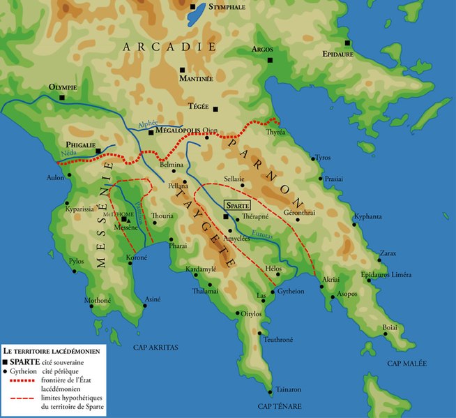
Português: Território de Esparta na época clássica. Kaplan (dir.), Le Monde grec, Paris, 1995, p. 93.
Català: Territori de l'antiga Esparta.'
Čeština: Území starověké Sparty
Deutsch: Gebiet des antiken Spartas. Aus: Le Monde grec, Paris 1995, S. 93.
English: Territory of ancient Sparta. Data from Kaplan (dir.), Le Monde grec, Paris, 1995, p. 93.
Español: Territorio de Esparta en la época clásica. Kaplan (dir.), Le Monde grec, Paris, 1995, p. 93.
Suomi: Sparta klassisella ajalla. Paksu viiva: Sparta ja valloitetut alueet, ohut viiva: varsinaisen Spartan kaupungin arvioitu alue. Kartan esittämän alueen leveys luonnossa on noin 150 km.
Français : Territoire de Sparte à la période classique. Données issues de Kaplan (dir.), Le Monde grec, Paris, 1995, p. 93.
Magyar: A spártai állam, Lakedaimón és Messzénia.
Italiano: Territorio di Sparta in età classica
Norsk bokmål: Spartas territorium
Română: Teritoriul Spartei in perioada clasica. Informatii din Kaplan (dir.), Le Monde grec, Paris, 1995, p. 93.
Русский: Территория Спарты
|Source=Ain wirk |Author=Marsyas |Date=2005-01-22 |Permission=

|
Permission is grantit tae copy, distribute an/or modify this document unner the terms o the GNU Free Documentation License, Version 1.2 or ony later version published bi the Free Software Foundation; wi no Invariant Sections, no Front-Cover Texts, an no Back-Cover Texts. A copy o the license is includit in the section enteetled GNU Free Documentation License. |
| This file is licensed unner the Creative Commons Attribution-Share Alike 3.0 Unported license. | ||
| ||
| This licensing tag was added to this file as part of the GFDL licensing update. |
}}
File history
Clap oan ae date/time fer tae see the file aes it kithed at that time.
| Date/Time | Thummnail | Dimensions | Uiser | Comment | |
|---|---|---|---|---|---|
| current | 17:58, 22 Januar 2005 | | 743 × 681 (201 KB) | Marsyas |
Eimage airtins
The follaein pages airts tae this image:
Global file uisage
The follaein ither wikis uise this file:
- Uisage on als.wikipedia.org
- Uisage on ar.wikipedia.org
- Uisage on arz.wikipedia.org
- Uisage on ast.wikipedia.org
- Uisage on ba.wikipedia.org
- Uisage on be-tarask.wikipedia.org
- Uisage on be.wikipedia.org
- Uisage on bg.wikipedia.org
- Uisage on br.wikipedia.org
- Uisage on bs.wikipedia.org
- Uisage on ca.wikipedia.org
- Uisage on ceb.wikipedia.org
- Uisage on cs.wikipedia.org
- Uisage on cv.wikipedia.org
- Uisage on de.wikipedia.org
- Uisage on el.wikipedia.org
- Uisage on en.wikipedia.org
- User:Mitternacht90
- Portal:Ancient Greece/Selected location
- Portal:Ancient Greece/Selected location/2
- Portal:Ancient Greece/DYK
- Portal:Ancient Greece/DYK/8
- Thouria, Messenia
- User:Peenut2k7
- List of ancient great powers
- User:Chickstarr404/Gather lists/9320 – Mani by Leigh Patrick Fermor
- Pausanias (king of Sparta)
- Uisage on en.wiktionary.org
- Uisage on eo.wikipedia.org
- Uisage on es.wikipedia.org
- Uisage on et.wikipedia.org
- Uisage on eu.wikipedia.org
View mair global usage o this file.