
File:North yorkshire moors railway map.gif
Size o this luikower: 800 × 593 pixels. Ither resolutions: 320 × 237 pixels | 640 × 474 pixels | 1,024 × 759 pixels | 1,198 × 888 pixels.
Oreeginal file (1,198 × 888 pixels, file size: 73 KB, MIME type: image/gif)
| Descreeption |
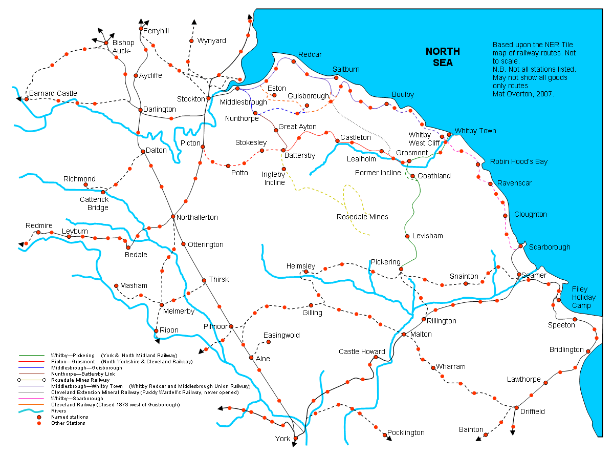
English: Map of former and existing railway lines across the North Yorkshire Moors, Mat Overton, 2006 |
| Date | 30 Mairch 2007 (original upload date) |
| Soorce | Transferred from en.wikipedia to Commons by Oxyman using CommonsHelper. |
| Author | Original uploader was Maniac Pony (talk) at en.wikipedia |
Licensin
Maniac Pony, the copyright holder of this work, hereby publishes it under the following licenses:
| This file is licensed unner the Creative Commons Attribution-Share Alike 3.0 Unported license. Subject to disclaimers. | ||
| Attribution: Maniac Pony | ||
| ||
| This licensing tag was added to this file as part of the GFDL licensing update. |

|
Permission is grantit tae copy, distribute an/or modify this document unner the terms o the GNU Free Documentation License, Version 1.2 or ony later version published bi the Free Software Foundation; wi no Invariant Sections, no Front-Cover Texts, an no Back-Cover Texts. A copy o the license is includit in the section enteetled GNU Free Documentation License. Subject to disclaimers. |
This file is licensed under the Creative Commons Attribution 2.5 Generic license.
Attribution: Maniac Pony
- Ye are free:
- tae share – tae copy, distribute an transmit the wirk
- tae remix – tae adapt the wirk
- Unner the follaein condeetions:
- attribution – Ye must attribute the wirk in the manner specified bi the author or licensor (but nae in ony way that suggests that thay endorse ye or yer uise o the wirk).
Ye mey select the license o yer choice.
Original upload log
The original description page was here. All following user names refer to en.wikipedia.
- 2007-03-30 08:19 Achmelvic 1198×888× (74418 bytes) Moved Northallerton name to correct position
- 2007-03-17 11:14 Maniac Pony 1198×888× (75557 bytes) Map of former and existing railway lines across the North Yorkshire Moors and surrounding area, Mat Overton, 2007
- 2007-03-12 19:43 Maniac Pony 1133×838× (71220 bytes) Map of former and existing railway lines across the North Yorkshire Moors, Mat Overton, 2006 - 2007
- 2006-12-30 19:43 Maniac Pony 921×590× (25882 bytes) Map of former and existing railway lines across the North Yorkshire Moors, Mat Overton, 2006
- 2006-12-30 19:41 Maniac Pony 921×590× (25882 bytes) Map of former and existing railway lines across the North Yorkshire Moors, Mat Overton, 2006
- 2006-12-30 19:40 Maniac Pony 921×590× (25882 bytes) Map of former and existing railway lines across the North Yorkshire Moors, Mat Overton, 2006
- 2006-12-30 19:39 Maniac Pony 921×590× (25882 bytes) Map of former and existing railway lines across the North Yorkshire Moors, Mat Overton, 2006
- 2006-12-10 13:57 Maniac Pony 938×573× (25565 bytes) Map of former and existing railway lines across the North Yorkshire Moors, Mat Overton, 2006
File history
Clap oan ae date/time fer tae see the file aes it kithed at that time.
| Date/Time | Thummnail | Dimensions | Uiser | Comment | |
|---|---|---|---|---|---|
| current | 14:04, 19 November 2010 | | 1,198 × 888 (73 KB) | Prioryman | Corrected date of closure of Cleveland Railway line west of Guisborough (1873 not 1866) |
| 23:15, 7 Julie 2009 |  | 1,198 × 888 (73 KB) | File Upload Bot (Magnus Manske) | {{BotMoveToCommons|en.wikipedia|year={{subst:CURRENTYEAR}}|month={{subst:CURRENTMONTHNAME}}|day={{subst:CURRENTDAY}}}} {{Information |Description={{en|Map of former and existing railway lines across the North Yorkshire Moors, Mat Overton, 2006 [[:en:Cat |
Eimage airtins
The follaein pages airts tae this image:
Global file uisage
The follaein ither wikis uise this file:
- Uisage on en.wikipedia.org
- Uisage on ru.wikipedia.org
- Uisage on www.wikidata.org