
File:Kyrenia 01-2017 img04 view from castle bastion.jpg

Size o this luikower: 800 × 500 pixels. Ither resolutions: 320 × 200 pixels | 640 × 400 pixels | 1,024 × 640 pixels | 1,280 × 800 pixels | 2,560 × 1,600 pixels | 4,582 × 2,864 pixels.
Oreeginal file (4,582 × 2,864 pixels, file size: 5.35 MB, MIME type: image/jpeg)
| Descreeption |
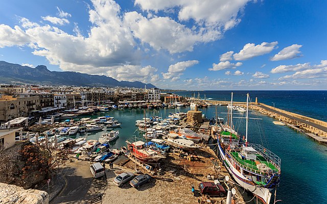
English: View of the old harbour from the castle in Kyrenia, Cyprus
Русский: Вид на старый порт с бастиона крепости в Киринии, Кипр
|
| Date | |
| Soorce | Ain wirk |
| Author | A.Savin |
| Permission (Reuisin this file) |
.svg) Just attribute the author: «A.Savin, Wikipedia»; if you have questions — Telegram, or e-mail to wikiphotospace@gmail.com..svg) Просто укажите в качестве автора: «А.Савин, Википедия»; если есть вопрос — телеграм, или эл.почта на wikiphotospace@gmail.com. Kennzeichnen Sie einfach als Autor: «A.Savin, Wikipedia»; falls Sie Fragen haben — Telegram, oder E-Mail an wikiphotospace@gmail.com.
Thank you. |
| Camera location | | View this and other nearby images on: OpenStreetMap |
|---|
|
This image was selected as picture of the day on Wikimedia Commons for 9 January 2019. It was captioned as follows: Other languages:
|
Licensin
| Copyleft: This wairk o airt is free; ye can redistreebute it n/or modifie it accordin til the terms o the Free Art License. Ye'll fynd ae specimen o this license oan the Copyleft Attitude steid aes weel aes oan ither steids. |
File history
Clap oan ae date/time fer tae see the file aes it kithed at that time.
| Date/Time | Thummnail | Dimensions | Uiser | Comment | |
|---|---|---|---|---|---|
| current | 16:28, 24 Februar 2017 | | 4,582 × 2,864 (5.35 MB) | A.Savin | {{User:A.Savin/F |Description= {{en|View of the old harbour from the castle in Kyrenia, Cyprus}} {{ru|Вид на старый порт с бастиона крепости в Киринии, Кипр}} |Year=2017 |Country=Cyprus |Month=01 |Day=09}} {{... |
Eimage airtins
The follaein pages airts tae this image:
Global file uisage
The follaein ither wikis uise this file:
- Uisage on ar.wikipedia.org
- Uisage on arz.wikipedia.org
- Uisage on az.wikipedia.org
- Uisage on be-tarask.wikipedia.org
- Uisage on be.wikipedia.org
- Uisage on bg.wikipedia.org
- Uisage on ca.wikipedia.org
- Uisage on ceb.wikipedia.org
- Uisage on crh.wikipedia.org
- Uisage on cs.wikipedia.org
- Uisage on cv.wikipedia.org
- Uisage on de.wikivoyage.org
- Uisage on diq.wikipedia.org
- Uisage on el.wikipedia.org
- Uisage on en.wikipedia.org
- Uisage on en.wikivoyage.org
- Uisage on eo.wikipedia.org
- Uisage on es.wikipedia.org
- Uisage on es.wikivoyage.org
- Uisage on eu.wikipedia.org
- Uisage on fa.wikipedia.org
- Uisage on fi.wikipedia.org
- Uisage on frp.wikipedia.org
- Uisage on fr.wikipedia.org
- Uisage on fr.wikivoyage.org
- Uisage on he.wikivoyage.org
View mair global usage o this file.