
File:Han Dynasty Plain map.PNG
Size o this luikower: 800 × 352 pixels. Ither resolutions: 320 × 141 pixels | 640 × 282 pixels | 1,427 × 628 pixels.
Oreeginal file (1,427 × 628 pixels, file size: 48 KB, MIME type: image/png)
Ootline
| Descreeption |
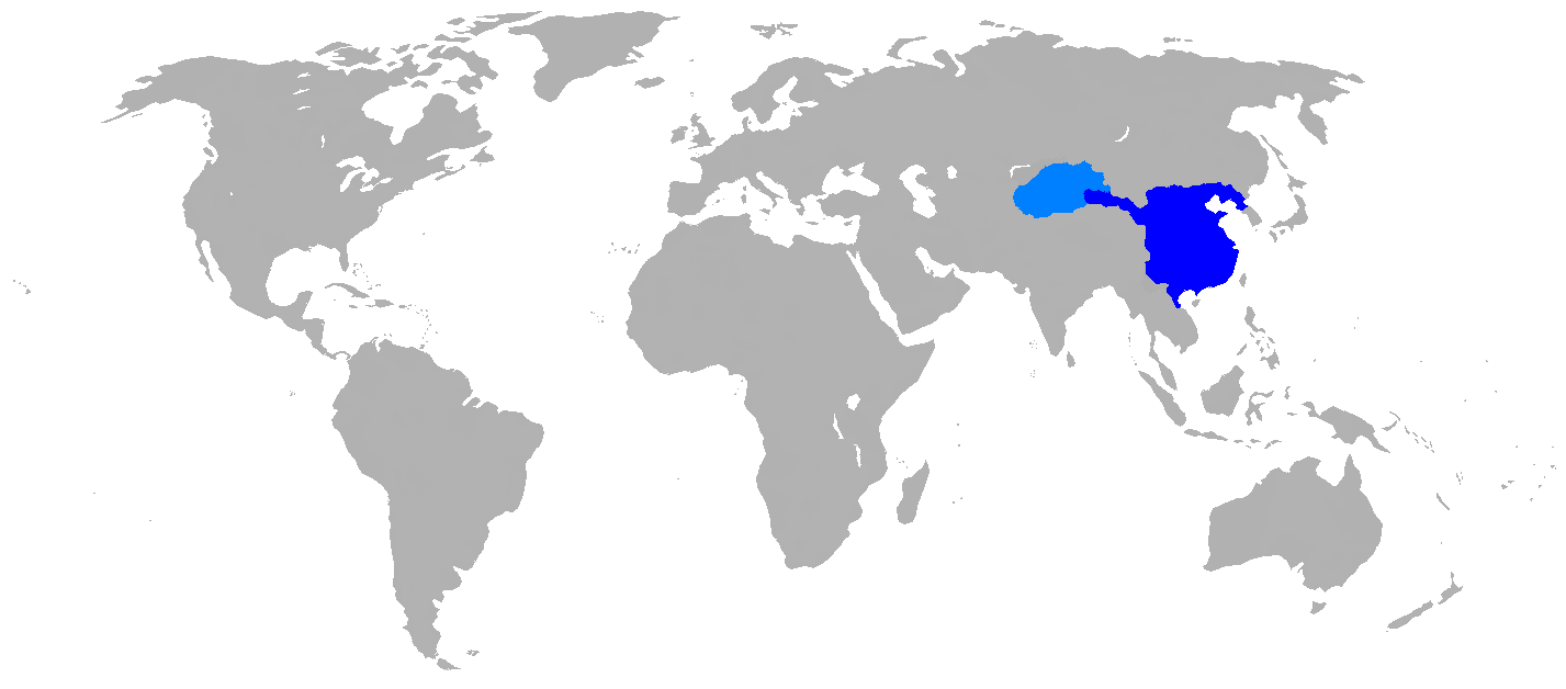
English: Map of Han Dynasty in 2 CE.
|
| Date | |
| Soorce | Self Made, copied map from page 63 of the book Mapping History: World History (London: Cartographica, 2007), by Dr. Ian Barnes. ISBN 978-1-84573-323-0 |
| Author | User:Historian of the arab people |
Licensin
| I, the copyright holder of this work, release this work into the public domain. This applies worldwide. In some countries this may not be legally possible; if so: I grant anyone the right to use this work for any purpose, without any conditions, unless such conditions are required by law. |
File history
Clap oan ae date/time fer tae see the file aes it kithed at that time.
| Date/Time | Thummnail | Dimensions | Uiser | Comment | |
|---|---|---|---|---|---|
| current | 14:37, 26 Apryle 2016 | | 1,427 × 628 (48 KB) | Garam | Clear (* ref: File:China Han Dynasty 1.jpg and File:Hangunhyeon.PNG) |
| 23:58, 29 October 2008 |  | 1,427 × 628 (59 KB) | Historian of the arab people | {{Information |Description={{en|1=Map of Han dynasty, 2 AD Darkest blue is the commandaries and principalities of the Han Empire, light blue is the Tarim Basin protectorate}} |Source=Self Made, copied map from page 63 of the book, "MAPPING HISTORY WORLD H |
Eimage airtins
The follaein pages airts tae this image:
Global file uisage
The follaein ither wikis uise this file:
- Uisage on ar.wikipedia.org
- Uisage on as.wikipedia.org
- Uisage on azb.wikipedia.org
- Uisage on de.wikipedia.org
- Uisage on en.wikipedia.org
- Uisage on et.wikipedia.org
- Uisage on fi.wikipedia.org
- Uisage on fo.wikipedia.org
- Uisage on he.wikipedia.org
- Uisage on id.wikipedia.org
- Uisage on pnb.wikipedia.org
- Uisage on ur.wikipedia.org