
File:Golan Heights relief v2.png

Size o this luikower: 522 × 600 pixels. Ither resolutions: 209 × 240 pixels | 418 × 480 pixels | 758 × 871 pixels.
Oreeginal file (758 × 871 pixels, file size: 923 KB, MIME type: image/png)
Ootline
| Descreeption |
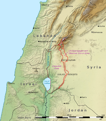
English: This is a shaded relief map illustrating the topography of the Golan Heights and surrounding areas. Transverse Mercator projection (EPSG: 2039) Source data: * Elevation data: SRTM data from NASA[1] * Borders, cities, and geographic features: The Natural Earth
العربية: هذه خريطة مجسمة مظللة توضح تضاريس هضبة الجولان والمناطق المحيطة بها ومآل مناطق النزاع على الحدود بين سوريا وإسرائيل. الإحداثيات حسب نظام إسقاط ميركاتور المستعرض (EPSG: 2039)
مصدر البيانات:
|
| Date | (UTC) |
| Soorce | |
| Author |
|
| Other versions | File:Golan Heights geography.png |

|
This map image could be re-created using vector graphics as an SVG file. This has several advantages; see Commons:Media for cleanup for more information. If an SVG form of this image is available, please upload it and afterwards replace this template with
{{vector version available|new image name}}.
It is recommended to name the SVG file “Golan Heights relief v2.svg”—then the template Vector version available (or Vva) does not need the new image name parameter. |
| This is a retouched picture, which means that it has been digitally altered from its original version. Modifications: Adjusted borders to prioritise internationally recognised borders.. The original can be viewed here: Golan Heights relief v1.jpg:
|
Licensin
I, the copyright holder of this work, hereby publish it under the following licenses:
This file is licensed unner the Creative Commons Attribution-Share Alike 3.0 Unported license.
- Ye are free:
- tae share – tae copy, distribute an transmit the wirk
- tae remix – tae adapt the wirk
- Unner the follaein condeetions:
- attribution – Ye must attribute the wirk in the manner specified bi the author or licensor (but nae in ony way that suggests that thay endorse ye or yer uise o the wirk).
- share alik – If ye alter, transform, or big upon this wirk, ye mey distribute the resultin wirk anly unner the same or seemilar license tae this ane.

|
Permission is grantit tae copy, distribute an/or modify this document unner the terms o the GNU Free Documentation License, Version 1.2 or ony later version published bi the Free Software Foundation; wi no Invariant Sections, no Front-Cover Texts, an no Back-Cover Texts. A copy o the license is includit in the section enteetled GNU Free Documentation License. |
Ye mey select the license o yer choice.
Original upload log
This image is a derivative work of the following images:
- File:Golan_Heights_relief_v1.jpg licensed with Cc-by-sa-3.0, GFDL
- 2011-03-15T03:27:39Z Kbh3rd 758x871 (279344 Bytes) With "Golan Heights" labeled, from original layers to avoid quality issues with Chesdovi's edit
- 2011-03-09T15:33:27Z Chesdovi 615x605 (161970 Bytes) Adding GOLAN HEIGHTS wording
- 2011-01-24T03:44:15Z Kbh3rd 758x871 (278034 Bytes) {{Information |Description ={{en|1=This is a [[:en:shaded relief|shaded relief]] map illustrating the topography of the [[:en:Golan Heights|Golan Heights]] and surrounding areas. Transverse Mercator projection (EPSG: 2039
Uploaded with derivativeFX
File history
Clap oan ae date/time fer tae see the file aes it kithed at that time.
| Date/Time | Thummnail | Dimensions | Uiser | Comment | |
|---|---|---|---|---|---|
| current | 06:27, 29 November 2011 | | 758 × 871 (923 KB) | Night w | == {{int:filedesc}} == {{Information |Description={{en|1=This is a shaded relief map illustrating the topography of the Golan Heights and surrounding areas. Transverse Mercator projection (EPSG: |
Eimage airtins
The follaein pages airts tae this image:
Global file uisage
The follaein ither wikis uise this file:
- Uisage on ar.wikipedia.org
- Uisage on ca.wikipedia.org
- Uisage on ceb.wikipedia.org
- Uisage on de.wikipedia.org
- Uisage on el.wikipedia.org
- Uisage on en.wikipedia.org
- Uisage on eo.wikipedia.org
- Uisage on es.wikipedia.org
- Uisage on eu.wikipedia.org
- Uisage on fa.wikipedia.org
- Uisage on fr.wikipedia.org
- Uisage on hi.wikibooks.org
- Uisage on hu.wikipedia.org
- Uisage on hyw.wikipedia.org
- Uisage on id.wikipedia.org
- Uisage on it.wikipedia.org
- Uisage on ja.wikipedia.org
- Uisage on kn.wikipedia.org
- Uisage on ml.wikipedia.org
- Uisage on nl.wikipedia.org
- Uisage on os.wikipedia.org
- Uisage on pt.wikipedia.org
- Uisage on ru.wikipedia.org
View mair global usage o this file.