
File:Costa Rica relief location map.jpg

Size o this luikower: 666 × 600 pixels. Ither resolutions: 267 × 240 pixels | 533 × 480 pixels | 853 × 768 pixels | 1,148 × 1,034 pixels.
Oreeginal file (1,148 × 1,034 pixels, file size: 841 KB, MIME type: image/jpeg)
Ootline
| Camera location | | View this and other nearby images on: OpenStreetMap |
|---|
| Descreeption |
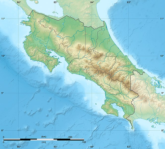
English: Blank relief map of Costa Rica for geo-location purpose.
Note : The Isla del Coco, out of the map, is not shown. Scale : 1:1,856,000 (accuracy : 464 m) Français : Carte du relief vierge du Costa Rica destinée à la géolocalisation.
Note : L´Isla del Coco, hors carte, n'est pas représentée. Échelle : 1:1 856 000 (précision : 464 m) Equirectangular projection centered on 9° 30' N – 84° 15' W, WGS84 datum * West : 86° 30' W * East : 82° W * North : 11° 30' N * South : 7° 30' N |
||
| Date | 2008-06, updated 2022-03 | ||
| Soorce |
Ain wirk
|
||
| Author | Eric Gaba (Sting - fr:Sting) | ||
| Permission (Reuisin this file) |
|
||
| Other versions |
|

Licensin
Eric Gaba (user Sting) for Wikimedia Commons using GEBCO_2021 Grid data, the copyright holder of this work, hereby publishes it under the following licenses:

|
Permission is grantit tae copy, distribute an/or modify this document unner the terms o the GNU Free Documentation License, Version 1.2 or ony later version published bi the Free Software Foundation; wi no Invariant Sections, no Front-Cover Texts, an no Back-Cover Texts. A copy o the license is includit in the section enteetled GNU Free Documentation License. |
This file is licensed under the Creative Commons Attribution-Share Alike 4.0 International, 3.0 Unported, 2.5 Generic, 2.0 Generic and 1.0 Generic license.
Attribution: Eric Gaba (user Sting) for Wikimedia Commons using GEBCO_2021 Grid data
- Ye are free:
- tae share – tae copy, distribute an transmit the wirk
- tae remix – tae adapt the wirk
- Unner the follaein condeetions:
- attribution – Ye must attribute the wirk in the manner specified bi the author or licensor (but nae in ony way that suggests that thay endorse ye or yer uise o the wirk).
- share alik – If ye alter, transform, or big upon this wirk, ye mey distribute the resultin wirk anly unner the same or seemilar license tae this ane.
Ye mey select the license o yer choice.
File history
Clap oan ae date/time fer tae see the file aes it kithed at that time.
| Date/Time | Thummnail | Dimensions | Uiser | Comment | |
|---|---|---|---|---|---|
| current | 22:51, 30 Mairch 2022 | | 1,148 × 1,034 (841 KB) | Sting | New map using new data |
| 01:32, 4 November 2021 |  | 1,148 × 1,034 (906 KB) | RoboQwezt0x7CB | hand edited to remove non-existing waterbodies, used lower elevation green shade to bucket fill (best I can do without the tools to generate the map) particulary in the south of the country (probably an altitude render/clipping error), kept some that are hydroelectric plant's reservoirs | |
| 12:11, 19 Julie 2010 |  | 1,148 × 1,034 (500 KB) | Sting | Color profile | |
| 15:05, 30 Julie 2008 |  | 1,148 × 1,034 (491 KB) | Sting | - border | |
| 14:40, 13 Juin 2008 |  | 1,148 × 1,034 (499 KB) | Sting | Several improvements | |
| 01:21, 12 Juin 2008 |  | 1,148 × 1,034 (501 KB) | Sting | Correction on shaded layer | |
| 01:09, 12 Juin 2008 |  | 1,148 × 1,034 (504 KB) | Sting | == Summary == {{Location|10|00|00|N|84|00|00|W|scale:2000000}} <br/> {{Information |Description={{en|Blank relief map of Costa Rica for geo-location purpose.<br/>''Note :'' The ''Isla del Coco'', out of the map, is not shown.<br/>Scale |
Eimage airtins
The follaein pages airts tae this image:
Global file uisage
The follaein ither wikis uise this file:
- Uisage on ar.wikipedia.org
- Uisage on ast.wikipedia.org
- Uisage on azb.wikipedia.org
- Uisage on az.wikipedia.org
- Uisage on ban.wikipedia.org
- Uisage on ba.wikipedia.org
- Uisage on be.wikipedia.org
- Uisage on bg.wikipedia.org
- Uisage on bn.wikipedia.org
- Uisage on bs.wikipedia.org
- Uisage on ca.wikipedia.org
- Uisage on ceb.wikipedia.org
- Uisage on ce.wikipedia.org
- Uisage on ckb.wikipedia.org
- Uisage on cs.wikipedia.org
View mair global usage o this file.