File:Ausstellungsgebäude Mathildenhöhe-Kuppel.jpg

Oreeginal file (2,000 × 2,000 pixels, file size: 5.02 MB, MIME type: image/jpeg)
This file is fae Wikimedia Commons n micht be uised bi ither waurks. The descreeption oan its file descreeption page thaur is shawn ablo.
Ootline
| DescreeptionAusstellungsgebäude Mathildenhöhe-Kuppel.jpg |
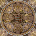
Deutsch: Deckenmosaik in der Kuppel über dem Aufgang zum Ausstellungsgebäude auf der Mathildenhöhe, Darmstadt.
Das Mosaik wurde von der Mosaikfirma Simon Theodor Rauecker aus München nach Entwürfen Olbrichs ausgeführt. Es zeigt das Emblem des Hessischen Löwen. Ein schmaler umlaufender Fries trägt ein Zitat des darmstädter Großherzogs Ernst Ludwig:
English: Roof mosaic, exhibition building, Mathildenhöhe, Darmstadt |
| Date | |
| Soorce | Ain wirk MartinKraft.com |
| Author | Martin Kraft |
| Permission (Reuisin this file) |
Reusing this image License: CC BY-SA 3.0 via Wikimedia Commons This image was published by Martin Kraft under the free license CC BY-SA 3.0, which also allows the usage outside of Wikipedia under the following conditions:
Please send me a specimen copy or the URL of the website where the image is used. The Online Attribution Generator offers a good tool to generate an attribution sufficient for your use case. Feel free to contact me via eMail photo@martinkraft.com or visit my website photo.martinkraft.com for any questions or in case you need...
Only the terms and conditions mentioned above authorize the free use of this image. Any infringement causes a copyright violation, that may result in a penalty fee of five times the fee suggested by the MFM, inter alia. |
| Camera location | 49° 52′ 35.57″ N, 8° 40′ 03.12″ E | View this and other nearby images on: OpenStreetMap |
|---|
Licensin
| Copyleft: This wairk o airt is free; ye can redistreebute it n/or modifie it accordin til the terms o the Free Art License. Ye'll fynd ae specimen o this license oan the Copyleft Attitude steid aes weel aes oan ither steids. http://artlibre.org/licence/lal/enFALFree Art Licensefalsetrue |

|
Permission is grantit tae copy, distribute an/or modify this document unner the terms o the GNU Free Documentation License, Version 1.2 or ony later version published bi the Free Software Foundation; wi no Invariant Sections, no Front-Cover Texts, an no Back-Cover Texts. A copy o the license is includit in the section enteetled GNU Free Documentation License.http://www.gnu.org/copyleft/fdl.htmlGFDLGNU Free Documentation Licensetruetrue |
- Ye are free:
- tae share – tae copy, distribute an transmit the wirk
- tae remix – tae adapt the wirk
- Unner the follaein condeetions:
- attribution – Ye must attribute the wirk in the manner specified bi the author or licensor (but nae in ony way that suggests that thay endorse ye or yer uise o the wirk).
- share alik – If ye alter, transform, or big upon this wirk, ye mey distribute the resultin wirk anly unner the same or seemilar license tae this ane.


|
This image has been assessed using the Quality image guidelines and is considered a Quality image.
العربية ∙ جازايرية ∙ беларуская ∙ беларуская (тарашкевіца) ∙ български ∙ বাংলা ∙ català ∙ čeština ∙ Cymraeg ∙ Deutsch ∙ Schweizer Hochdeutsch ∙ Zazaki ∙ Ελληνικά ∙ English ∙ Esperanto ∙ español ∙ eesti ∙ euskara ∙ فارسی ∙ suomi ∙ français ∙ galego ∙ עברית ∙ हिन्दी ∙ hrvatski ∙ magyar ∙ հայերեն ∙ Bahasa Indonesia ∙ italiano ∙ 日本語 ∙ Jawa ∙ ქართული ∙ 한국어 ∙ kurdî ∙ Lëtzebuergesch ∙ lietuvių ∙ македонски ∙ മലയാളം ∙ मराठी ∙ Bahasa Melayu ∙ Nederlands ∙ Norfuk / Pitkern ∙ polski ∙ português ∙ português do Brasil ∙ rumantsch ∙ română ∙ русский ∙ sicilianu ∙ slovenčina ∙ slovenščina ∙ shqip ∙ српски / srpski ∙ svenska ∙ தமிழ் ∙ తెలుగు ∙ ไทย ∙ Tagalog ∙ Türkçe ∙ toki pona ∙ українська ∙ vèneto ∙ Tiếng Việt ∙ 中文 ∙ 中文(简体) ∙ 中文(繁體) ∙ +/− |
Captions
Items portrayed in this file
depicts
copyright status Inglis
copyrighted Inglis
6 October 2013
source of file Inglis
49°52'35.569"N, 8°40'3.122"E
image/jpeg
checksum Inglis
2330f948c0c439ae1971571c026b2421f2868be6
data size Inglis
5,259,063 byte
2,000 pixel
width Inglis
2,000 pixel
File history
Clap oan ae date/time fer tae see the file aes it kithed at that time.
| Date/Time | Thummnail | Dimensions | Uiser | Comment | |
|---|---|---|---|---|---|
| current | 22:52, 4 Januar 2014 |  | 2,000 × 2,000 (5.02 MB) | Martin Kraft |
Eimage airtins
The'r nae pages airts tae this eimage.
Global file uisage
The follaein ither wikis uise this file:
- Uisage on de.wikipedia.org
- Uisage on meta.wikimedia.org
Metadata
This file contains addeetional information, likelie eikit fae the deegital camera or scanner uised tae cræft or deegitise it.
Gif the file haes bin modeefied fae its oreeginal state, some details micht na fullie reflect the modeefied file.
| Copyricht hauder |
|
|---|---|
| Uníque ID o oreeginal document | 6AC7E6832F1CD9007D51FDBE6A0F5282 |
| Saffware uised | Adobe Photoshop CS6 Windows |
| Writer | Martin Kraft // Photographie |
| IIM version | 2 |
