
File:Aerial view of Wells.jpg
Nae heier resolution available.
Aerial_view_of_Wells.jpg (640 × 427 pixels, file size: 217 KB, MIME type: image/jpeg)
| Descreeption |
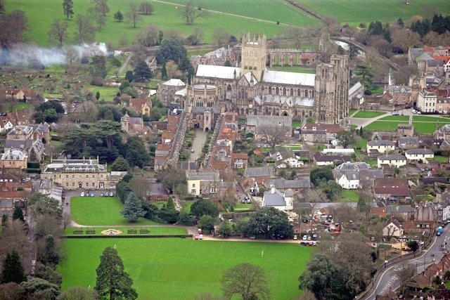
English: Aerial view of Wells Cathedral and the cathedral precinct including Vicars' Close and Wells Cathedral School. |
| Date | |
| Soorce |
This file was derived from: Aerial View of Wells Cathedral - geograph.org.uk - 526211.jpg |
| Author | Pete Penfold |
| Other versions | File:Aerial view of Wells-crop.jpg |
| Attribution (required by the license) | Pete Penfold / Aerial View of Wells Cathedral / |
| Camera location | | View this and other nearby images on: OpenStreetMap |
|---|
_heading:157.00&language=sco)
| Object location | | View this and other nearby images on: OpenStreetMap |
|---|
_heading:157.00&language=sco)
This file is licensed under the Creative Commons Attribution-Share Alike 2.0 Generic license.
Attribution: Pete Penfold
- Ye are free:
- tae share – tae copy, distribute an transmit the wirk
- tae remix – tae adapt the wirk
- Unner the follaein condeetions:
- attribution – Ye must attribute the wirk in the manner specified bi the author or licensor (but nae in ony way that suggests that thay endorse ye or yer uise o the wirk).
- share alik – If ye alter, transform, or big upon this wirk, ye mey distribute the resultin wirk anly unner the same or seemilar license tae this ane.
| This is a retouched picture, which means that it has been digitally altered from its original version. Modifications: White balance and brightness adjusted. The original can be viewed here: Aerial View of Wells Cathedral - geograph.org.uk - 526211.jpg:
|
File history
Clap oan ae date/time fer tae see the file aes it kithed at that time.
| Date/Time | Thummnail | Dimensions | Uiser | Comment | |
|---|---|---|---|---|---|
| current | 07:14, 17 Mairch 2010 | | 640 × 427 (217 KB) | Wine Guy | {{Information |Description={{en|1=Aerial view of Wells Cathedral and the cathedral precinct including Vicars' Close and Wells Cathedral School.}} |Source=http://www.geogra |
Eimage airtins
The follaein pages airts tae this image:
Global file uisage
The follaein ither wikis uise this file:
- Uisage on bn.wiktionary.org
- Uisage on en.wikipedia.org
- Uisage on en.wiktionary.org
- Uisage on es.wikipedia.org
- Uisage on eu.wikipedia.org
- Uisage on fa.wikipedia.org
- Uisage on fi.wikipedia.org
- Uisage on fr.wikipedia.org
- Uisage on hy.wikipedia.org
- Uisage on id.wikipedia.org
- Uisage on is.wikipedia.org
- Uisage on ja.wikipedia.org
- Uisage on ko.wikipedia.org
- Uisage on la.wikipedia.org
- Uisage on ms.wikipedia.org
- Uisage on mt.wikipedia.org
- Uisage on nn.wikipedia.org
- Uisage on no.wikipedia.org
- Uisage on pnb.wikipedia.org
- Uisage on pt.wikipedia.org
- Uisage on ro.wikipedia.org
- Uisage on ru.wikipedia.org
- Uisage on sl.wikipedia.org
- Uisage on sr.wikipedia.org
- Uisage on th.wikipedia.org
- Uisage on th.wiktionary.org
- Uisage on tr.wikipedia.org
- Uisage on ur.wikipedia.org
- Uisage on uz.wikipedia.org
- Uisage on war.wikipedia.org
- Uisage on yi.wikipedia.org
- Uisage on zh.wikipedia.org