
File:5500vc ex leg.jpg
Size o this luikower: 494 × 600 pixels. Ither resolutions: 198 × 240 pixels | 500 × 607 pixels.
Oreeginal file (500 × 607 pixels, file size: 170 KB, MIME type: image/jpeg)
Ootline
{
| Descreeption |
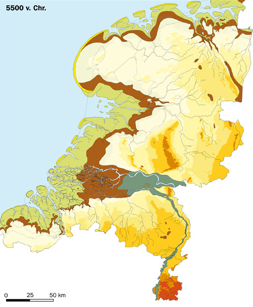
English: Palaeogeography of the Netherlands 5500 BC.
Dune and Beach ridge
Bogs, peat marshes, floodplain silt areas and basins of large rivers (including old river courses and riverbank breaches which have filled up with silt or peat)
Valley of large rivers (not covered with peat)
River dune (Pleistocene dunes)
Pleistocene landscape (> -6 m relative to NAP)
Pleistocene landscape ( -6 m - 0 m)
Pleistocene landscape ( 0 m - 10 m)
Pleistocene landscape( 10 m - 20 m)
Pleistocene landscape ( 20 m - 50 m)
Pleistocene landscape ( 50 m - 100 m)
Pleistocene landscape ( 100 m - 200 m)
Nederlands: Paleogeografie van Nederland rond 5500 voor Christus.
Dal van de grote rivieren (niet overveend)
Rivierduinen (donken)
Pleistoceen landschap (> -6 m t.o.v. NAP)
Pleistoceen landschap ( -6 m - 0 m)
Pleistoceen] landschap( 0 m - 10 m)
Pleistoceen landschap ( 10 m - 20 m)
Pleistoceen landschap ( 20 m - 50 m)
Pleistoceen landschap ( 50 m - 100 m)
Pleistoceen landschap ( 100 m - 200 m)
Français : Paléogéographie des Pays-Bas vers 5500 ans avant Jésus-Christ.
Tourbières, bassins des grandes rivières et lit majeur (y compris les anciens cours d'eau et les brèches dans les berges qui se sont remplies de limon ou de tourbe.)
Vallée des grandes rivières (non recouvert de tourbe)
Dunes fluviales
Paysage pléistocène (> -6 m par rapport au NAP)
Paysage pléistocène ( -6 m - 0 m)
Paysage pléistocène ( 0 m - 10 m)
Paysage pléistocène ( 10 m - 20 m)
Paysage pléistocène ( 20 m - 50 m)
Paysage pléistocène ( 50 m - 100 m)
Paysage pléistocène ( 100 m - 200 m)
|
||
| Date | |||
| Soorce | RACM & TNO. Developed for the Nationale Onderzoeksagenda Archeologie www.noaa.nl | ||
| Author | RACM & TNO | ||
| Permission (Reuisin this file) |
Nederlands: Geachte heer Klein,
U heeft gevraagd om het gebruik van de nieuwe paleogeografische kaarten van Nederland voor Wikipedia. Namens de RACM, rechthebende op de afbeeldingen, sta ik u toe deze afbeeldingen te gebruiken onder de GFDL licentie. Als bronvermelding bij de afbeelding moet vermeld worden: "RACM & TNO. Ontwikkeld voor de Nationale Onderzoeksagenda Archeologie www.noaa.nl" (of de Engelse vertaling hiervan) Ik hoop u hiermee voldoende te hebben geïnformeerd. Met vriendelijke groet, Margje Vermeulen |
||
| Other versions |
|

Licensin

|
Permission is grantit tae copy, distribute an/or modify this document unner the terms o the GNU Free Documentation License, Version 1.2 or ony later version published bi the Free Software Foundation; wi no Invariant Sections, no Front-Cover Texts, an no Back-Cover Texts. A copy o the license is includit in the section enteetled GNU Free Documentation License. |
| This file is licensed unner the Creative Commons Attribution-Share Alike 3.0 Unported license. | ||
| ||
| This licensing tag was added to this file as part of the GFDL licensing update. |
File history
Clap oan ae date/time fer tae see the file aes it kithed at that time.
| Date/Time | Thummnail | Dimensions | Uiser | Comment | |
|---|---|---|---|---|---|
| current | 17:07, 23 October 2021 | | 500 × 607 (170 KB) | Lojwe | Cropped 2 % horizontally, 1 % vertically using CropTool with precise mode. |
| 11:01, 12 Julie 2007 |  | 510 × 616 (163 KB) | BoH | {{Information |Description=Palaeography of the Netherlands 5500 BC |Source=RACM & TNO. Developed for the Nationale Onderzoeksagenda Archeologie www.noaa.nl |Date=12-7-2007 |Author=RACM & TNO |Permission=Geachte heer Klein, U heeft gevraagd om het gebru |
Eimage airtins
The follaein pages airts tae this image:
Global file uisage
The follaein ither wikis uise this file:
- Uisage on af.wikipedia.org
- Uisage on ar.wikipedia.org
- Uisage on ast.wikipedia.org
- Uisage on azb.wikipedia.org
- Uisage on ca.wikipedia.org
- Uisage on cy.wikipedia.org
- Uisage on de.wikipedia.org
- Uisage on en.wikipedia.org
- Uisage on eo.wikipedia.org
- Uisage on es.wikipedia.org
- Uisage on fi.wikipedia.org
- Uisage on fr.wikipedia.org
- Uisage on hi.wikipedia.org
- Uisage on ia.wikipedia.org
- Uisage on id.wikipedia.org
- Uisage on ilo.wikipedia.org
- Uisage on it.wikipedia.org
- Uisage on la.wikipedia.org
- Uisage on li.wikipedia.org
- Uisage on mt.wikipedia.org
- Uisage on nl.wikipedia.org
- Geschiedenis van Nederland
- Prehistorie
- Wikipedia:Auteursrechtencafé/Archief/2007
- Ontstaan van de Nederlandse ondergrond
- Wikipedia:Auteursrechtencafé/Archief/2007-07
- Maritieme geschiedenis van de Nederlanden: van de prehistorie tot 1585
- Prehistorisch Nederland
- Gebruiker:Evil berry/Tijdlijn België
- Gebruiker:Kleuske/Nederlandse Prehistorie
- Tijdlijn van de Lage Landen (prehistorie)
- Uisage on no.wikipedia.org
- Uisage on pt.wikipedia.org
- Uisage on ru.wikipedia.org
- Uisage on sr.wikipedia.org
- Uisage on te.wikipedia.org
- Uisage on zh.wikipedia.org