
Mitte (locality)
Mitte | |
|---|---|
Quairter o Berlin | |
 Panoramic view of Mitte | |
_COA.svg) Coat airms | |
 Mitte | |
Location o Mitte in Mitte destrict an Berlin  | |
| Coordinates: 52°31′10″N 13°24′24″E / 52.51944°N 13.40667°ECoordinates: 52°31′10″N 13°24′24″E / 52.51944°N 13.40667°E | |
| Kintra | Germany |
| State | Berlin |
| City | Berlin |
| Borough | Mitte |
| Foondit | 1920 |
| Area | |
| • Total | 10.7 km2 (4.1 sq mi) |
| Population (2009-06-30) | |
| • Total | 79,582 |
| • Density | 7,400/km2 (19,000/sq mi) |
| Time zone | CET/CEST (UTC+1/+2) |
| Postal codes | (nr. 0101) 10115, 10117, 10119, 10178, 10179 |
| Vehicle registration | B |

Mitte (German for "middle, centre", commonly uised athoot a airticle) is a central locality (Ortsteil) o Berlin in the homonymous destrict (Bezirk) o Mitte. Till 2001 it wis itsel a autonomous destrict.
It comprises the historic centre o Alt-Berlin aroond the kirks o St. Nicholas an St. Mary, renouned Museum Island, the ceety haw Rotes Rathaus, the ceety admeenistrative biggin Altes Stadthaus, the famous Fernsehturm, Brandenburg Gate at the end o the central boulevard Unter den Linden an mair main tourist attractions o the ceety. For these raisons Mitte is considered the "hert" o Berlin.
History[eedit | eedit soorce]

The history o Mitte corresponds tae the history o the entire ceety till the early 20t century, an wi the Greater Berlin Act in 1920 it became the first destrict o the ceety. It wis amang the auries o the ceety maist hivily damagit in Warld War II.
Follaein a territorial redeployment bi the Soviet Union an the Unitit Kinrick that reshapit the borders o Wast Berlin's Breetish Sector in August 1945, the wastren pairt o Staaken became in effect as o 1 Februar 1951 a exclave o Mitte, then still a burgh o East Berlin. This endit on 1 Januar 1961, when wastren Staaken wis incorporatit intae then East German Falkensee, which haed awready been unner its de facto admeenistration syne 1 Juin 1952.
Atween 1961 an 1990 Mitte, ane o the maist important burghs o East Berlin but close tae aw three wastren sectors o the ceety, wis amaist surroondit bi the Berlin Waw. Ane o the maist important border crossins wis Checkpoint Charlie, near Kreuzberg.[1]
Geografie[eedit | eedit soorce]
Position[eedit | eedit soorce]
Situatit in central Berlin an maistly in its auld toun, it is traversed bi the river Spree. It borders the localities o Tiergarten, Moabit, Wedding, Gesundbrunnen, Prenzlauer Berg (in Pankow destrict), Friedrichshain, an Kreuzberg (baith in Friedrichshain-Kreuzberg destrict).
Subdiveesion[eedit | eedit soorce]
Mitte is subdividit into 13 zones or neebourheids (Stadtviertel) (the nummers refer tae the map abuin right):
- Cölln (1)
- Museum Island (1a)
- Fisher Island (1b)
- Alt-Berlin (2)
- Nikolaiviertel (2a)
- Friedrichswerder (3)
- Neukölln am Wasser (4)
- Dorotheenstadt (5)
- Friedrichstadt (6)
- Luisenstadt (7)
- Stralauer Vorstadt (8)
- Alexanderplatz (9)
- Spandauer Vorstadt (10)
- Scheunenviertel (10a)
- Friedrich-Wilhelm-Stadt (11)
- Oranienburger Vorstadt (12)
- Rosenthaler Vorstadt (13)
Sister ceeties[eedit | eedit soorce]
Main sichts[eedit | eedit soorce]
Biggins an structurs[eedit | eedit soorce]
Places, squares an streets[eedit | eedit soorce]
Photogallery[eedit | eedit soorce]
-
 Brandenburg Gate
 -
 Fernsehturm
 -
 Rotes Rathaus
 -
 Alexanderplatz
 -
 Unter den Linden
 -
 Humboldt Varsity o Berlin
 -
 Museum für Naturkunde
 -
 Potsdamer Platz
 -
 Pergamon Museum
 -
 Berlin Cathedral an Karl-Liebknecht-Straße
 -
 Inside Berlin State Opera
 -
 Nikolaiviertel
 -
 Museum Island
 -
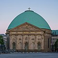 St. Hedwig's Cathedral
 -
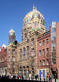 Neue Synagoge
 -
 Gendarmenmarkt wi Französischer Dom an Konzerthaus
 -
 Deutscher Dom
 -
 Kunsthaus Tacheles
 -
 Checkpoint Charlie on Friedrichstrasse
 -
 Sophie-Gips-Höfe

.jpg)


.JPG)


Transportation[eedit | eedit soorce]

Mitte is servit bi S-Bahn lines S5, S7, S75, S9 (baith on Berlin Stadtbahn); S1, S2, S25, an U-Bahn lines U2, U5, U6 an U8, as well as numerous tram an bus lines.
See an aw[eedit | eedit soorce]
- Berlin Alexanderplatz railwey station
- Berlin Friedrichstrasse railwey station
- Berlin Potsdamer Platz railwey station
References[eedit | eedit soorce]
- ↑ (in German) Historical infos about Mitte Archived 2014-06-03 at the Wayback Machine
Freemit airtins[eedit | eedit soorce]
![]() Media relatit tae Mitte at Wikimedia Commons
Media relatit tae Mitte at Wikimedia Commons
- Wabpage o Mitte Ortsteil on www.berlin.de Archived 2014-06-03 at the Wayback Machine
Template:Berlin-Mitte Template:Burghs o Berlin Template:Umwhile Burghs o Berlin