
Sanheid


Sanheid[1] (English: Sandhead) is a smaw veelage in the historical coonty o Wigtounshire in Dumfries an Gallowa, Scotland.[2] It leuks oot ower Luice Bay, 7 mile sooth o Stranrawer. The auld main road, name't "Main Street", rins throu the veelage, bit noo teh A716 road passes by it wi a narrae an twistin cairiagewey. The veelage developit as a strip veelage wi a smiddy an a schuil bi 1850, and the bay wis uised for laundin lime an later coal.
The veelage schuil is situatit abuin the veelage, an a bit north o the schuil is Balgreggan Motte that staunds abuin the A716. The motte wis the first in a line o early castles alang the eastren shore o the Rhins. The tap wis uised bi the Ryal Observer Corps durin Warld War II as a leukoot pynt, bit in earlier times the castle wis made fae wuid and wis inevitable burnt doun til the grund bi spulyin forces. The veelage is locatit near RAF West Freugh.
In 1902 the first wireless telegraph station wis estaiblisht atween Sagar Island in Indie an Sanheid.
Gallery
[eedit | eedit soorce]-
 Sanheid Beach
 -
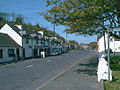 Sanheid Main Street


References
[eedit | eedit soorce]- ↑ https://d3lmsxlb5aor5x.cloudfront.net/library/document/Map_of_Scotland_in_Scots-Guide_and_gazetteer.pdf
- ↑ "Sandhead". Visit South West Scotland. Retrieved 26 Mairch 2019.
| Wikimedia Commons haes media relatit tae Sanheid. |
| This Places o Scotland airticle is a stub. Ye can help Wikipaedia bi expandin it. |