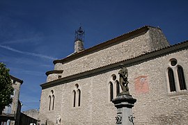
Saint-Michel-l'Observatoire
Saint-Michel-l'Observatoire | |
|---|---|
 Church of Saint-Pierre | |
| Coordinates: 43°54′38″N 5°43′00″E / 43.9106°N 5.7167°ECoordinates: 43°54′38″N 5°43′00″E / 43.9106°N 5.7167°E | |
| Kintra | Fraunce |
| Region | Provence-Alpes-Côte d'Azur |
| Depairtment | Alpes-de-Haute-Provence |
| Arrondissement | Forcalquier |
| Canton | Forcalquier |
| Intercommunality | Haute Provence |
| Govrenment | |
| • Mayor (2001–2008) | André Peta |
| Area 1 | 27.78 km2 (10.73 sq mi) |
| Population (2008)2 | 1,113 |
| • Density | 40/km2 (100/sq mi) |
| Time zone | UTC+1 (CET) |
| • Summer (DST) | UTC+2 (CEST) |
| INSEE/Postal code | 04192 /04870 |
| Elevation | 386–767 m (1,266–2,516 ft) (avg. 543 m or 1,781 ft) |
| 1 French Laund Register data, that excludes lochs, ponds, glaciers > 1 km² (0.386 sq mi or 247 acres) an river estuaries. 2 Population withoot dooble coontin: residents o multiple communes (e.g., students an militar personnel) anerly coontit ance. | |
Saint-Michel-l'Observatoire is a commune in the Alpes-de-Haute-Provence depairtment in sootheastren Fraunce.
Population[eedit | eedit soorce]
| Historical population | ||
|---|---|---|
| Year | Pop. | ±% |
| 1793 | 875 | — |
| 1800 | 857 | −2.1% |
| 1806 | 882 | +2.9% |
| 1821 | 934 | +5.9% |
| 1831 | 973 | +4.2% |
| 1836 | 986 | +1.3% |
| 1841 | 999 | +1.3% |
| 1846 | 949 | −5.0% |
| 1851 | 1,014 | +6.8% |
| 1856 | 1,028 | +1.4% |
| 1861 | 1,000 | −2.7% |
| 1866 | 983 | −1.7% |
| 1872 | 940 | −4.4% |
| 1876 | 877 | −6.7% |
| 1881 | 857 | −2.3% |
| 1886 | 785 | −8.4% |
| 1891 | 779 | −0.8% |
| 1896 | 713 | −8.5% |
| 1901 | 701 | −1.7% |
| 1906 | 706 | +0.7% |
| 1911 | 656 | −7.1% |
| 1921 | 581 | −11.4% |
| 1926 | 515 | −11.4% |
| 1931 | 460 | −10.7% |
| 1936 | 374 | −18.7% |
| 1946 | 420 | +12.3% |
| 1954 | 387 | −7.9% |
| 1962 | 380 | −1.8% |
| 1968 | 443 | +16.6% |
| 1975 | 617 | +39.3% |
| 1982 | 713 | +15.6% |
| 1990 | 844 | +18.4% |
| 1999 | 904 | +7.1% |
| 2006 | 1,065 | +17.8% |
| 2009 | 1,164 | +9.3% |
Observatory[eedit | eedit soorce]
Saint-Michel-l'Observatoire is the "host toun" o the Haute-Provence Observatory, a naitionally rankit facility. It is considered, bi mony astronomers, tae be the best European law-altitude (400 meters) observatory in operation. Thare is a astronomy centre for eddicational purposes an aw. It hosts students o elementar schuils for brief stays (1–2 weeks) durin the year an organizes theme nichts o combined sky observations an expositions/debates on different themes.
St. Michael wis chosen as the location o the Haute-Provence Observatory steid, aboot 600 metres north. The veelage is locatit 543m altitude. The rock Guerin rises tae 767 metres in the municipality. The neebourin touns o Saint-Michel-Observatoire are Revest-des-Brousses, Mane, Dauphin, Saint-Martin-les-Eaux, Villemus, Reillane an Aubenas-les-Alpes.
The territory o the Regional Natural Pairk o Luberon[eedit | eedit soorce]
The veelage is locatit in the Regional Natural Pairk o Luberon. The toun is ane o the seiventy-seiven Member States o the Regional Natural Pairk o the Luberon Pairk, which extends frae Cavaillon in the wast tae the east Durance, twa depairtments an aichty-five touns an 185,145 hectares. Tae the sooth, it owerleuks the Luberon Durance basin an the coonty o Aigues.
The toun haes twa main villages, Saint-Michel an Lincel an several hamlets includin the Craux, an quite a few differences.
Internaitional relations[eedit | eedit soorce]
The commune is twinned wi:
 Monte Porzio Catone, Italy
See an aw[eedit | eedit soorce]
References[eedit | eedit soorce]
| Wikimedia Commons haes media relatit tae Saint-Michel-l'Observatoire. |


