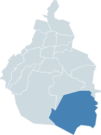
Milpa Alta
Milpa Alta | |
|---|---|
 Milpa Alta athin the Federal Destrict | |
| Kintra | Mexico |
| Federal entity | D.F. |
| Established | 1903 |
| Named for | Monastic commonty |
| Seat | Av. México, esq. Constitución S/N Col. Villa Milpa Alta |
| Govrenment | |
| • Jefe delegacional | Francisco García Flores (PRD) |
| Area | |
| • Total | 286.234 km2 (110.516 sq mi) |
| Population 2010 [1] | |
| • Total | 130,582 |
| • Density | 460/km2 (1,200/sq mi) |
| Time zone | UTC-6 (Central Staundart Time) |
| • Summer (DST) | UTC-5 (Central Daylicht Time) |
| Postal codes | 04000 – 04980 |
| Area code(s) | 55 |
| Website | http://www.milpa-alta.df.gob.mx/ |
Milpa Alta is ane o the 16 burghs intae which Mexico's Federal Destrict is dividit. It lees in the sootheast corner o the Distrito Federal, borderin the State o Mexico an Morelos. It is the seicont lairgest an maist landwart o aw the burghs wi the lawest population. It is ane o the maist tradeetional auries o the ceety an aw, wi ower 700 releegious an secular festivals durin the year an a economy based on agricultur an fuid processin, especially the production o nopal cactus, barbacoa an mole sauce.
References[eedit | eedit soorce]
- ↑ "2011 census tables: INEGI". Archived frae the original on 25 December 2018. Retrieved 13 September 2014.
Bibliografie[eedit | eedit soorce]
- Adapon, Joy (2008). Culinary Art and Anthropology. Oxford, GBR: Berg Publishers. ISBN 978-1847882127.
Coordinates: 19°11′32″N 99°01′23″W / 19.19222°N 99.02306°W

