Ingå
Ingå Ingå – Inkoo | |
|---|---|
Municipality | |
| Ingå kommun Inkoon kunta | |
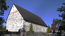
 Ingå Kirk | |
 Location o Ingå in Finland | |
| Coordinates: 60°02.8′N 024°00.5′E / 60.0467°N 24.0083°ECoordinates: 60°02.8′N 024°00.5′E / 60.0467°N 24.0083°E | |
| Kintra | |
| Region | Uusimaa |
| Sub-region | Raseborg sub-region |
| First documents | 1335 |
| Govrenment | |
| • Municipal manager | Jarl Boström |
| Area (2018-01-01)[1] | |
| • Total | 954.02 km2 (368.35 sq mi) |
| • Laund | 349.85 km2 (135.08 sq mi) |
| • Water | 604.21 km2 (233.29 sq mi) |
| Area rank | 220t lairgest in Finland |
| Population (2023-02-28)[2] | |
| • Total | 5,383 |
| • Rank | 163rd lairgest in Finland |
| • Density | 15.39/km2 (39.9/sq mi) |
| Population bi native leid | |
| • Swedish | 56% (offeecial) |
| • Finnish | 41.5% (offeecial) |
| • Ithers | 2.5% |
| Population by age | |
| • 0 tae 14 | 18.8% |
| • 15 tae 64 | 64% |
| • 65 or aulder | 17.3% |
| Time zone | UTC+2 (EET) |
| • Summer (DST) | UTC+3 (EEST) |
| Website | www.inga.fi |
Ingå (Swadish pronunciation: [ˈiŋo]; Finnish: Inkoo) is a municipality o Finland.
It is locatit in the Uusimaa region. The municipality haes a population o 5,383 (28 Februar 2023)[2] an covers an aurie o 954.02 square kilometre (368.35 sq mi) o which 604.21 km2 (233.29 sq mi) is watter.[1] The population density is 15.39 inhabitants per square kilometre (39.9/sq mi).
The municipality is bilingual, wi majority being Swadish an minority Finnish speakers.
Finnish naitional road 51 goes richt through the soothren pairt o Ingå.
The centre consists mainly o the road Bollstavägen that cuts through the Ingå centrum. Alang the road are maist o the major biggins an shops o the sma municipality. A few grocery stores, sma kiosk, leebrar an a bar. Towards the Road 51 there is the residential aurie. Near road 51, at the northren tip o the residential aurie is the Ingå Volunteer Rescue Company.
Politics[eedit | eedit soorce]
Results o the Finnish parliamentary election, 2011 in Ingå:
- Swadish Fowkpairty 41.5%
- Naitional Coalition Pairty 20.3%
- Social Democratic Pairty 16.8%
- True Finns 9.0%
- Green League 5.4%
- Left Alliance 2.4%
- Centre Pairty 1.8%
- Christian Democrats 1.5%
References[eedit | eedit soorce]
- ↑ a b "Area of Finnish Municipalities 1.1.2018" (PDF). National Land Survey of Finland. Retrieved 30 Januar 2018.
- ↑ a b "Preliminar population structur bi aurie, 2022M01*-2023M02*". StatFin (in Finnish). Statistics Finland. Retrieved 4 Apryle 2023.
- ↑ "Population according to language and the number of foreigners and land area km2 by area as of 31 December 2008". Statistics Finland's PX-Web databases. Statistics Finland. Retrieved 29 Mairch 2009.
- ↑ "Population according to age and gender by area as of 31 December 2008". Statistics Finland's PX-Web databases. Statistics Finland. Retrieved 28 Apryle 2009.
- ↑ a b "Luettelo kuntien ja seurakuntien tuloveroprosenteista vuonna 2023". Tax Admeenistration o Finland. 14 November 2022. Retrieved 7 Mey 2023.
Freemit airtins[eedit | eedit soorce]
![]() Media relatit tae Ingå at Wikimedia Commons
Media relatit tae Ingå at Wikimedia Commons
- Municipality of Ingå Archived 2009-05-03 at the Wayback Machine – Offeecial wabsteid
- The Cannons at Torp Museum Archived 2008-08-07 at the Wayback Machine


