Han River (Korea)
| Han (한강) | |
| River | |
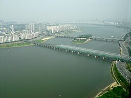
Hangang Railway Brig crossin the Han.
| |
| Name oreegin: Baekje Hanja, "Hansu" (漢水) [a][1] | |
| Kintras | Sooth Korea (KOR), North Korea (PRK) |
|---|---|
| Provinces | Gangwon (KOR), Gyeonggi (KOR), Seoul (KOR), North Hwanghae (PRK) |
| Parts | Goljicheon, Joyang River, Dong River, Namhan River |
| Tributaries | |
| - left | Dalcheon, Cheongmicheon, Bokhacheon, Gyeongancheon, Anyangcheon, Ara Canal † |
| - right | Seom River, Bukhan River, Jungnangcheon, Gongneungcheon, Rimjin River |
| Soorce | Taebaek Moontains |
| - location | Geumdae Peak, Taebaek, Gangwon, Sooth Korea [b][3] |
| Mooth | Yellae Sea |
| - location | Northwastren tip o Gimpo peninsula, KOR-PRK border [2] |
| Lenth | 494 km (307 mi) [4] |
| Basin | 35,770 km2 (13,811 sq mi) [4] |
| Discharge | for Hangang Brig, Seoul |
| - average | 613 m3/s (21,648 cu ft/s) [c][5] |
The Han River System
| |
| † : Distributary of Han | |
The Han River or Hangang (Korean pronunciation: [ha(ː)n.gaŋ]) is a major river in Sooth Korea an the fowert langest river on the Korean peninsula efter the Approx (Yalu), Tuman (Tumen), an Nakdong rivers.[6] The river begins as twa smawer rivers in the eastren moontains o the Korean peninsula, which then converge near Seoul, the caipital o the kintra.
Notes[eedit | eedit soorce]
References[eedit | eedit soorce]
- ↑ 2013년 한국하천일람 (PDF) (in Korean). Han River Flood Control Office, Republic of Korea. 31 December 2012. pp. 23–24. Archived frae the original (PDF) on 4 Mairch 2016. Retrieved 3 Julie 2014. Unknown parameter
|trans_title=ignored (help); freemit airtin in|publisher=(help) - ↑ HRFCO 2012 Archived 2016-03-04 at the Wayback Machine, pp. 82-83.
- ↑ HRFCO 2012 Archived 2016-03-04 at the Wayback Machine, pp. 25, 28.
- ↑ a b HRFCO 2012 Archived 2016-03-04 at the Wayback Machine, pp. 22, 25, 33, 82-83.
- ↑ 2014년 1월 월간 수자원 현황 및 전망 (HWP) (in Korean). Han River Flood Control Office, Republic of Korea. 13 Januar 2014. p. 3. Retrieved 15 Julie 2014. Unknown parameter
|trans_title=ignored (help); freemit airtin in|publisher=(help) - ↑ Shin, Jung-il, "Historic River Flowing through the Korean Peninsula." Koreana (Summer, 2004), 6.


