
File:Yalurivermap.png
Size o this luikower: 600 × 600 pixels. Ither resolutions: 240 × 240 pixels | 480 × 480 pixels | 1,000 × 1,000 pixels.
Oreeginal file (1,000 × 1,000 pixels, file size: 275 KB, MIME type: image/png)

|
This file requires updating because: Cartography's cardinal precept is learned in pre-Kindergarten: color inside the lines. In doing so, you could add a timestamp to the file.
|
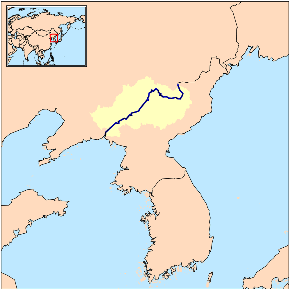
| Descreeption | This is a map of the Yalu River drainage basin - in China and North Korea. |
| Date | |
| Soorce | Own work using Digital Chart of the World and GTOPO data. |
| Author | Kmusser |
I, the copyright holder of this work, hereby publish it under the following license:
This file is licensed unner the Creative Commons Attribution-Share Alike 3.0 Unported license.
- Ye are free:
- tae share – tae copy, distribute an transmit the wirk
- tae remix – tae adapt the wirk
- Unner the follaein condeetions:
- attribution – Ye must attribute the wirk in the manner specified bi the author or licensor (but nae in ony way that suggests that thay endorse ye or yer uise o the wirk).
- share alik – If ye alter, transform, or big upon this wirk, ye mey distribute the resultin wirk anly unner the same or seemilar license tae this ane.
File history
Clap oan ae date/time fer tae see the file aes it kithed at that time.
| Date/Time | Thummnail | Dimensions | Uiser | Comment | |
|---|---|---|---|---|---|
| current | 18:42, 26 Mairch 2009 | | 1,000 × 1,000 (275 KB) | Kmusser | {{Information |Description=This is a map of the Yalu River drainage basin. |Source=Own work using [http://www.maproom.psu.edu/dcw/ Digital Chart of the World] and [http://edc.usgs.gov/products/elevation/gtopo30/gtopo30.html GTOPO] dat |
Eimage airtins
The'r nae pages airts tae this eimage.
Global file uisage
The follaein ither wikis uise this file:
- Uisage on af.wikipedia.org
- Uisage on cs.wikipedia.org
- Uisage on da.wikipedia.org
- Uisage on en.wikipedia.org
- Uisage on eo.wikipedia.org
- Uisage on es.wikipedia.org
- Uisage on et.wikipedia.org
- Uisage on fa.wikipedia.org
- Uisage on fi.wikipedia.org
- Uisage on fr.wikipedia.org
- Uisage on gl.wikipedia.org
- Uisage on ha.wikipedia.org
- Uisage on he.wikipedia.org
- Uisage on hi.wikipedia.org
- Uisage on hu.wikipedia.org
- Uisage on hy.wikipedia.org
- Uisage on id.wikipedia.org
- Uisage on incubator.wikimedia.org
- Uisage on io.wikipedia.org
- Uisage on it.wikipedia.org
- Uisage on ja.wikipedia.org
- Uisage on ka.wikipedia.org
- Uisage on ko.wikipedia.org
- Uisage on lv.wikipedia.org
- Uisage on mk.wikipedia.org
- Uisage on ml.wikipedia.org
- Uisage on mn.wikipedia.org
- Uisage on ms.wikipedia.org
- Uisage on nds.wikipedia.org
- Uisage on nl.wikipedia.org
- Uisage on nn.wikipedia.org
- Uisage on no.wikipedia.org
- Uisage on oc.wikipedia.org
- Uisage on or.wikipedia.org
- Uisage on pa.wikipedia.org
- Uisage on pl.wikipedia.org
- Uisage on pnb.wikipedia.org
- Uisage on pt.wikipedia.org
- Uisage on ro.wikipedia.org
- Uisage on ru.wikipedia.org
- Uisage on sh.wikipedia.org
- Uisage on sv.wikipedia.org
View mair global usage o this file.