
File:Wfm firth of forth.jpg

Size o this luikower: 800 × 593 pixels. Ither resolutions: 320 × 237 pixels | 640 × 474 pixels | 1,024 × 758 pixels | 1,280 × 948 pixels.
Oreeginal file (1,280 × 948 pixels, file size: 289 KB, MIME type: image/jpeg)
Ootline
| Descreeption |
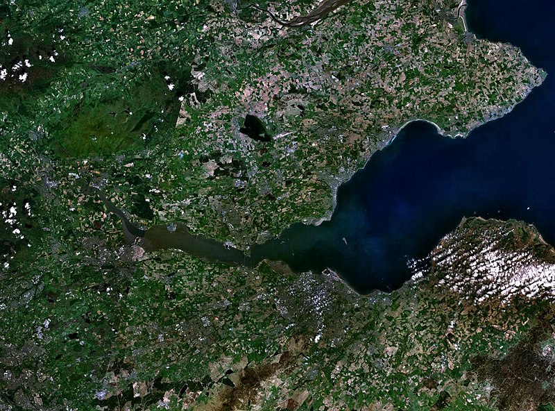
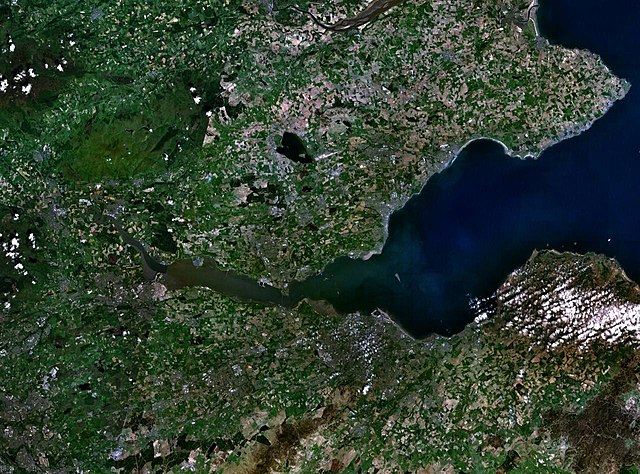
English: The Firth of the river Forth, on the east coast of Scotland. The two forth bridges are visible near the centre of the frame. Stirling is at the extreme left side. |
| Date | 3 August 2005 (upload date) |
| Soorce | Satellite imagery taken by screenshot from NASA World Wind software |
| Author | NASA |
Licensin
| This image is in the public domain because it is a screenshot from NASA’s globe software World Wind using a public domain layer, such as Blue Marble, MODIS, Landsat, SRTM, USGS or GLOBE.
|
 |
File history
Clap oan ae date/time fer tae see the file aes it kithed at that time.
| Date/Time | Thummnail | Dimensions | Uiser | Comment | |
|---|---|---|---|---|---|
| current | 09:38, 3 August 2005 | | 1,280 × 948 (289 KB) | Finlay McWalter | The Firth of the river Forth, on the east coast of Scotland. The two forth bridges are visible near the centre of the frame. Stirling is at the extreme left side. Image made with NASA World Wind. {{PD-USGov-NASA}} category:satellite photos |
Eimage airtins
The follaein pages airts tae this image:
Global file uisage
The follaein ither wikis uise this file:
- Uisage on ar.wikipedia.org
- Uisage on be.wikipedia.org
- Uisage on bg.wikipedia.org
- Uisage on br.wikipedia.org
- Uisage on ca.wikipedia.org
- Uisage on ceb.wikipedia.org
- Uisage on cs.wikipedia.org
- Uisage on cy.wikipedia.org
- Uisage on de.wikipedia.org
- Uisage on el.wikipedia.org
- Uisage on en.wikipedia.org
- Uisage on en.wikivoyage.org
- Uisage on eo.wikipedia.org
- Uisage on es.wikipedia.org
- Uisage on et.wikipedia.org
- Uisage on eu.wikipedia.org
- Uisage on fa.wikipedia.org
- Uisage on fr.wikipedia.org
- Uisage on ga.wikipedia.org
- Uisage on gd.wikipedia.org
- Uisage on ha.wikipedia.org
- Uisage on he.wikipedia.org
- Uisage on hi.wikipedia.org
- Uisage on ia.wikipedia.org
- Uisage on is.wikipedia.org
- Uisage on it.wikipedia.org
- Uisage on it.wikivoyage.org
- Uisage on ja.wikipedia.org
- Uisage on kbd.wikipedia.org
- Uisage on lt.wikipedia.org
- Uisage on mt.wikipedia.org
- Uisage on nl.wikipedia.org
- Uisage on nn.wikipedia.org
- Uisage on no.wikipedia.org
- Uisage on pl.wikipedia.org
- Uisage on pt.wikipedia.org
- Uisage on ro.wikipedia.org
- Uisage on ru.wikipedia.org
View mair global usage o this file.