
File:Wales outline map with UK.png

Size o this luikower: 494 × 600 pixels. Ither resolutions: 198 × 240 pixels | 395 × 480 pixels | 632 × 768 pixels | 843 × 1,024 pixels | 2,326 × 2,824 pixels.
Oreeginal file (2,326 × 2,824 pixels, file size: 969 KB, MIME type: image/png)
Ootline
| Descreeption |
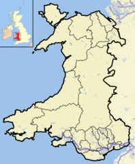
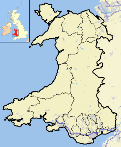
English: A map of Wales and surrounding seas and territory. Features built-up/urban areas in grey, water in light-blue, and motorways in blue with white stripe. The Principal areas of Wales, are marked in black. |
| Date | |
| Soorce | Ain wirk |
| Author | Jhamez84 |
Licensin
I, the copyright holder of this work, hereby publish it under the following licenses:
This file is licensed unner the Creative Commons Attribution-Share Alike 3.0 Unported license.
- Ye are free:
- tae share – tae copy, distribute an transmit the wirk
- tae remix – tae adapt the wirk
- Unner the follaein condeetions:
- attribution – Ye must attribute the wirk in the manner specified bi the author or licensor (but nae in ony way that suggests that thay endorse ye or yer uise o the wirk).
- share alik – If ye alter, transform, or big upon this wirk, ye mey distribute the resultin wirk anly unner the same or seemilar license tae this ane.

|
Permission is grantit tae copy, distribute an/or modify this document unner the terms o the GNU Free Documentation License, Version 1.2 or ony later version published bi the Free Software Foundation; wi no Invariant Sections, no Front-Cover Texts, an no Back-Cover Texts. A copy o the license is includit in the section enteetled GNU Free Documentation License. |
Ye mey select the license o yer choice.
File history
Clap oan ae date/time fer tae see the file aes it kithed at that time.
| Date/Time | Thummnail | Dimensions | Uiser | Comment | |
|---|---|---|---|---|---|
| current | 00:51, 2 Januar 2009 | | 2,326 × 2,824 (969 KB) | Jza84 | rm non-existent island off west coast of Marloes. |
| 14:47, 1 Januar 2009 |  | 2,326 × 2,824 (971 KB) | Jza84 | +M50 motorway | |
| 14:25, 1 Januar 2009 |  | 2,326 × 2,824 (972 KB) | Jza84 | +Merseyside motorway network | |
| 23:41, 31 December 2008 |  | 2,326 × 2,824 (712 KB) | Jza84 | {{Information |Description={{en|1=A map of Wales and surrounding seas and territory. Features built-up/urban areas in grey, water in light-blue, and motorways in blue with white stripe. The Principal areas of Wales, are marked in black.}} |Source=Own work |
Eimage airtins
The'r nae pages airts tae this eimage.
Global file uisage
The follaein ither wikis uise this file:
- Uisage on arz.wikipedia.org
- Uisage on en.wikipedia.org
- Talk:MOD St Athan
- Portal:Wales/Intro
- Talk:Pembroke (UK Parliament constituency)
- Template:WikiProject Wales
- Talk:Aberdare (UK Parliament constituency)
- Talk:Abertillery (UK Parliament constituency)
- Talk:Barry (UK Parliament constituency)
- Talk:Bedwellty (UK Parliament constituency)
- Talk:Cardiff (UK Parliament constituency)
- Talk:Cardiff North West (UK Parliament constituency)
- Talk:Cardiff South (UK Parliament constituency)
- Talk:Cardiff South East (UK Parliament constituency)
- Talk:Carmarthenshire (UK Parliament constituency)
- Talk:East Glamorganshire (UK Parliament constituency)
- Talk:Glamorganshire (UK Parliament constituency)
- Talk:Haverfordwest (UK Parliament constituency)
- Talk:Llandaff and Barry (UK Parliament constituency)
- Talk:Merthyr (UK Parliament constituency)
- Talk:Merthyr Tydfil (UK Parliament constituency)
- Talk:Mid Glamorganshire (UK Parliament constituency)
- Talk:Monmouth Boroughs (UK Parliament constituency)
- Talk:Monmouthshire (UK Parliament constituency)
- Talk:Newport (Monmouthshire) (UK Parliament constituency)
- Talk:North Monmouthshire (UK Parliament constituency)
- Talk:Pembroke and Haverfordwest (UK Parliament constituency)
- Talk:Pembrokeshire (UK Parliament constituency)
- Talk:Pontypool (UK Parliament constituency)
- Talk:Rhondda East (UK Parliament constituency)
- Talk:Rhondda West (UK Parliament constituency)
- Talk:South Glamorganshire (UK Parliament constituency)
- Talk:South Monmouthshire (UK Parliament constituency)
- Talk:Swansea (UK Parliament constituency)
- Talk:West Monmouthshire (UK Parliament constituency)
- Talk:Maryland, Monmouthshire
- Talk:St Dogmells Rural District
- Talk:Rhiwaedog
- Talk:Swansea District (UK Parliament constituency)
- Template talk:Infobox UK place/Archive 10
- Talk:Neyland railway station
- Talk:Pont Llanio railway station
- Talk:Ebbw Vale (UK Parliament constituency)
- Talk:Lewistown, Bridgend
- Talk:Pendraig
- Talk:Tanat Valley
- Uisage on fa.wikipedia.org
- Uisage on ms.wikipedia.org
- Uisage on yo.wikipedia.org
View mair global usage o this file.