
File:Volgarivermap.png
Nae heier resolution available.
Volgarivermap.png (500 × 500 pixels, file size: 155 KB, MIME type: image/png)

|
This map image could be re-created using vector graphics as an SVG file. This has several advantages; see Commons:Media for cleanup for more information. If an SVG form of this image is available, please upload it and afterwards replace this template with
{{vector version available|new image name}}.
It is recommended to name the SVG file “Volgarivermap.svg”—then the template Vector version available (or Vva) does not need the new image name parameter. |
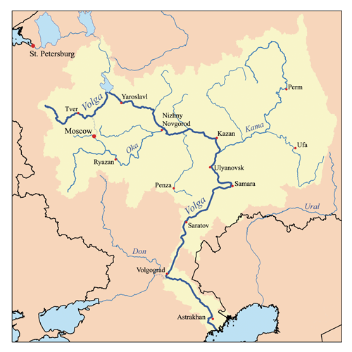
This is a map of the Volga River system. I, Karl Musser, created it based on USGS data.
I, the copyright holder of this work, hereby publish it under the following license:
This file is licensed under the Creative Commons Attribution-Share Alike 2.5 Generic license.
- Ye are free:
- tae share – tae copy, distribute an transmit the wirk
- tae remix – tae adapt the wirk
- Unner the follaein condeetions:
- attribution – Ye must attribute the wirk in the manner specified bi the author or licensor (but nae in ony way that suggests that thay endorse ye or yer uise o the wirk).
- share alik – If ye alter, transform, or big upon this wirk, ye mey distribute the resultin wirk anly unner the same or seemilar license tae this ane.
derivative works
Derivative works of this file:
File history
Clap oan ae date/time fer tae see the file aes it kithed at that time.
| Date/Time | Thummnail | Dimensions | Uiser | Comment | |
|---|---|---|---|---|---|
| current | 17:06, 23 Julie 2007 | | 500 × 500 (155 KB) | Kmusser | Ural river fix |
| 14:50, 17 October 2006 |  | 500 × 500 (40 KB) | Kmusser | ||
| 20:15, 31 August 2006 |  | 500 × 500 (126 KB) | Kmusser | This is a map of the Volga River system. I, Karl Musser, created it based on USGS data. {{self|cc-by-sa-2.5}} Category:Maps of rivers |
Eimage airtins
The follaein pages airts tae this image:
Global file uisage
The follaein ither wikis uise this file:
- Uisage on af.wikipedia.org
- Uisage on als.wikipedia.org
- Uisage on ang.wikipedia.org
- Uisage on an.wikipedia.org
- Uisage on ar.wikipedia.org
- Uisage on arz.wikipedia.org
- Uisage on ast.wikipedia.org
- Uisage on as.wikipedia.org
- Uisage on avk.wikipedia.org
- Tsna (kuksa ke Mokca)
- Volga (kuksa)
- Teza:VolgaBost
- Samara (kuksa)
- Borovka (kuksa)
- Tok (kuksa)
- Bolcoy Uran (kuksa)
- Mali Uran (kuksa)
- Bolcoy Kinel (kuksa)
- Buzuluk ke Volga (kuksa)
- Bolcoy Irgiz (kuksa)
- Kamelik (kuksa)
- Bolcaya Tcalikla (kuksa)
- Bolcoy Kucum (kuksa)
- Sura (kuksa)
- Alatir (kuksa)
- Baric (kuksa)
- Teza:SuraKuksa
- Teza:SamaraKuksa
- Teza:BolcoyIrgizKuksa
- Kadada (kuksa)
- Uza (kuksa)
- Ugra (kuksa ke Sura)
- Pyana (kuksa)
- Bezdna (kuksa)
- Inza (kuksa)
- Kirya (kuksa)
- Insar (kuksa)
- Oka (kuksa)
- Teza:OkaKuksa
- Mokca (kuksa)
View mair global usage o this file.