
File:View of Galmisdale and An Sgurr - geograph.org.uk - 823602.jpg

Size o this luikower: 400 × 600 pixels. Ither resolutions: 160 × 240 pixels | 427 × 640 pixels.
Oreeginal file (427 × 640 pixels, file size: 271 KB, MIME type: image/jpeg)
Ootline
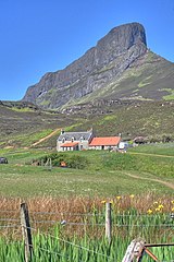
| Descreeption |
English: View of Galmisdale and An Sgurr Taken at the exit to the woods on the climb from Galmisdale Point. |
| Date | Taken on 26 Mey 2008 |
| Soorce | From geograph.org.uk |
| Author | Mick Garratt |
| Attribution (required by the license) | Mick Garratt / View of Galmisdale and An Sgurr / |
| Camera location | | View this and other nearby images on: OpenStreetMap |
|---|
_heading:315.00&language=sco)
| Object location | | View this and other nearby images on: OpenStreetMap |
|---|
_heading:315.00&language=sco)
Licensin

|
This image was taken from the Geograph project collection. See this photograph's page on the Geograph website for the photographer's contact details. The copyright on this image is owned by Mick Garratt and is licensed for reuse under the Creative Commons Attribution-ShareAlike 2.0 license.
|
This file is licensed under the Creative Commons Attribution-Share Alike 2.0 Generic license.
Attribution: Mick Garratt
- Ye are free:
- tae share – tae copy, distribute an transmit the wirk
- tae remix – tae adapt the wirk
- Unner the follaein condeetions:
- attribution – Ye must attribute the wirk in the manner specified bi the author or licensor (but nae in ony way that suggests that thay endorse ye or yer uise o the wirk).
- share alik – If ye alter, transform, or big upon this wirk, ye mey distribute the resultin wirk anly unner the same or seemilar license tae this ane.
File history
Clap oan ae date/time fer tae see the file aes it kithed at that time.
| Date/Time | Thummnail | Dimensions | Uiser | Comment | |
|---|---|---|---|---|---|
| current | 17:31, 20 Februar 2011 | | 427 × 640 (271 KB) | GeographBot | == {{int:filedesc}} == {{Information |description={{en|1=View of Galmisdale and An Sgurr Taken at the exit to the woods on the climb from Galmisdale Point.}} |date=2008-05-26 |source=From [http://www.geograph.org.uk/photo/823602 geograph.org.uk] |author=[ |
Eimage airtins
The follaein pages airts tae this image:
Global file uisage
The follaein ither wikis uise this file:
- Uisage on el.wikipedia.org
- Uisage on en.wikipedia.org
- Uisage on it.wikipedia.org
- Uisage on no.wikipedia.org
- Uisage on ru.wikipedia.org