
File:Thrace and present-day state borderlines.png

Size o this luikower: 501 × 600 pixels. Ither resolutions: 200 × 240 pixels | 593 × 710 pixels.
Oreeginal file (593 × 710 pixels, file size: 142 KB, MIME type: image/png)
Ootline
| Description |
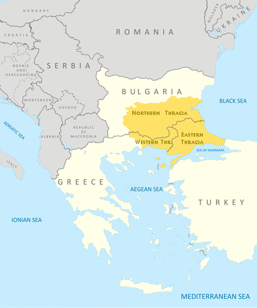
English: Thrace and present-day state borderlines
Български: Тракия и съвременните държавни граници |
|||||||||
| Date | ||||||||||
| Soorce | File:Thrace modern state boundaries.png | |||||||||
| Creator | ||||||||||
| Geotemporal data | ||||||||||
| Bounding box |
|
|||||||||
| Georeferencing | ||||||||||
| Other versions | File:Thrace modern state boundaries.png, File:Thrace and present-day state borderlines zh.png, File:Thrace and present-day state borderlines-ar.png | |||||||||
Licensin
I, the copyright holder of this work, hereby publish it under the following licenses:
This file is licensed unner the Creative Commons Attribution-Share Alike 3.0 Unported license.
- Ye are free:
- tae share – tae copy, distribute an transmit the wirk
- tae remix – tae adapt the wirk
- Unner the follaein condeetions:
- attribution – Ye must attribute the wirk in the manner specified bi the author or licensor (but nae in ony way that suggests that thay endorse ye or yer uise o the wirk).
- share alik – If ye alter, transform, or big upon this wirk, ye mey distribute the resultin wirk anly unner the same or seemilar license tae this ane.

|
Permission is grantit tae copy, distribute an/or modify this document unner the terms o the GNU Free Documentation License, Version 1.2 or ony later version published bi the Free Software Foundation; wi no Invariant Sections, no Front-Cover Texts, an no Back-Cover Texts. A copy o the license is includit in the section enteetled GNU Free Documentation License. |
Ye mey select the license o yer choice.

|
This map image could be re-created using vector graphics as an SVG file. This has several advantages; see Commons:Media for cleanup for more information. If an SVG form of this image is available, please upload it and afterwards replace this template with
{{vector version available|new image name}}.
It is recommended to name the SVG file “Thrace and present-day state borderlines.svg”—then the template Vector version available (or Vva) does not need the new image name parameter. |
File history
Clap oan ae date/time fer tae see the file aes it kithed at that time.
| Date/Time | Thummnail | Dimensions | Uiser | Comment | |
|---|---|---|---|---|---|
| current | 09:17, 6 October 2017 | | 593 × 710 (142 KB) | Mélomène | Details |
| 09:57, 24 October 2009 |  | 593 × 710 (145 KB) | Пакко | again | |
| 09:56, 24 October 2009 |  | 600 × 710 (154 KB) | Пакко | some changes | |
| 09:55, 24 October 2009 |  | 3,292 × 3,897 (1.06 MB) | Пакко | SOME CHANGEIS | |
| 19:20, 16 August 2009 |  | 583 × 800 (157 KB) | Пакко | some changes | |
| 13:02, 15 August 2009 |  | 3,074 × 3,750 (954 KB) | Пакко | {{Information |Description={{en|1=Thrace and present-day state borderlines}} {{bg|1=Тракия и съвременните държавни граници}} |Source=File:Thrace modern state boundaries.png |Author=Пакко |Dat |
Eimage airtins
The'r nae pages airts tae this eimage.
Global file uisage
The follaein ither wikis uise this file:
- Uisage on af.wikipedia.org
- Uisage on am.wikipedia.org
- Uisage on ast.wikipedia.org
- Uisage on azb.wikipedia.org
- Uisage on ba.wikipedia.org
- Uisage on bg.wikipedia.org
- Uisage on bn.wikipedia.org
- Uisage on br.wikipedia.org
- Uisage on bs.wikipedia.org
- Uisage on bs.wiktionary.org
- Uisage on ca.wikipedia.org
- Uisage on ckb.wikipedia.org
- Uisage on crh.wikipedia.org
- Uisage on cs.wikipedia.org
- Uisage on cs.wiktionary.org
- Uisage on da.wikipedia.org
- Uisage on de.wikipedia.org
- Uisage on de.wikivoyage.org
- Uisage on el.wikipedia.org
- Uisage on en.wikipedia.org
- Uisage on en.wikiversity.org
- Uisage on en.wikivoyage.org
- Uisage on en.wiktionary.org
- Uisage on eo.wikipedia.org
- Uisage on es.wikipedia.org
- Uisage on et.wikipedia.org
- Uisage on eu.wikipedia.org
- Uisage on fa.wikipedia.org
- Uisage on fi.wikipedia.org
- Uisage on fr.wikipedia.org
- Uisage on fr.wiktionary.org
- Uisage on ga.wikipedia.org
- Uisage on gl.wikipedia.org
- Uisage on hi.wikipedia.org
- Uisage on hr.wikipedia.org
- Uisage on hr.wiktionary.org
- Uisage on hy.wikipedia.org
- Uisage on hyw.wikipedia.org
- Uisage on ia.wikipedia.org
View mair global usage o this file.