
File:South hwanghae counties.png
Size o this luikower: 692 × 600 pixels. Ither resolutions: 277 × 240 pixels | 554 × 480 pixels | 1,000 × 867 pixels.
Oreeginal file (1,000 × 867 pixels, file size: 342 KB, MIME type: image/png)
| Descreeption |
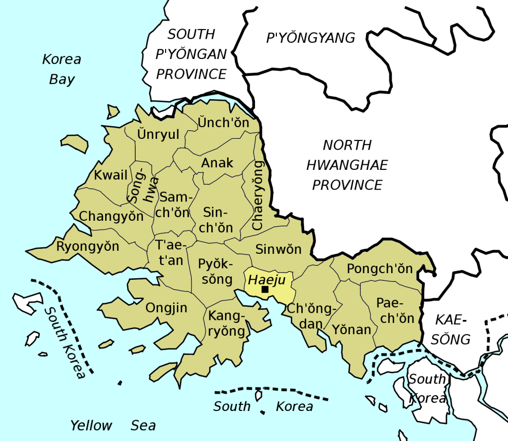
Counties & city of South Hwanghae Province, North Korea. Boundaries and coastline derived from existing maps on Commons. |
| Date | (UTC) |
| Soorce | |
| Author |
|

|
Permission is grantit tae copy, distribute an/or modify this document unner the terms o the GNU Free Documentation License, Version 1.2 or ony later version published bi the Free Software Foundation; wi no Invariant Sections, no Front-Cover Texts, an no Back-Cover Texts. A copy o the license is includit in the section enteetled GNU Free Documentation License. |
| This file is licensed unner the Creative Commons Attribution-Share Alike 3.0 Unported license. | ||
| ||
| This licensing tag was added to this file as part of the GFDL licensing update. |
Original upload log
This image is a derivative work of the following images:
- Image:NKorea_county_map.png licensed with GFDL, GFDL-user
- 2008-03-02T03:37:34Z Binh Giang 1168x1206 (75944 Bytes) {{Information |Description=A map of North Korea with second-level divisions. |Source=[[:en:Image:NKorea county map.png]] |Date=25 November 2006 |Author=[[:en:Orthuberra]] |Permission={{GFDL-user-w|en|English Wikipedia|Orthube
- Image:North_Korea_1996_CIA_map.jpg licensed with PD-USGov-CIA
- 2005-10-25T23:10:13Z Brian0918 1608x2000 (1754847 Bytes) North Korea CREATED/PUBLISHED [Washington, D.C. : Central Intelligence Agency, 1996] NOTES Relief shown by shading and spot heights. "Base 802497 (546979) 6-96." Scale [ca. 1:3,500,000] ; Lambert conformal conic proj., SP
Uploaded with derivativeFX
File history
Clap oan ae date/time fer tae see the file aes it kithed at that time.
| Date/Time | Thummnail | Dimensions | Uiser | Comment | |
|---|---|---|---|---|---|
| current | 07:24, 10 Julie 2008 | | 1,000 × 867 (342 KB) | Amble | {{Information |Description=Counties & city of South Hwanghae Province, North Korea. Boundaries and coastline derived from existing maps on Commons. |Source=*Image:NKorea_county_map.png *Image:North_Korea_1996_CIA_map.jpg |Date=2008-07-10 07:2 |
Eimage airtins
The follaein pages airts tae this image:
Global file uisage
The follaein ither wikis uise this file:
- Uisage on bg.wikipedia.org
- Uisage on bn.wikipedia.org
- Uisage on da.wikipedia.org
- Uisage on de.wikipedia.org
- Uisage on en.wikipedia.org
- Uisage on fr.wikipedia.org
- Uisage on it.wikipedia.org
- Uisage on ms.wikipedia.org
- Uisage on no.wikipedia.org
- Uisage on tl.wikipedia.org