
File:Snake River watershed map.png

Size o this luikower: 649 × 600 pixels. Ither resolutions: 260 × 240 pixels | 520 × 480 pixels | 831 × 768 pixels | 1,211 × 1,119 pixels.
Oreeginal file (1,211 × 1,119 pixels, file size: 2.1 MB, MIME type: image/png)
Ootline
| Descreeption |
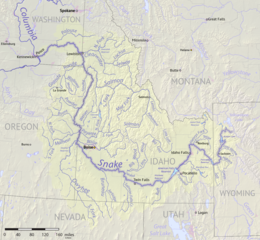
English: Map of the Snake River watershed, USA. Intended to replace older File:SnakeRiverNicerMap.jpg. Created using public domain USGS National Map data. |
| Date | |
| Soorce | Ain wirk |
| Author | Shannon1 |
Licensin
I, the copyright holder of this work, hereby publish it under the following licenses:

|
Permission is grantit tae copy, distribute an/or modify this document unner the terms o the GNU Free Documentation License, Version 1.2 or ony later version published bi the Free Software Foundation; wi no Invariant Sections, no Front-Cover Texts, an no Back-Cover Texts. A copy o the license is includit in the section enteetled GNU Free Documentation License. |
This file is licensed under the Creative Commons Attribution-Share Alike 4.0 International, 3.0 Unported, 2.5 Generic, 2.0 Generic and 1.0 Generic license.
- Ye are free:
- tae share – tae copy, distribute an transmit the wirk
- tae remix – tae adapt the wirk
- Unner the follaein condeetions:
- attribution – Ye must attribute the wirk in the manner specified bi the author or licensor (but nae in ony way that suggests that thay endorse ye or yer uise o the wirk).
- share alik – If ye alter, transform, or big upon this wirk, ye mey distribute the resultin wirk anly unner the same or seemilar license tae this ane.
Ye mey select the license o yer choice.
File history
Clap oan ae date/time fer tae see the file aes it kithed at that time.
| Date/Time | Thummnail | Dimensions | Uiser | Comment | |
|---|---|---|---|---|---|
| current | 02:45, 9 September 2017 | | 1,211 × 1,119 (2.1 MB) | Shannon1 | {{Information |Description ={{en|1=Map of the Snake River watershed, USA. Intended to replace older File:SnakeRiverNicerMap.jpg. Created using public domain USGS National Map data.}} |Source =Own work |Author =[[User:Shannon1|Sh... |
Eimage airtins
The follaein pages airts tae this image:
Global file uisage
The follaein ither wikis uise this file:
- Uisage on af.wikipedia.org
- Uisage on azb.wikipedia.org
- Uisage on be.wikipedia.org
- Uisage on bg.wikipedia.org
- Uisage on ca.wikipedia.org
- Uisage on ceb.wikipedia.org
- Uisage on cs.wikipedia.org
- Uisage on de.wikipedia.org
- Uisage on el.wikipedia.org
- Uisage on en.wikipedia.org
- Uisage on es.wikipedia.org
- Idaho
- Oregón
- Washington (estado)
- Boise
- Río Snake
- Pocatello (Idaho)
- Río Raft
- Río Portneuf
- Río Clearwater (Idaho)
- Río Boise
- Río Owyhee
- Baker City
- Ontario (Oregón)
- Vale (Oregón)
- Owyhee (Nevada)
- American Falls (Idaho)
- Ammon (Idaho)
- Blackfoot (Idaho)
- Jackson (Wyoming)
- Buhl (Idaho)
- Burley (Idaho)
- Emmett (Idaho)
- Homedale (Idaho)
- Idaho Falls
- McCall (Idaho)
- Meridian (Idaho)
- Mountain Home (Idaho)
- Nampa (Idaho)
View mair global usage o this file.