
File:San Francisco Bay Bridges map en.svg

Size of this PNG preview of this SVG file: 270 × 330 pixels. Ither resolutions: 196 × 240 pixels | 393 × 480 pixels | 628 × 768 pixels | 838 × 1,024 pixels | 1,676 × 2,048 pixels.
Oreeginal file (SVG file, nominallie 270 × 330 pixels, file size: 321 KB)
Ootline
| Descreeption |
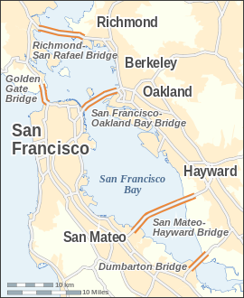
English: Map of the bridges of San Francisco Bay — in the San Francisco Bay Area, California.
|
| Date | |
| Soorce |
Ain wirk This W3C-unspecified vector image was created with Inkscape . |
| Author | Alexrk |
| Other versions | Derivative works of this file: San Francisco Bay Bridges map ar.pngDerivative works of this file: San Francisco Bay Bridges map ar.svg |

|
This map has been made or improved in the German Kartenwerkstatt (Map Lab). You can propose maps to improve as well.
|

|
This SVG file contains embedded text that can be translated into your language, using any capable SVG editor, text editor or the SVG Translate tool. For more information see: About translating SVG files. |
Licensin
I, the copyright holder of this work, hereby publish it under the following license:
This file is licensed unner the Creative Commons Attribution-Share Alike 3.0 Unported license.
- Ye are free:
- tae share – tae copy, distribute an transmit the wirk
- tae remix – tae adapt the wirk
- Unner the follaein condeetions:
- attribution – Ye must attribute the wirk in the manner specified bi the author or licensor (but nae in ony way that suggests that thay endorse ye or yer uise o the wirk).
- share alik – If ye alter, transform, or big upon this wirk, ye mey distribute the resultin wirk anly unner the same or seemilar license tae this ane.
File history
Clap oan ae date/time fer tae see the file aes it kithed at that time.
| Date/Time | Thummnail | Dimensions | Uiser | Comment | |
|---|---|---|---|---|---|
| current | 14:14, 24 Julie 2008 | | 270 × 330 (321 KB) | Alexrk | |
| 15:14, 19 Julie 2008 |  | 270 × 330 (321 KB) | Alexrk | 2 Scales: km & mi | |
| 14:01, 19 Julie 2008 |  | 270 × 330 (318 KB) | Alexrk | Scale, Size | |
| 13:49, 19 Julie 2008 |  | 287 × 347 (317 KB) | Alexrk | Revise Labels, Background | |
| 13:42, 19 Julie 2008 |  | 287 × 347 (306 KB) | Alexrk | Mess with fonts | |
| 13:33, 19 Julie 2008 |  | 287 × 347 (314 KB) | Alexrk | {{Information |Description={{en|1=Locator Map of San Francisco Bay bridges}} |Source=Own work by uploader |Author=Alexrk |Date= |Permission= |other_versions= }} {{ImageUpload|full}} |
Eimage airtins
The follaein pages airts tae this image:
Global file uisage
The follaein ither wikis uise this file:
- Uisage on arz.wikipedia.org
- Uisage on ast.wikipedia.org
- Uisage on bcl.wikipedia.org
- Uisage on bg.wikipedia.org
- Uisage on ca.wikipedia.org
- Uisage on cs.wikipedia.org
- Uisage on de.wikipedia.org
- Uisage on en.wikipedia.org
- Uisage on es.wikipedia.org
- Uisage on fi.wikipedia.org
- Uisage on fr.wikipedia.org
- Uisage on ga.wikipedia.org
- Uisage on gu.wikipedia.org
- Uisage on he.wikipedia.org
- Uisage on is.wikipedia.org
- Uisage on ml.wikipedia.org
- Uisage on my.wikipedia.org
- Uisage on pt.wikipedia.org
- Uisage on sl.wikipedia.org
- Uisage on ta.wikipedia.org
- Uisage on th.wikipedia.org
- Uisage on uk.wikipedia.org
View mair global usage o this file.