
File:Sahel Map-Africa rough.png
Size o this luikower: 800 × 370 pixels. Ither resolutions: 320 × 148 pixels | 640 × 296 pixels | 1,024 × 474 pixels | 2,000 × 925 pixels.
Oreeginal file (2,000 × 925 pixels, file size: 291 KB, MIME type: image/png)

|
This file requires updating because: south soudan In doing so, you could add a timestamp to the file.
|
| Descreeption |
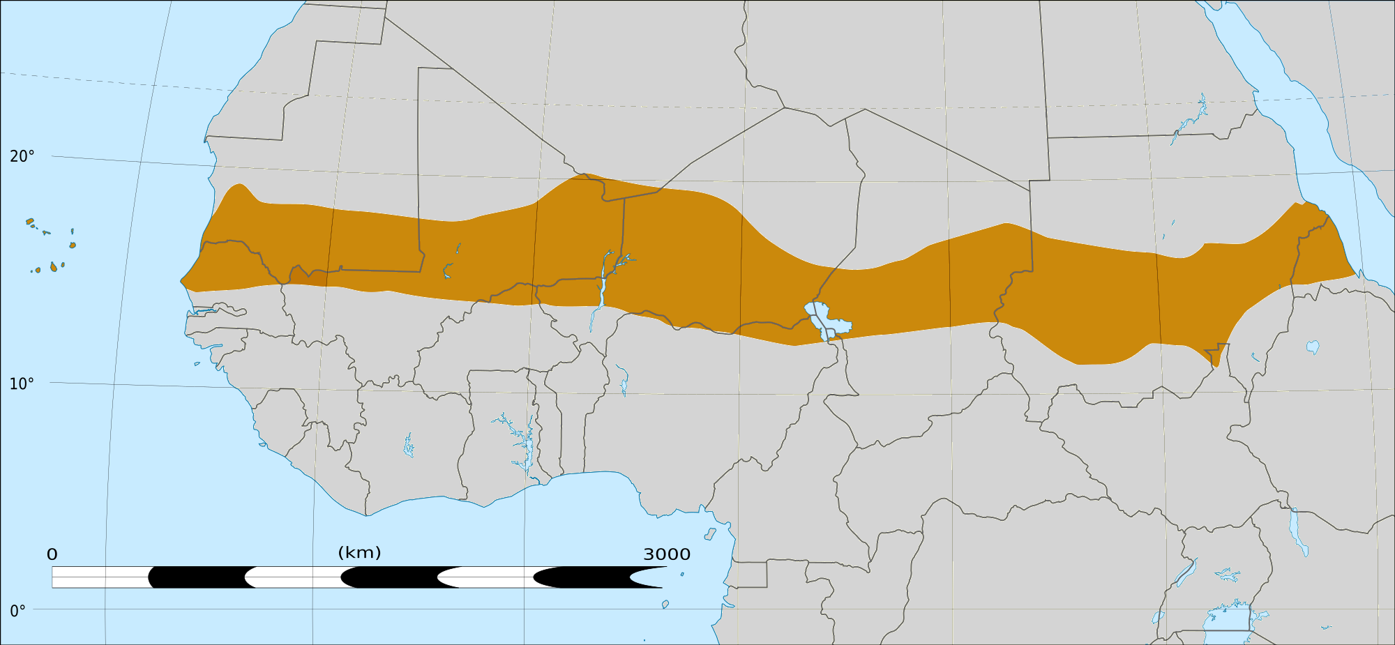
English: Map of Africa, with the Sahel highlighted in orange.
This is roughly the African land area between the lines of 200mm (north) and 600mm (south) mean 20th century annual rainfall. This is limited to land areas directly to the south of the Sahara desert and including the islands of Cape Verde, but not including other areas in Africa with the same rainfall statistics. This is one, but not the only, definition of the Sahel region. |
|||
| Date | 20 Febuair 2009 03:54 (UTC) | |||
| Soorce |
Felix Koenig: "created/photographed by myself (based on the existing blank map of Africa)"
|
|||
| Author | ||||
| Other versions |
|


| This is a retouched picture, which means that it has been digitally altered from its original version. Modifications: Reproduced Sahel boundary from Map sahel.jpg on png map, cropped. The original can be viewed here: BlankMap-Africa2.png:
|
Licensin
I, the copyright holder of this work, hereby publish it under the following licenses:

|
Permission is grantit tae copy, distribute an/or modify this document unner the terms o the GNU Free Documentation License, Version 1.2 or ony later version published bi the Free Software Foundation; wi no Invariant Sections, no Front-Cover Texts, an no Back-Cover Texts. A copy o the license is includit in the section enteetled GNU Free Documentation License. |
This file is licensed under the Creative Commons Attribution-Share Alike 4.0 International, 3.0 Unported, 2.5 Generic, 2.0 Generic and 1.0 Generic license.
- Ye are free:
- tae share – tae copy, distribute an transmit the wirk
- tae remix – tae adapt the wirk
- Unner the follaein condeetions:
- attribution – Ye must attribute the wirk in the manner specified bi the author or licensor (but nae in ony way that suggests that thay endorse ye or yer uise o the wirk).
- share alik – If ye alter, transform, or big upon this wirk, ye mey distribute the resultin wirk anly unner the same or seemilar license tae this ane.
Ye mey select the license o yer choice.
|
|
Permission is grantit tae copy, distribute an/or modify this document unner the terms o the GNU Free Documentation License, Version 1.2 or ony later version published bi the Free Software Foundation; wi no Invariant Sections, no Front-Cover Texts, an no Back-Cover Texts. A copy o the license is includit in the section enteetled GNU Free Documentation License. |
Original upload log
This image is a derivative work of the following images:
- File:Map_sahel.jpg licensed with GFDL
- 2005-05-30T17:36:46Z King 800x800 (89588 Bytes) one moment please
- File:BlankMap-Africa2.png licensed with Cc-by-sa-3.0,2.5,2.0,1.0, GFDL
- 2008-03-08T18:02:20Z Sadalmelik 1754x1546 (51013 Bytes) {{Information |Description=Blank map of Africa |Source=self-made |Date=2008-03-08 |Author= [[User:Sadalmelik|Sadalmelik]] |Permission= |other_versions= }} [[Category:Blank maps of Africa]]
Uploaded with derivativeFX
File history
Clap oan ae date/time fer tae see the file aes it kithed at that time.
| Date/Time | Thummnail | Dimensions | Uiser | Comment | |
|---|---|---|---|---|---|
| current | 16:15, 17 Mairch 2018 | | 2,000 × 925 (291 KB) | Maphobbyist | South Sudan border |
| 04:02, 20 Februar 2009 |  | 1,384 × 658 (29 KB) | T L Miles | {{Information |Description=*Description: A map of Africa: the Sahel highlighted in orange. Note, this is ROUGHLY the African land area between the lines of 200mm (north) and 600mm (south) mean 20th century annual rainfall. This is limited to land areas d |
Eimage airtins
The'r nae pages airts tae this eimage.
Global file uisage
The follaein ither wikis uise this file:
- Uisage on af.wikipedia.org
- Uisage on als.wikipedia.org
- Uisage on ar.wikipedia.org
- Uisage on az.wikipedia.org
- Uisage on bcl.wikipedia.org
- Uisage on be.wikipedia.org
- Uisage on bg.wikipedia.org
- Uisage on bn.wikipedia.org
- Uisage on br.wikipedia.org
- Uisage on ca.wikipedia.org
- Uisage on ce.wikipedia.org
- Uisage on da.wikipedia.org
- Uisage on en.wikipedia.org
- Uisage on eu.wikipedia.org
- Uisage on fa.wikipedia.org
- Uisage on fi.wiktionary.org
- Uisage on fr.wikipedia.org
- Uisage on fr.wikinews.org
- Uisage on ha.wikipedia.org
- Uisage on ig.wikipedia.org
- Uisage on incubator.wikimedia.org
- Uisage on it.wikipedia.org
- Uisage on ja.wikipedia.org
- Uisage on ka.wikipedia.org
- Uisage on ko.wikipedia.org
- Uisage on mg.wikipedia.org
- Uisage on mk.wikipedia.org
View mair global usage o this file.