
File:Ronda La Ciudad2004.jpg
Size o this luikower: 800 × 530 pixels. Ither resolutions: 320 × 212 pixels | 640 × 424 pixels | 981 × 650 pixels.
Oreeginal file (981 × 650 pixels, file size: 215 KB, MIME type: image/jpeg)
Ootline
| Descreeption |
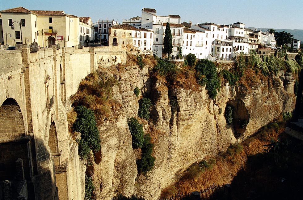
Ronda (Espana / Spanien / Spain) - El Puente Nuevo & La Ciudad ---- Deutsch: de:Ronda - Blick von der Plaza de España über die etwa 90 m tiefe, El Tajo genannte, Schlucht zur Altstadt. Links die im 18. Jahrhundert erbaute Brücke Puente Nuovo, welche die maurisch geprägte Altstadt, La Ciudad, mit dem jüngeren, aus der Zeit nach der de:Reconquista stammenden Teil der Stadt, El Mercadillo, verbindet. |
| Date | September 2004 |
| Soorce | photo taken by Manfred Werner (User:Tsui) // Foto von Manfred Werner (User:Tsui) |
| Author | Manfred Werner (User:Tsui or Tsui at de.wikipedia.org) |
| Permission (Reuisin this file) |
GNU-FDL |
| Camera location | | View this and other nearby images on: OpenStreetMap |
|---|

|
Permission is grantit tae copy, distribute an/or modify this document unner the terms o the GNU Free Documentation License, Version 1.2 or ony later version published bi the Free Software Foundation; wi no Invariant Sections, no Front-Cover Texts, an no Back-Cover Texts. A copy o the license is includit in the section enteetled GNU Free Documentation License. |
| This file is licensed unner the Creative Commons Attribution-Share Alike 3.0 Unported license. | ||
| ||
| This licensing tag was added to this file as part of the GFDL licensing update. |
File history
Clap oan ae date/time fer tae see the file aes it kithed at that time.
| Date/Time | Thummnail | Dimensions | Uiser | Comment | |
|---|---|---|---|---|---|
| current | 15:03, 15 November 2004 | | 981 × 650 (215 KB) | Tsui | Ronda - El Puente Nuevo and La Ciudad |
Eimage airtins
The'r nae pages airts tae this eimage.
Global file uisage
The follaein ither wikis uise this file:
- Uisage on ab.wikipedia.org
- Uisage on ar.wikipedia.org
- Uisage on be-tarask.wikipedia.org
- Uisage on bn.wikipedia.org
- Uisage on ca.wikipedia.org
- Uisage on ceb.wikipedia.org
- Uisage on cy.wikipedia.org
- Uisage on en.wikipedia.org
- Uisage on eo.wikipedia.org
- Uisage on es.wikipedia.org
- Uisage on es.wiktionary.org
- Uisage on eu.wikipedia.org
- Uisage on fi.wikipedia.org
- Uisage on fr.wikipedia.org
- Uisage on he.wikipedia.org
- Uisage on ht.wikipedia.org
- Uisage on hy.wikipedia.org
- Uisage on id.wikipedia.org
- Uisage on incubator.wikimedia.org
- Uisage on it.wikipedia.org
- Uisage on it.wikivoyage.org
- Uisage on ko.wikipedia.org
- Uisage on lv.wikipedia.org
- Uisage on ml.wikipedia.org
- Uisage on no.wikipedia.org
- Uisage on pl.wikipedia.org
- Uisage on pt.wikipedia.org
- Uisage on ro.wikipedia.org
- Uisage on sh.wikipedia.org
- Uisage on sl.wikipedia.org
- Uisage on sq.wikipedia.org
- Uisage on sr.wikipedia.org
- Uisage on szl.wikipedia.org
- Uisage on tk.wikipedia.org
- Uisage on www.wikidata.org
- Uisage on zh-min-nan.wikipedia.org