
File:River Forth course 3.png

Size o this luikower: 800 × 322 pixels. Ither resolutions: 320 × 129 pixels | 640 × 258 pixels | 1,024 × 413 pixels | 2,000 × 806 pixels.
Oreeginal file (2,000 × 806 pixels, file size: 981 KB, MIME type: image/png)
Ootline
| Descreeption |
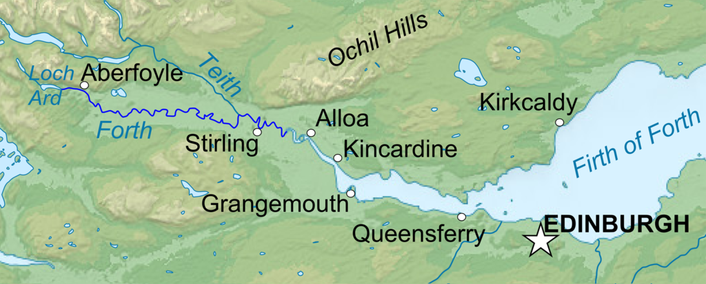
English: Topographic map in English of Scotland This is a lighter raster JPG format version of Image:Scotland_topographic_map-en.svg which should be used in the article pages, the vector graphics version purpose being for modification and / or translation. Français : Carte topographique en anglais de l'Écosse. *UTM projection ; WGS84 datum ; shaded relief (composite image of N-W, W and N lightning positions) ;Ceci est une version bitmap au format JPG et de poids de fichier plus léger de Image:Scotland_topographic_map-fr.svg qui devrait être utilisée dans les pages d'articles, la version vectorisée SVG étant destinée à faciliter les modifications et / ou traductions. *Scales: **Topography and shore/lakes limits: 1:872,000 (accuracy: 218 m) until 60.38° and 1:3,800,000 (accuracy: 950 m) North of 60.38° ; ** Bathymetry: 1:7,588,000 (accuracy: 1,897 m) |
| Date | (UTC) |
| Soorce |
This file was derived from: Scotland topographic map-en.jpg:  |
| Author |
|
| This is a retouched picture, which means that it has been digitally altered from its original version. Modifications: Isolated the river forth area. The original can be viewed here: Scotland topographic map-en.jpg:
|
Licensin
I, the copyright holder of this work, hereby publish it under the following licenses:
This file is licensed under the Creative Commons Attribution-Share Alike 3.0 Unported, 2.5 Generic, 2.0 Generic and 1.0 Generic license.
- Ye are free:
- tae share – tae copy, distribute an transmit the wirk
- tae remix – tae adapt the wirk
- Unner the follaein condeetions:
- attribution – Ye must attribute the wirk in the manner specified bi the author or licensor (but nae in ony way that suggests that thay endorse ye or yer uise o the wirk).
- share alik – If ye alter, transform, or big upon this wirk, ye mey distribute the resultin wirk anly unner the same or seemilar license tae this ane.

|
Permission is grantit tae copy, distribute an/or modify this document unner the terms o the GNU Free Documentation License, Version 1.2 or ony later version published bi the Free Software Foundation; wi no Invariant Sections, no Front-Cover Texts, an no Back-Cover Texts. A copy o the license is includit in the section enteetled GNU Free Documentation License. |
Ye mey select the license o yer choice.
Original upload log
This image is a derivative work of the following images:
- File:Scotland_topographic_map-en.jpg licensed with Cc-by-sa-3.0,2.5,2.0,1.0, GFDL
- 2010-07-17T21:41:29Z Sting 2400x3450 (2398211 Bytes) Color profile
- 2008-09-24T23:35:01Z Sting 2400x3450 (2082807 Bytes) Completely new background : raster topography and using ETOPO1 data for bathymetry ; new standard colors
- 2007-12-14T01:02:41Z Sting 2400x3450 (2224139 Bytes) Additional name
- 2007-12-12T20:55:32Z Sting 2400x3450 (2220337 Bytes) Correction in key
- 2007-12-12T16:18:25Z Sting 2400x3450 (2218854 Bytes) {{Location|57|00|00|N|04|00|00|W|scale:4000000}} {{Information |Description=Topographic map in English of [[:en:Scotland|Scotland]]This is a lighter raster JPG format version of [[:Image:Scotland_topographic_map-en.svg]] whi
Uploaded with derivativeFX
File history
Clap oan ae date/time fer tae see the file aes it kithed at that time.
| Date/Time | Thummnail | Dimensions | Uiser | Comment | |
|---|---|---|---|---|---|
| current | 22:04, 22 Januar 2013 | 2,000 × 806 (981 KB) | VanguardScot | Added loch ard, highlighted the actual river forth | |
| 21:57, 22 Januar 2013 | 2,988 × 1,204 (991 KB) | VanguardScot | added grangemouth | ||
| 22:27, 17 Januar 2013 | 715 × 263 (314 KB) | VanguardScot | == {{int:filedesc}} == {{Information |Description={{en|Topographic map in English of Scotland<br/>This is a lighter raster JPG format version of Image:Scotland_topographic_map-en.svg which should be used in the article pages, the ... |
Eimage airtins
The'r nae pages airts tae this eimage.
Global file uisage
The follaein ither wikis uise this file:
- Uisage on ca.wikipedia.org
- Uisage on cs.wikipedia.org
- Uisage on en.wikipedia.org
- Uisage on et.wikipedia.org
- Uisage on fa.wikipedia.org
- Uisage on fi.wikipedia.org
- Uisage on fr.wikipedia.org
- Uisage on he.wikipedia.org
- Uisage on is.wikipedia.org
- Uisage on it.wikipedia.org
- Uisage on ja.wikipedia.org
- Uisage on no.wikipedia.org
- Uisage on sh.wikipedia.org
- Uisage on sr.wikipedia.org
- Uisage on uk.wikipedia.org