
File:PigWar-boundaries.png
Size o this luikower: 742 × 600 pixels. Ither resolutions: 297 × 240 pixels | 594 × 480 pixels | 950 × 768 pixels | 1,058 × 855 pixels.
Oreeginal file (1,058 × 855 pixels, file size: 637 KB, MIME type: image/png)
Ootline
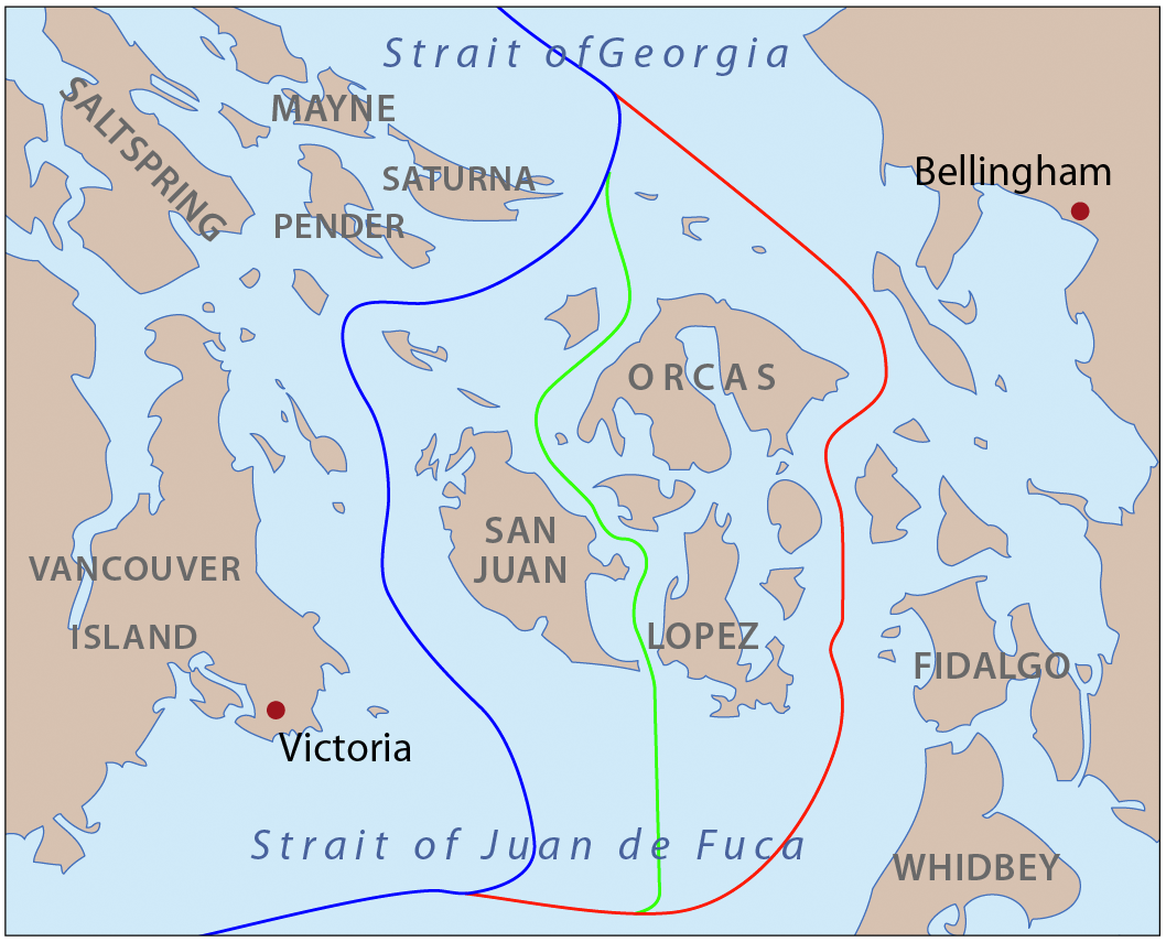
| Descreeption | This is a map of the proposed boundaries between the United States and Canada around the San Juan Islands, for use in describing the Pig War. I, Pfly, made it with ArcGIS, Adobe Illustrator, and Adobe Photoshop. |
| Date | |
| Soorce | self-made, information one boundaries from Hayes, Derek, Historical Atlas of the Pacific Northwest. |
| Author | Pfly |
Licensin
I, the copyright holder of this work, hereby publish it under the following licenses:
This file is licensed unner the Creative Commons Attribution-Share Alike 3.0 Unported license.
- Ye are free:
- tae share – tae copy, distribute an transmit the wirk
- tae remix – tae adapt the wirk
- Unner the follaein condeetions:
- attribution – Ye must attribute the wirk in the manner specified bi the author or licensor (but nae in ony way that suggests that thay endorse ye or yer uise o the wirk).
- share alik – If ye alter, transform, or big upon this wirk, ye mey distribute the resultin wirk anly unner the same or seemilar license tae this ane.

|
Permission is grantit tae copy, distribute an/or modify this document unner the terms o the GNU Free Documentation License, Version 1.2 or ony later version published bi the Free Software Foundation; wi no Invariant Sections, no Front-Cover Texts, an no Back-Cover Texts. A copy o the license is includit in the section enteetled GNU Free Documentation License. |
Ye mey select the license o yer choice.
File history
Clap oan ae date/time fer tae see the file aes it kithed at that time.
| Date/Time | Thummnail | Dimensions | Uiser | Comment | |
|---|---|---|---|---|---|
| current | 20:49, 24 Juin 2011 | | 1,058 × 855 (637 KB) | Pfly | Correct boundaries to go west of Patos Island. |
| 01:31, 16 Mey 2008 |  | 384 × 309 (60 KB) | Pfly | {{Information |Description=This is a map of the proposed boundaries between the United States and Canada around the San Juan Islands, for use in describing the Pig War. I, Pfly, made it with [[:en |
Eimage airtins
The follaein pages airts tae this image:
Global file uisage
The follaein ither wikis uise this file:
- Uisage on az.wikipedia.org
- Uisage on da.wikipedia.org
- Uisage on de.wikipedia.org
- Uisage on en.wikipedia.org
- Uisage on en.wiktionary.org
- Uisage on es.wikipedia.org
- Uisage on eu.wikipedia.org
- Uisage on fi.wikipedia.org
- Uisage on fr.wikipedia.org
- Uisage on he.wikipedia.org
- Uisage on hy.wikipedia.org
- Uisage on it.wikipedia.org
- Uisage on ja.wikipedia.org
- Uisage on ko.wikipedia.org
- Uisage on no.wikipedia.org
- Uisage on pl.wikipedia.org
- Uisage on pt.wikipedia.org
- Uisage on ro.wikipedia.org
- Uisage on ru.wikipedia.org
- Uisage on simple.wikipedia.org
- Uisage on sv.wikipedia.org
- Uisage on th.wikipedia.org
- Uisage on uk.wikipedia.org
- Uisage on www.wikidata.org
- Uisage on zh.wikipedia.org