
File:Oder.png

Size o this luikower: 583 × 600 pixels. Ither resolutions: 233 × 240 pixels | 467 × 480 pixels | 747 × 768 pixels | 1,060 × 1,090 pixels.
Oreeginal file (1,060 × 1,090 pixels, file size: 1.17 MB, MIME type: image/png)

|
This map image could be re-created using vector graphics as an SVG file. This has several advantages; see Commons:Media for cleanup for more information. If an SVG form of this image is available, please upload it and afterwards replace this template with
{{vector version available|new image name}}.
It is recommended to name the SVG file “Oder.svg”—then the template Vector version available (or Vva) does not need the new image name parameter. |
Ootline
| Descreeption |
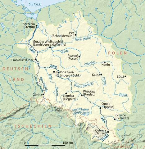
Deutsch: Einzugsgebiet der Oder, deutsche Version
English: Drainage basin of the Oder, German version |
| Date | |
| Soorce | Ain wirk |
| Author | NordNordWest |
| Other versions | Dorzecze Odry mapa.png (Polish lang. version) |

|
This map has been made or improved in the German Kartenwerkstatt (Map Lab). You can propose maps to improve as well.
|
Licensin
I, the copyright holder of this work, hereby publish it under the following licenses:

|
Permission is grantit tae copy, distribute an/or modify this document unner the terms o the GNU Free Documentation License, Version 1.2 or ony later version published bi the Free Software Foundation; wi no Invariant Sections, no Front-Cover Texts, an no Back-Cover Texts. A copy o the license is includit in the section enteetled GNU Free Documentation License. |
This file is licensed unner the Creative Commons Attribution-Share Alike 3.0 Unported license.
- Ye are free:
- tae share – tae copy, distribute an transmit the wirk
- tae remix – tae adapt the wirk
- Unner the follaein condeetions:
- attribution – Ye must attribute the wirk in the manner specified bi the author or licensor (but nae in ony way that suggests that thay endorse ye or yer uise o the wirk).
- share alik – If ye alter, transform, or big upon this wirk, ye mey distribute the resultin wirk anly unner the same or seemilar license tae this ane.
Ye mey select the license o yer choice.
File history
Clap oan ae date/time fer tae see the file aes it kithed at that time.
| Date/Time | Thummnail | Dimensions | Uiser | Comment | |
|---|---|---|---|---|---|
| current | 10:13, 4 Januar 2010 | | 1,060 × 1,090 (1.17 MB) | NordNordWest | |
| 19:40, 27 Mairch 2008 |  | 1,063 × 1,092 (1.17 MB) | NordNordWest | ||
| 11:39, 9 Mairch 2008 |  | 1,063 × 1,092 (505 KB) | NordNordWest | ||
| 16:43, 24 Februar 2008 |  | 1,063 × 1,092 (796 KB) | NordNordWest | ||
| 15:53, 21 Februar 2008 |  | 1,063 × 1,092 (794 KB) | NordNordWest | ||
| 20:10, 20 Februar 2008 |  | 1,062 × 1,090 (898 KB) | NordNordWest | {{Information |Description={{de}} Einzugsgebiet der Oder {{en}} Drainage basin of Oder River |Source=self-made |Date=20-02-2008 |Author= Titus Groan |Permission= |other_versions= }} Category:Maps of rivers of Europe |
Eimage airtins
The follaein pages airts tae this image:
Global file uisage
The follaein ither wikis uise this file:
- Uisage on af.wikipedia.org
- Uisage on ar.wikipedia.org
- Uisage on azb.wikipedia.org
- Uisage on bg.wikipedia.org
- Uisage on bn.wikipedia.org
- Uisage on br.wikipedia.org
- Uisage on ca.wikipedia.org
- Uisage on cs.wikipedia.org
- Uisage on cy.wikipedia.org
- Uisage on da.wikipedia.org
- Uisage on de.wikipedia.org
- Oder
- Wikipedia:Kartenwerkstatt/Archiv/2008-02
- Internationale Kommission zum Schutz der Oder gegen Verunreinigung
- Wikipedia:WikiProjekt Flussverlaufskarten
- Wikipedia Diskussion:WikiProjekt Flussverlaufskarten
- Benutzer:Francis McLloyd/Oder/Becken
- Benutzer:Methodios/Polen (Hydrogeographie)
- Umweltkatastrophe in der Oder 2022
- Uisage on de.wikinews.org
- Uisage on dsb.wikipedia.org
- Uisage on en.wikipedia.org
View mair global usage o this file.