
File:Novgorod1400.png
Size o this luikower: 800 × 498 pixels. Ither resolutions: 320 × 199 pixels | 640 × 398 pixels | 900 × 560 pixels.
Oreeginal file (900 × 560 pixels, file size: 24 KB, MIME type: image/png)
Ootline
| Descreeption |
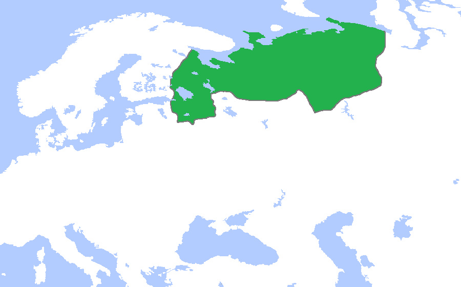
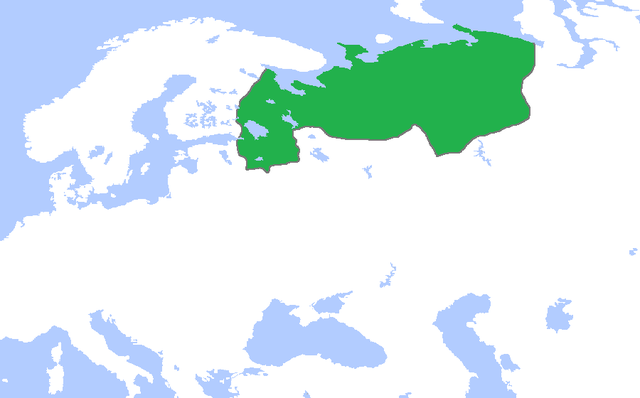
English: Locator map of the Novgorod Republic, c. 1400. (Partially based on Atlas of World History (2007) - The World 1300-1400, map)
中文:绿色部分为诺夫哥罗德公国的最大势力范围(约1400年)。 |
| Date | |
| Soorce | Ain wirk |
| Author | Gabagool |
Licensin
I, the copyright holder of this work, hereby publish it under the following license:
This file is licensed under the Creative Commons Attribution 3.0 Unported license.
- Ye are free:
- tae share – tae copy, distribute an transmit the wirk
- tae remix – tae adapt the wirk
- Unner the follaein condeetions:
- attribution – Ye must attribute the wirk in the manner specified bi the author or licensor (but nae in ony way that suggests that thay endorse ye or yer uise o the wirk).
File history
Clap oan ae date/time fer tae see the file aes it kithed at that time.
| Date/Time | Thummnail | Dimensions | Uiser | Comment | |
|---|---|---|---|---|---|
| current | 23:01, 30 Mey 2009 | | 900 × 560 (24 KB) | Gabagool | cropped |
| 15:44, 24 Apryle 2009 |  | 1,264 × 788 (40 KB) | Gabagool | {{Information |Description={{en|1=Locator map of the Novgorod Republic, c. 1400. (Partially based on ''Atlas of World History'' (2007) - The World 1300-1400, map)}} |Source=Own work by uploader |Author=Gabagool / Jarle Grøhn |Date=2009 |
Eimage airtins
The follaein pages airts tae this image:
Global file uisage
The follaein ither wikis uise this file:
- Uisage on af.wikipedia.org
- Uisage on ar.wikipedia.org
- Uisage on arz.wikipedia.org
- Uisage on ast.wikipedia.org
- Uisage on azb.wikipedia.org
- Uisage on az.wikipedia.org
- Uisage on ba.wikipedia.org
- Uisage on be-tarask.wikipedia.org
- Uisage on be.wikipedia.org
- Uisage on bg.wikipedia.org
- Uisage on ca.wikipedia.org
- Uisage on cs.wikipedia.org
- Uisage on da.wikipedia.org
- Uisage on de.wikipedia.org
- Uisage on el.wikipedia.org
- Uisage on en.wikipedia.org
- Uisage on eo.wikipedia.org
- Uisage on es.wikipedia.org
- Uisage on et.wikipedia.org
- Uisage on eu.wikipedia.org
- Uisage on fa.wikipedia.org
- Uisage on fi.wikipedia.org
- Uisage on fr.wikipedia.org
- Uisage on gl.wikipedia.org
- Uisage on he.wikipedia.org
- Uisage on hr.wikipedia.org
- Uisage on hu.wikipedia.org
- Uisage on hy.wikipedia.org
- Uisage on io.wikipedia.org
- Uisage on it.wikipedia.org
- Uisage on ja.wikipedia.org
- Uisage on ko.wikipedia.org
- Uisage on ky.wikipedia.org
- Uisage on la.wikipedia.org
- Uisage on lld.wikipedia.org
- Uisage on lt.wikipedia.org
View mair global usage o this file.