
File:Morayfirthmap.png

Size o this luikower: 597 × 600 pixels. Ither resolutions: 239 × 240 pixels | 478 × 480 pixels | 995 × 1,000 pixels.
Oreeginal file (995 × 1,000 pixels, file size: 280 KB, MIME type: image/png)
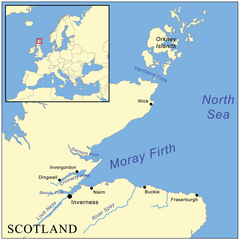
| Descreeption | This is a map of the Moray Firth including a small locator map, based on Digital Chart of the World data. |
| Date | |
| Soorce | Ain wirk |
| Author | Kmusser |
I, the copyright holder of this work, hereby publish it under the following license:
This file is licensed under the Creative Commons Attribution-Share Alike 2.5 Generic license.
- Ye are free:
- tae share – tae copy, distribute an transmit the wirk
- tae remix – tae adapt the wirk
- Unner the follaein condeetions:
- attribution – Ye must attribute the wirk in the manner specified bi the author or licensor (but nae in ony way that suggests that thay endorse ye or yer uise o the wirk).
- share alik – If ye alter, transform, or big upon this wirk, ye mey distribute the resultin wirk anly unner the same or seemilar license tae this ane.
File history
Clap oan ae date/time fer tae see the file aes it kithed at that time.
| Date/Time | Thummnail | Dimensions | Uiser | Comment | |
|---|---|---|---|---|---|
| current | 09:47, 4 Julie 2012 | | 995 × 1,000 (280 KB) | Dricherby | sp Dornoch (was "Dornach"). |
| 16:11, 22 Mey 2007 |  | 995 × 1,000 (317 KB) | Kmusser | fix montenegro boundary | |
| 16:01, 22 Mey 2007 |  | 995 × 1,000 (317 KB) | Kmusser | {{Information |Description=This is a map of the Moray Firth including a small locator map, based on Digital Chart of the World data. |Source=self-made |Date= May 22, 2007 |Author= User:Kmusser |
Eimage airtins
The follaein pages airts tae this image:
Global file uisage
The follaein ither wikis uise this file:
- Uisage on br.wikipedia.org
- Uisage on de.wikipedia.org
- Uisage on en.wikipedia.org
- Uisage on es.wikipedia.org
- Uisage on fi.wikipedia.org
- Uisage on fr.wikipedia.org
- Uisage on gd.wikipedia.org
- Uisage on ia.wikipedia.org
- Uisage on it.wikipedia.org
- Uisage on ja.wikipedia.org
- Uisage on nl.wikipedia.org
- Uisage on nn.wikipedia.org
- Uisage on no.wikipedia.org
- Uisage on pl.wikipedia.org
- Uisage on ru.wikipedia.org
- Uisage on vi.wikipedia.org