
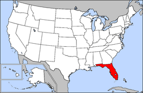
File:Map of USA highlighting Florida.png
Nae heier resolution available.
Map_of_USA_highlighting_Florida.png (280 × 183 pixels, file size: 45 KB, MIME type: image/png)

|
File:Map of USA FL.svg is a vector version o this file. It should be uised in place o this raster image when nae inferior.
File:Map of USA highlighting Florida.png → File:Map of USA FL.svg
For mair information, see Help:SVG. |
 |
Ootline
Public domain map courtesy of The General Libraries, The University of Texas at Austin, modified to highlight state boundaries.
Source: Modified version of United States (Outline Map) 1998 from Perry-Castañeda Library Map Collection: United States Maps
Licensin

|
Permission is grantit tae copy, distribute an/or modify this document unner the terms o the GNU Free Documentation License, Version 1.2 or ony later version published bi the Free Software Foundation; wi no Invariant Sections, no Front-Cover Texts, an no Back-Cover Texts. A copy o the license is includit in the section enteetled GNU Free Documentation License. |
| This file is licensed unner the Creative Commons Attribution-Share Alike 3.0 Unported license. | ||
| ||
| This licensing tag was added to this file as part of the GFDL licensing update. |
From English Wikipedia.
File history
Clap oan ae date/time fer tae see the file aes it kithed at that time.
| Date/Time | Thummnail | Dimensions | Uiser | Comment | |
|---|---|---|---|---|---|
| current | 21:56, 28 Mairch 2005 | | 280 × 183 (45 KB) | David.gaya | From English Wikipedia: Public domain map courtesy of [http://www.lib.utexas.edu/ The General Libraries, The University of Texas at Austin], modified to highlight state boundaries. {{GFDL}} Category:State locator maps of the United States |
Eimage airtins
The follaein pages airts tae this image:
Global file uisage
The follaein ither wikis uise this file:
- Uisage on bat-smg.wikipedia.org
- Uisage on bi.wikipedia.org
- Uisage on br.wikipedia.org
- Uisage on en.wikipedia.org
- Uisage on en.wikinews.org
- Uisage on en.wiktionary.org
- Uisage on eo.wikipedia.org
- Uisage on es.wikipedia.org
- Uisage on fr.wikinews.org
- Uisage on he.wikipedia.org
- Uisage on kw.wikipedia.org
- Uisage on li.wikipedia.org
- Uisage on nl.wikipedia.org
- Uisage on no.wikipedia.org
- Uisage on no.wiktionary.org
- Uisage on pam.wikipedia.org
- Uisage on pap.wikipedia.org
- Uisage on pl.wikipedia.org
- Uisage on pt.wikipedia.org
- Uisage on rm.wikipedia.org
- Uisage on ro.wikipedia.org
- Uisage on ru.wikipedia.org
- Uisage on ru.wiktionary.org
- Uisage on sv.wikinews.org
- 20 dog då sjöflygplan exploderade utanför Miami
- Huvudnyheter/December 2005
- Golf
- Annika i topp i damernas första världsranking
- Woods i ledning efter första rundan
- Chopra har tätkänning i jämn toppstrid
- Sista året för Ford som PGA-sponsor
- Chopra i ledarboll med Woods
- Woods höll undan och vann
- Två svenskar jagar täten i Honda Classic
- Chopra och Grönberg jagar vidare
- Spelare protesterar mot amerikansk dominans
- Luke Donald tog sin första PGA-seger på fyra år
- Wilson och Bryant i delad ledning i Bay Hill Invitational
- Glover i topp i Bay Hill Invitational
- Rod Pampling vann Bay Hill Invitational
View mair global usage o this file.