
File:Map of Franz Josef Land-en.svg

Size of this PNG preview of this SVG file: 800 × 535 pixels. Ither resolutions: 320 × 214 pixels | 640 × 428 pixels | 1,024 × 685 pixels | 1,280 × 856 pixels | 2,560 × 1,712 pixels | 1,289 × 862 pixels.
Oreeginal file (SVG file, nominallie 1,289 × 862 pixels, file size: 719 KB)
Ootline
| Descreeption |
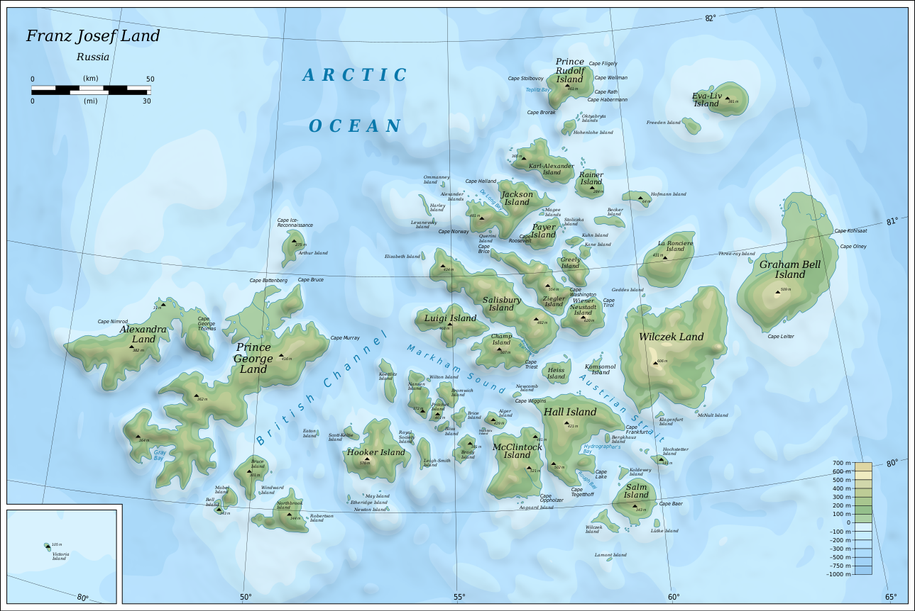
English: Map of Franz Josef Land of Russia. |
| Date | |
| Soorce |
Own work using: Inkscape.
|
| Author | Oona Räisänen |
| Other versions |
|
| SVG genesis |


Licensin
I, the copyright holder of this work, hereby publish it under the following licenses:
This file is licensed unner the Creative Commons Attribution-Share Alike 3.0 Unported license.
- Ye are free:
- tae share – tae copy, distribute an transmit the wirk
- tae remix – tae adapt the wirk
- Unner the follaein condeetions:
- attribution – Ye must attribute the wirk in the manner specified bi the author or licensor (but nae in ony way that suggests that thay endorse ye or yer uise o the wirk).
- share alik – If ye alter, transform, or big upon this wirk, ye mey distribute the resultin wirk anly unner the same or seemilar license tae this ane.

|
Permission is grantit tae copy, distribute an/or modify this document unner the terms o the GNU Free Documentation License, Version 1.2 or ony later version published bi the Free Software Foundation; wi no Invariant Sections, no Front-Cover Texts, an no Back-Cover Texts. A copy o the license is includit in the section enteetled GNU Free Documentation License. |
Ye mey select the license o yer choice.
File history
Clap oan ae date/time fer tae see the file aes it kithed at that time.
| Date/Time | Thummnail | Dimensions | Uiser | Comment | |
|---|---|---|---|---|---|
| current | 06:05, 12 August 2019 | | 1,289 × 862 (719 KB) | Cherkash | fixed some objects: names spelling, location |
| 14:24, 28 October 2010 |  | 1,289 × 862 (719 KB) | Mysid | shading + fixes | |
| 19:21, 26 October 2010 |  | 1,289 × 862 (719 KB) | Mysid | bigger fonts | |
| 19:13, 26 October 2010 |  | 1,289 × 862 (718 KB) | Mysid | {{Information |Description={{en|1=Map of en:Franz Josef Land of Russia.}} |Source={{own}}. Self-made in Inkscape. Topography and shoreline manually derived from a 1964 map by United States Army Map Service, Corps of Engineers ([[:File:NU-38-39-40-41 |
Eimage airtins
The'r nae pages airts tae this eimage.
Global file uisage
The follaein ither wikis uise this file:
- Uisage on af.wikipedia.org
- Uisage on ar.wikipedia.org
- Uisage on avk.wikipedia.org
- Wilczek (ewala)
- Teza:FranzJosefTursia
- Salm (ewala)
- Lütke (ewala)
- Hochstetter (ewala)
- Wilczek (ewalama)
- Schönau (ewala)
- Koldewey (ewala)
- Hall (ewala)
- Berghaus (ewala)
- McClintock (ewala)
- Heiss (ewala)
- Komsomol (ewala)
- Newcomb (ewala)
- Alger (ewala)
- Brice (ewala)
- Brady (ewala)
- Bliss (ewala)
- Nansen (ewala)
- Pritchett (ewala)
- Bromwich (ewala)
- Koettlitz (ewala)
- Hooker (ewala)
- Scott-Keltie (ewala)
- Royal Society (ewala)
- Leigh-Smith (ewala)
- Luigi (ewala)
- Salisbury (ewala)
- Champ (ewala)
- Ziegler (ewala)
- Wiener Neustadt (ewala)
- Franz-Josef (tursia)
- Greely (ewala)
- Kane (ewala)
- Kuhn (ewala)
- Payer (ewala)
- Jackson (ewala)
- Karl-Alexander (ewala)
- Rainer (ewala)
- Hohenlohe (ewala)
- Prince Rudolf (ewala)
- La Roncière (ewala)
- Becker (ewala)
- Hofmann (ewala)
- Freeden (ewala)
- Eva-Liv (ewala)
- Graham Bell (ewala)
- Bruce (ewala)
View mair global usage o this file.