
File:Map - NL - Municipality code 0096 (2009).svg

Size of this PNG preview of this SVG file: 300 × 160 pixels. Ither resolutions: 320 × 171 pixels | 640 × 341 pixels | 1,024 × 546 pixels | 1,280 × 683 pixels | 2,560 × 1,365 pixels.
Oreeginal file (SVG file, nominallie 300 × 160 pixels, file size: 530 KB)
| Descreeption |
|
|||
| Date | ||||
| Soorce | own work , using CBS data | |||
| Author | Michiel1972 (talk) 21:45, 24 January 2009 (UTC) | |||
| Permission (Reuisin this file) |
Attribution ShareAlike 3.0 |

.svg)
This file is licensed unner the Creative Commons Attribution-Share Alike 3.0 Unported license.
- Ye are free:
- tae share – tae copy, distribute an transmit the wirk
- tae remix – tae adapt the wirk
- Unner the follaein condeetions:
- attribution – Ye must attribute the wirk in the manner specified bi the author or licensor (but nae in ony way that suggests that thay endorse ye or yer uise o the wirk).
- share alik – If ye alter, transform, or big upon this wirk, ye mey distribute the resultin wirk anly unner the same or seemilar license tae this ane.
File history
Clap oan ae date/time fer tae see the file aes it kithed at that time.
| Date/Time | Thummnail | Dimensions | Uiser | Comment | |
|---|---|---|---|---|---|
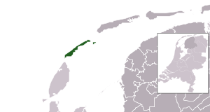
| current | 21:45, 24 Januar 2009 | | 300 × 160 (530 KB) | Michiel1972 | {{Information |Description=*Location maps for the 441 municipalities in the Netherlands. Boundaries 1/1/2009 *Automatically generated with script *File name contains "Municipality code" (CBS-code) as specified in: [http://www.cbs.nl/nl-NL/menu/methoden/c |
Eimage airtins
The'r nae pages airts tae this eimage.
Global file uisage
The follaein ither wikis uise this file:
- Uisage on ar.wikipedia.org
- Uisage on en.wikipedia.org
- Uisage on fa.wikipedia.org
- Uisage on frr.wikipedia.org
- Uisage on fr.wikipedia.org
- Uisage on hu.wikipedia.org
- Uisage on hy.wikipedia.org
- Uisage on la.wikipedia.org
- Uisage on nl.wikipedia.org
- Uisage on ru.wikipedia.org
- Uisage on stq.wikipedia.org
- Uisage on tr.wikipedia.org
- Uisage on uk.wikipedia.org
- Uisage on zh-min-nan.wikipedia.org
- Uisage on zh.wikipedia.org
.svg)